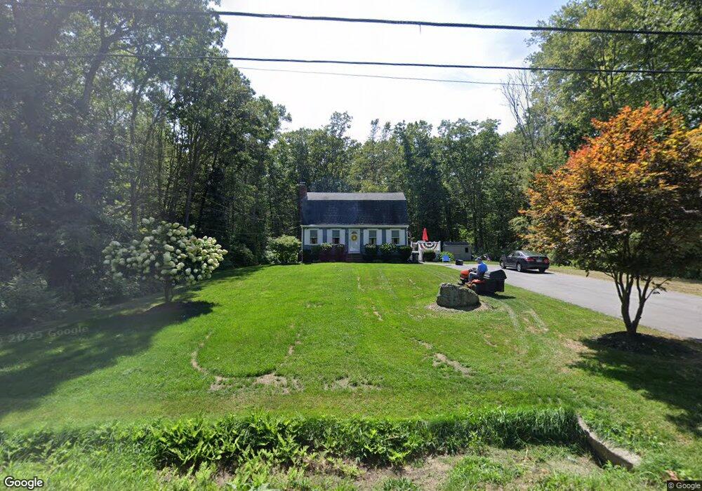
1881 Maple St North Dighton, MA 02764
Estimated Value: $480,909 - $596,000
3
Beds
1
Bath
1,536
Sq Ft
$344/Sq Ft
Est. Value
About This Home
This home is located at 1881 Maple St, North Dighton, MA 02764 and is currently estimated at $528,477, approximately $344 per square foot. 1881 Maple St is a home located in Bristol County with nearby schools including Dighton-Rehoboth Regional High School and Cedar Brook School.
Ownership History
Date
Name
Owned For
Owner Type
Purchase Details
Closed on
Oct 30, 2025
Sold by
Wade Joseph F and Wade Barbara A
Bought by
Wade Ft and Wade
Current Estimated Value
Purchase Details
Closed on
Oct 17, 1973
Bought by
Wade Joseph F and Wade Barbara
Create a Home Valuation Report for This Property
The Home Valuation Report is an in-depth analysis detailing your home's value as well as a comparison with similar homes in the area
Home Values in the Area
Average Home Value in this Area
Purchase History
| Date | Buyer | Sale Price | Title Company |
|---|---|---|---|
| Wade Ft | -- | -- | |
| Wade Joseph F | $4,500 | -- |
Source: Public Records
Mortgage History
| Date | Status | Borrower | Loan Amount |
|---|---|---|---|
| Previous Owner | Wade Joseph F | $82,000 | |
| Previous Owner | Wade Joseph F | $80,000 | |
| Previous Owner | Wade Joseph F | $80,000 |
Source: Public Records
Tax History
| Year | Tax Paid | Tax Assessment Tax Assessment Total Assessment is a certain percentage of the fair market value that is determined by local assessors to be the total taxable value of land and additions on the property. | Land | Improvement |
|---|---|---|---|---|
| 2025 | $4,564 | $363,400 | $134,900 | $228,500 |
| 2024 | $4,566 | $333,800 | $134,500 | $199,300 |
| 2023 | $4,362 | $312,900 | $134,500 | $178,400 |
| 2022 | $4,204 | $294,200 | $131,000 | $163,200 |
| 2021 | $3,974 | $268,000 | $118,400 | $149,600 |
| 2020 | $3,985 | $266,000 | $132,300 | $133,700 |
| 2019 | $3,878 | $258,700 | $132,300 | $126,400 |
| 2018 | $4,159 | $237,700 | $112,300 | $125,400 |
| 2017 | $3,849 | $233,500 | $130,600 | $102,900 |
| 2016 | $3,503 | $230,000 | $134,500 | $95,500 |
| 2015 | $3,468 | $234,300 | $138,400 | $95,900 |
| 2014 | $3,480 | $228,500 | $138,400 | $90,100 |
Source: Public Records
Map
Nearby Homes
- 2201 Wheeler St
- 593 Williams St
- 1421 Tremont St
- 0 Monteiro Unit 71870472
- 2140 Tanglewood Rd
- 0 Horton St Unit 73333337
- 2713 Horton St
- 24 New St
- 0 Range Ave Unit 72771508
- 0 Range Ave Unit 72771509
- 810 Tremont St
- 0 Wellington St
- 263 Summer St
- 1022 Rowland Dr
- 7 Maris Ln
- 1355 Pine St
- 0 Kimberly Rd
- 47 Caroline Dr
- Lot 3 Rocky Woods St
- 88 Morgan Dr
- 1909 Maple St
- 1851 Maple St
- 1870 Maple St
- 1920 Maple St
- 1821 Maple St
- 1800 Maple St
- 1874 Maple St
- 1940 Maple St
- 1777 Maple St
- 1780 Maple St
- 530 Tiger Lily Rd
- 1968 Maple St
- 510 Tiger Lily Rd
- 0 Tiger Lily Rd
- 25 Tiger Lily Rd
- 527 Tiger Lily Rd
- 1980 Maple St
- 1754 Maple St
- 494 Tiger Lily Rd
- 507 Tiger Lily Rd
Your Personal Tour Guide
Ask me questions while you tour the home.