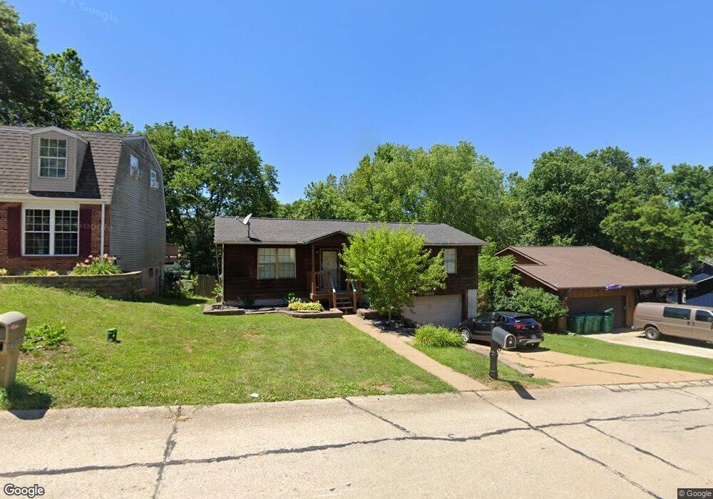
1885 Catlin Dr Barnhart, MO 63012
Estimated Value: $219,245 - $265,000
Studio
--
Bath
1,104
Sq Ft
$221/Sq Ft
Est. Value
About This Home
This home is located at 1885 Catlin Dr, Barnhart, MO 63012 and is currently estimated at $244,311, approximately $221 per square foot. 1885 Catlin Dr is a home located in Jefferson County with nearby schools including Windsor High School and St. Joseph Catholic School.
Ownership History
Date
Name
Owned For
Owner Type
Purchase Details
Closed on
Feb 4, 2020
Sold by
Robinson Frances M
Bought by
Cox Matthew and Cox Mindi
Current Estimated Value
Home Financials for this Owner
Home Financials are based on the most recent Mortgage that was taken out on this home.
Original Mortgage
$163,000
Outstanding Balance
$144,404
Interest Rate
3.74%
Mortgage Type
VA
Estimated Equity
$99,907
Purchase Details
Closed on
Jul 6, 2007
Sold by
Nahlik Tom V and Nahlik Karolynn
Bought by
Robinson Frances M
Home Financials for this Owner
Home Financials are based on the most recent Mortgage that was taken out on this home.
Original Mortgage
$155,900
Interest Rate
6.41%
Mortgage Type
Purchase Money Mortgage
Create a Home Valuation Report for This Property
The Home Valuation Report is an in-depth analysis detailing your home's value as well as a comparison with similar homes in the area
Home Values in the Area
Average Home Value in this Area
Purchase History
| Date | Buyer | Sale Price | Title Company |
|---|---|---|---|
| Cox Matthew | -- | None Available | |
| Robinson Frances M | -- | Htc |
Source: Public Records
Mortgage History
| Date | Status | Borrower | Loan Amount |
|---|---|---|---|
| Open | Cox Matthew | $163,000 | |
| Previous Owner | Robinson Frances M | $155,900 |
Source: Public Records
Tax History
| Year | Tax Paid | Tax Assessment Tax Assessment Total Assessment is a certain percentage of the fair market value that is determined by local assessors to be the total taxable value of land and additions on the property. | Land | Improvement |
|---|---|---|---|---|
| 2025 | $1,561 | $22,900 | $4,800 | $18,100 |
| 2024 | $1,561 | $21,300 | $4,800 | $16,500 |
| 2023 | $1,561 | $21,300 | $4,800 | $16,500 |
| 2022 | $1,375 | $18,800 | $2,300 | $16,500 |
| 2021 | $1,376 | $18,800 | $2,300 | $16,500 |
| 2020 | $1,267 | $16,800 | $1,900 | $14,900 |
| 2019 | $2,181 | $16,800 | $1,900 | $14,900 |
| 2018 | $1,248 | $16,800 | $1,900 | $14,900 |
| 2017 | $1,180 | $16,500 | $1,900 | $14,600 |
| 2016 | $1,083 | $15,100 | $1,900 | $13,200 |
| 2015 | $1,080 | $15,100 | $1,900 | $13,200 |
| 2013 | -- | $15,100 | $1,900 | $13,200 |
Source: Public Records
Map
Nearby Homes
- 1955 Parkton Way
- 0 Hwy Mm Unit MAR24032005
- 1660 Old State Road M
- 2149 Meadow Dr
- 7235 Adams Ct
- 1767 Williamsburg Dr
- 6788 Haven Hill Rd
- 1721 Burgess Way
- 2211 Castlegate Dr
- 1962 Birchwood Dr
- 2525 Castle Pines Dr
- 36 Huntleigh Woods
- 7701 Locust Dr
- 2118 Birchwood Dr
- 1530 1st St
- 1022 Graystone Park
- 6570 Ike Dr
- 1702 Springbrook Dr
- 6573 Buckingham Palace Dr
- 1473 Grey Wolf Dr
- 1881 Catlin Dr
- 1891 Catlin Dr
- 1907 Catlin Dr
- 1875 Catlin Dr
- 1874 Catlin Dr
- 1911 Catlin Dr
- 1892 Catlin Dr
- 1886 Catlin Dr
- 1871 Catlin Dr
- 1904 Catlin Dr
- 1919 Catlin Dr
- 1910 Catlin Dr
- 1868 Catlin Dr
- 1867 Catlin Dr
- 1880 Clemens Ct
- 1888 Clemens Ct
- 1938 Parkton Way
- 1934 Parkton Way
- 1925 Catlin Dr
- 1942 Parkton Way
Your Personal Tour Guide
Ask me questions while you tour the home.