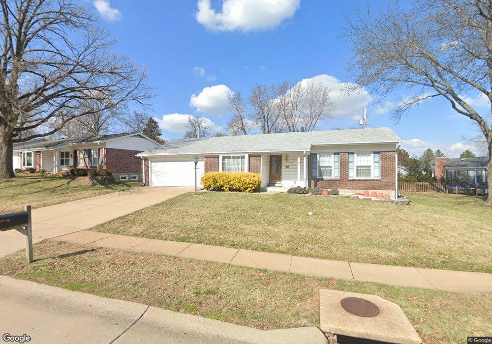
19 Foxhunt Dr Chesterfield, MO 63017
Estimated Value: $411,181 - $474,000
4
Beds
2
Baths
1,758
Sq Ft
$257/Sq Ft
Est. Value
About This Home
This home is located at 19 Foxhunt Dr, Chesterfield, MO 63017 and is currently estimated at $452,295, approximately $257 per square foot. 19 Foxhunt Dr is a home located in St. Louis County with nearby schools including Shenandoah Valley Elementary, Parkway Central Middle School, and Parkway Central High School.
Ownership History
Date
Name
Owned For
Owner Type
Purchase Details
Closed on
Oct 26, 2018
Sold by
Farkas Connie J and Farkas Connie K
Bought by
Farkas Connie J
Current Estimated Value
Home Financials for this Owner
Home Financials are based on the most recent Mortgage that was taken out on this home.
Original Mortgage
$66,000
Interest Rate
4.6%
Mortgage Type
New Conventional
Purchase Details
Closed on
Jun 9, 1997
Sold by
Farkas Oreon K and Farkas Connie K
Bought by
Revocable Trust Of Oreon K Farkas and Revocable Trust Of Connie K Farkas
Create a Home Valuation Report for This Property
The Home Valuation Report is an in-depth analysis detailing your home's value as well as a comparison with similar homes in the area
Home Values in the Area
Average Home Value in this Area
Purchase History
| Date | Buyer | Sale Price | Title Company |
|---|---|---|---|
| Farkas Connie J | -- | Freedom Title | |
| Revocable Trust Of Oreon K Farkas | -- | -- |
Source: Public Records
Mortgage History
| Date | Status | Borrower | Loan Amount |
|---|---|---|---|
| Closed | Farkas Connie J | $66,000 |
Source: Public Records
Tax History
| Year | Tax Paid | Tax Assessment Tax Assessment Total Assessment is a certain percentage of the fair market value that is determined by local assessors to be the total taxable value of land and additions on the property. | Land | Improvement |
|---|---|---|---|---|
| 2025 | $4,113 | $76,610 | $48,430 | $28,180 |
| 2024 | $4,113 | $62,090 | $25,880 | $36,210 |
| 2023 | $3,946 | $62,090 | $25,880 | $36,210 |
| 2022 | $3,588 | $51,360 | $25,880 | $25,480 |
| 2021 | $3,574 | $51,360 | $25,880 | $25,480 |
| 2020 | $3,313 | $45,700 | $23,010 | $22,690 |
| 2019 | $3,241 | $45,700 | $23,010 | $22,690 |
| 2018 | $3,484 | $45,580 | $23,010 | $22,570 |
| 2017 | $3,389 | $45,580 | $23,010 | $22,570 |
| 2016 | $3,031 | $38,700 | $16,640 | $22,060 |
Source: Public Records
Map
Nearby Homes
- 6 Pittsfield Ct
- 960 Chesterfield Pkwy E
- 810 Wellesley Place Dr
- 16 Conway Cove Dr
- 845 Wellesley Place Dr
- 904 Chesterfield Villas Cir
- 1318 Conway Oaks Dr
- 868 Wellesley Terrace Ln
- 596 Upper Conway Cir
- 6 Upper Conway Ln
- 15317 Oaktree Estates Dr
- 1009 Speckledwood Manor Ct
- 1204 Cedar Creek Rd
- 330 Calliope Place
- 27 Bonhomme Grove Ct
- 15355 Highcroft Dr
- 15000 S Outer 40 Rd
- 1511 Hampton Hall Dr Unit 19 & 20
- 1511 Hampton Hall Dr Unit 17
- 1525 Hampton Hall Dr Unit 5
- 40 White Plains Dr
- 5 Youngstown Ct
- 17 Foxhunt Dr
- 42 White Plains Dr
- 7 Youngstown Ct
- 46 White Plains Dr
- 16 Foxhunt Dr
- 48 White Plains Dr
- 44 White Plains Dr
- 14 Foxhunt Dr
- 47 White Plains Dr
- 45 White Plains Dr
- 50 White Plains Dr
- 15 Foxhunt Dr
- 4 Youngstown Ct
- 49 White Plains Dr
- 36 White Plains Dr
- 8 Youngstown Ct
- 12 Foxhunt Dr
- 43 White Plains Dr
Your Personal Tour Guide
Ask me questions while you tour the home.