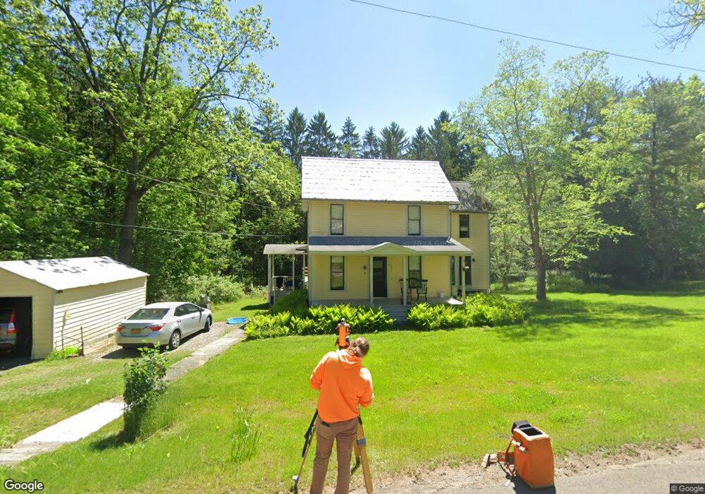
19 High St Alfred, NY 14802
Estimated Value: $211,601 - $271,000
4
Beds
2
Baths
2,130
Sq Ft
$108/Sq Ft
Est. Value
About This Home
This home is located at 19 High St, Alfred, NY 14802 and is currently estimated at $230,650, approximately $108 per square foot. 19 High St is a home located in Allegany County with nearby schools including Alfred-Almond Elementary School and Alfred-Almond Junior/Senior High School.
Ownership History
Date
Name
Owned For
Owner Type
Purchase Details
Closed on
Jan 12, 2023
Sold by
Mcinnes Andrew and Mcinnies Mary D
Bought by
Thwing Jennie E and Horner Eric R
Current Estimated Value
Home Financials for this Owner
Home Financials are based on the most recent Mortgage that was taken out on this home.
Original Mortgage
$132,500
Outstanding Balance
$128,319
Interest Rate
6.49%
Mortgage Type
Purchase Money Mortgage
Estimated Equity
$102,331
Purchase Details
Closed on
Sep 4, 2002
Sold by
Fischer Rosemary
Bought by
Mcinnes Andrew
Create a Home Valuation Report for This Property
The Home Valuation Report is an in-depth analysis detailing your home's value as well as a comparison with similar homes in the area
Home Values in the Area
Average Home Value in this Area
Purchase History
| Date | Buyer | Sale Price | Title Company |
|---|---|---|---|
| Thwing Jennie E | $182,500 | None Available | |
| Mcinnes Andrew | $85,000 | Patricia K. Fogarty |
Source: Public Records
Mortgage History
| Date | Status | Borrower | Loan Amount |
|---|---|---|---|
| Open | Thwing Jennie E | $132,500 |
Source: Public Records
Tax History
| Year | Tax Paid | Tax Assessment Tax Assessment Total Assessment is a certain percentage of the fair market value that is determined by local assessors to be the total taxable value of land and additions on the property. | Land | Improvement |
|---|---|---|---|---|
| 2024 | $7,100 | $106,495 | $10,355 | $96,140 |
| 2023 | $6,986 | $106,495 | $10,355 | $96,140 |
| 2022 | $6,798 | $106,495 | $10,355 | $96,140 |
| 2021 | $5,145 | $106,495 | $10,355 | $96,140 |
| 2020 | $6,118 | $106,495 | $10,355 | $96,140 |
| 2019 | $6,134 | $106,495 | $10,355 | $96,140 |
| 2018 | $6,134 | $106,495 | $10,355 | $96,140 |
| 2017 | $6,100 | $112,100 | $10,900 | $101,200 |
| 2016 | $5,962 | $112,100 | $10,900 | $101,200 |
| 2015 | -- | $112,100 | $10,900 | $101,200 |
| 2014 | -- | $112,100 | $10,900 | $101,200 |
Source: Public Records
Map
Nearby Homes
- 1 Reynolds St
- 3 N Main St
- 82 W University St
- 28 Hillcrest Dr
- Vl Unit McAndrews Road LotWP
- Vl Unit McAndrews Road LotWP
- Vl Unit McAndrews Road LotWP
- Vl Lot Unit 7 McAndrews Road Lot
- 6306 Shaw Rd
- Lot 9 Mc Andrews Rd
- Lot 7 Mc Andrews Rd
- 6521 Whitford Rd
- 0 Clark Road Extension
- 0 Clark Rd
- 568 Buckley Ln
- 2815 Stuck Hill Rd
- 422 McHenry Valley Rd
- 386 McHenry Valley Rd
- 7 McHenry Valley Extension
- 3 Crescent Place
Your Personal Tour Guide
Ask me questions while you tour the home.