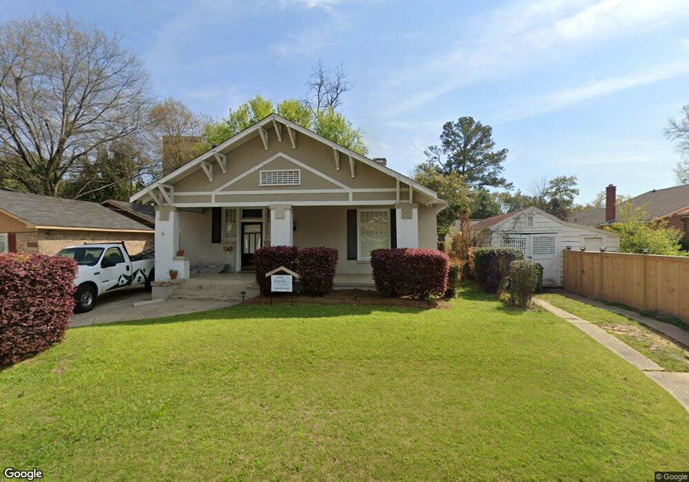
1900 Hill St Columbus, GA 31906
Wynnton Village NeighborhoodEstimated Value: $217,000 - $269,000
About This Home
This home is located at 1900 Hill St, Columbus, GA 31906 and is currently estimated at $247,863, approximately $98 per square foot. 1900 Hill St is a home located in Muscogee County with nearby schools including Richards Middle School, Hardaway High School, and Wynnton Elementary School.
Ownership History
We collect this data history from publicly available records. To have your information removed, we recommend requesting removal directly through your county’s website.
Purchase Details
Purchase Details
Purchase Details
Home Financials for this Owner
Home Financials are based on the most recent Mortgage that was taken out on this home.Home Values in the Area
Average Home Value in this Area
Purchase History
We collect this data history from publicly available records. To have your information removed, we recommend requesting removal directly through your county’s website.
| Date | Buyer | Sale Price | Title Company |
|---|---|---|---|
| $106,000 | -- | ||
| $130,278 | -- | ||
| $165,000 | -- |
Mortgage History
We collect this data history from publicly available records. To have your information removed, we recommend requesting removal directly through your county’s website.
| Date | Status | Borrower | Loan Amount |
|---|---|---|---|
| Previous Owner | $168,547 |
Tax History
We collect this data history from publicly available records. To have your information removed, we recommend requesting removal directly through your county’s website.
| Year | Tax Paid | Tax Assessment Tax Assessment Total Assessment is a certain percentage of the fair market value that is determined by local assessors to be the total taxable value of land and additions on the property. | Land | Improvement |
|---|---|---|---|---|
| 2025 | $3,201 | $81,776 | $7,828 | $73,948 |
| 2024 | $3,201 | $81,776 | $7,828 | $73,948 |
| 2023 | $3,221 | $81,776 | $7,828 | $73,948 |
| 2022 | $2,170 | $53,136 | $7,828 | $45,308 |
| 2021 | $2,363 | $57,884 | $7,828 | $50,056 |
| 2020 | $2,364 | $57,884 | $7,828 | $50,056 |
| 2019 | $2,372 | $57,884 | $7,828 | $50,056 |
| 2018 | $2,372 | $57,884 | $7,828 | $50,056 |
| 2017 | $2,475 | $59,884 | $9,784 | $50,100 |
| 2016 | $2,175 | $66,001 | $10,003 | $55,998 |
| 2015 | $2,178 | $66,001 | $10,003 | $55,998 |
| 2014 | $2,729 | $66,001 | $10,003 | $55,998 |
| 2013 | -- | $83,961 | $10,003 | $73,958 |
Map
- 1205 Munro Ave
- 1242 18th Ave
- 1261 Owsley Ave
- 1215 18th Ave
- 1254 18th Ave
- 1702 Richards St
- 1710 Boulevard St
- 2551 Wynnton Rd
- 1255 Cedar Ave Unit 5
- 1500 E Dinglewood Dr
- 1228 Cedar Ave
- 957 Overlook Dr
- 1427 16th Ave
- 2134 13th St
- 1620 Springer St
- 1103 Bryan Ave
- 2217 13th St
- 2207 Bell St
- 1007 Blandford Ave
- 2223 15th St
- 1908 Hill St
- 1910 Hill St
- 1904 Hill St
- 1912 Hill St
- 1915 12th St
- 1917 12th St
- 1919 12th St Unit B
- 1919 12th St
- 1914 Hill St
- 1222 Owsley Ave
- 1218 Owsley Ave
- 1210 Owsley Ave
- 1905 12th St
- 1905-1907 12th St Unit 1907
- 1905-1907 12th St Unit 1905
- 1905 Hill St
- 1901 Hill St
- 1913 Hill St
- 1208 Owsley Ave
- 1211 Munro Ave
Ask me questions while you tour the home.