
Seller's Agent in 2026
Tracy Evans
Coldwell Banker Bain
(206) 658-5762
36 in this area
39 Total Sales
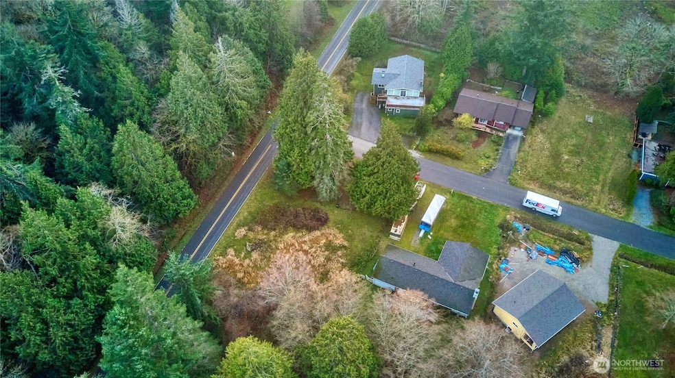
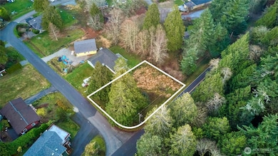
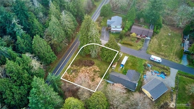
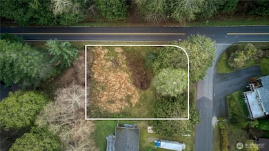
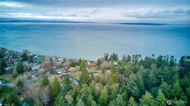
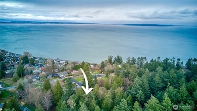
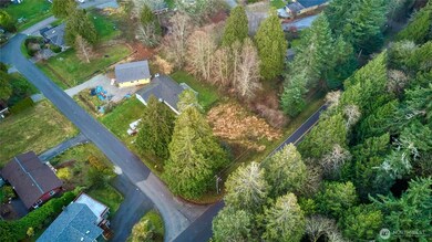
Gorgeous view property at the corner of Johnson Rd and Donegal Dr. With just a short walk to Maple Beach! This 9,092 square foot lot has water installed and connected; and electric on-site. This is one of the few lots in Michael Palisades that allows for a 2-story home. Included is the Whatcom County Building Permit #SFR 2024-00134 (11/27/24) for a 3-bedroom view home. If you want to build your dream home in one of the most prestigious neighborhoods in Point Roberts, this is it. Located just minutes from the US/Canada border, with views of Vancouver's Skyline, Mountains and Boundary Bay. Whatcom County 2025 Land Market Value for the property is $141,926. Vancouver, BC and Bellingham, WA are close by. Don't miss out on this opportunity!
Last Agent to Sell the Property
Coldwell Banker Bain License #136589 Listed on: 12/23/2025
Source: Northwest Multiple Listing Service (NWMLS)
MLS#: 2460999
| Date | Type | Sale Price | Title Company |
|---|---|---|---|
| Warranty Deed | $145,000 | Fidelity National Title | |
| Warranty Deed | $45,000 | Chicago Title Company Of Wa | |
| Quit Claim Deed | -- | Accommodation | |
| Quit Claim Deed | -- | Whatcom Land Title | |
| Warranty Deed | $129,280 | Whatcom Land Title | |
| Warranty Deed | $55,000 | Whatcom Land Title |
| Date | Status | Loan Amount | Loan Type |
|---|---|---|---|
| Previous Owner | $73,000 | Purchase Money Mortgage |
| Date | Event | Price | List to Sale | Price per Sq Ft |
|---|---|---|---|---|
| 01/26/2026 01/26/26 | Sold | $145,000 | -2.7% | -- |
| 01/04/2026 01/04/26 | Pending | -- | -- | -- |
| 12/23/2025 12/23/25 | For Sale | $149,000 | -- | -- |
Seller's Agent in 2026
Tracy Evans
Coldwell Banker Bain
(206) 658-5762
36 in this area
39 Total Sales
Source: Northwest Multiple Listing Service (NWMLS)
MLS Number: 2460999
APN: 415335-470008-0000
Disclaimer: Certain information contained herein is derived from information provided by parties other than Homes.com. All information provided is deemed reliable, but is not guaranteed to be accurate and should be independently verified.
![]() All data is obtained from various sources and may not have been verified by broker or MLS GRID. Supplied Open House Information is subject to change without notice. All information should be independently reviewed and verified for accuracy. Properties may or may not be listed by the office/agent presenting the information. Listing information is provided by the Northwest Multiple Listing Service (NWMLS). Property information is based on available data that may include MLS information, county records, and other sources. Listings marked with the 3 tree icon and provided by NWMLS. All properties are subject to prior sale or withdrawal. IDX information is provided exclusively for consumers’ personal noncommercial use, that it may not be used for any purpose other than to identify prospective properties consumers may be interested in purchasing, that the data is deemed reliable but is not guaranteed by MLS GRID. ©2026 NWMLS.
All data is obtained from various sources and may not have been verified by broker or MLS GRID. Supplied Open House Information is subject to change without notice. All information should be independently reviewed and verified for accuracy. Properties may or may not be listed by the office/agent presenting the information. Listing information is provided by the Northwest Multiple Listing Service (NWMLS). Property information is based on available data that may include MLS information, county records, and other sources. Listings marked with the 3 tree icon and provided by NWMLS. All properties are subject to prior sale or withdrawal. IDX information is provided exclusively for consumers’ personal noncommercial use, that it may not be used for any purpose other than to identify prospective properties consumers may be interested in purchasing, that the data is deemed reliable but is not guaranteed by MLS GRID. ©2026 NWMLS.
Based on information submitted to the MLS GRID
Ask me questions while you tour the home.