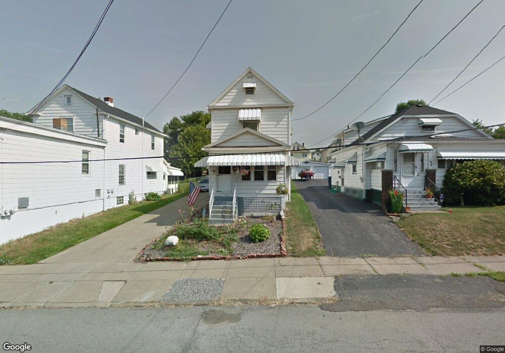
192 Robinson Rd Campbell, OH 44405
Estimated Value: $49,000 - $102,000
3
Beds
2
Baths
1,408
Sq Ft
$56/Sq Ft
Est. Value
About This Home
This home is located at 192 Robinson Rd, Campbell, OH 44405 and is currently estimated at $78,223, approximately $55 per square foot. 192 Robinson Rd is a home located in Mahoning County with nearby schools including Campbell Elementary School, Memorial High School, and Northeast Ohio Impact Academy.
Ownership History
Date
Name
Owned For
Owner Type
Purchase Details
Closed on
May 26, 2023
Bought by
M & L Housing Llc
Current Estimated Value
Purchase Details
Closed on
Aug 30, 2022
Bought by
Patellis Salena M
Purchase Details
Closed on
Mar 4, 2008
Sold by
Wells Fargo Bank Na
Bought by
Malutic Stephen M
Purchase Details
Closed on
Apr 4, 2007
Sold by
Thigpen Sylvia
Bought by
Wells Fargo Bank Na
Purchase Details
Closed on
Mar 21, 2005
Sold by
Urchak John and Cifalde Linda
Bought by
Thigpen Sylvia
Home Financials for this Owner
Home Financials are based on the most recent Mortgage that was taken out on this home.
Original Mortgage
$57,600
Interest Rate
9.3%
Mortgage Type
Purchase Money Mortgage
Purchase Details
Closed on
Aug 13, 1993
Bought by
Simon Sophie and Simon Michele
Create a Home Valuation Report for This Property
The Home Valuation Report is an in-depth analysis detailing your home's value as well as a comparison with similar homes in the area
Home Values in the Area
Average Home Value in this Area
Purchase History
| Date | Buyer | Sale Price | Title Company |
|---|---|---|---|
| M & L Housing Llc | -- | -- | |
| Patellis Salena M | -- | -- | |
| Malutic Stephen M | $14,000 | Title First Agency | |
| Wells Fargo Bank Na | $32,000 | None Available | |
| Thigpen Sylvia | $64,000 | Foundation Title Agency Ltd | |
| Simon Sophie | -- | -- |
Source: Public Records
Mortgage History
| Date | Status | Borrower | Loan Amount |
|---|---|---|---|
| Previous Owner | Thigpen Sylvia | $57,600 | |
| Closed | Thigpen Sylvia | $3,200 |
Source: Public Records
Tax History
| Year | Tax Paid | Tax Assessment Tax Assessment Total Assessment is a certain percentage of the fair market value that is determined by local assessors to be the total taxable value of land and additions on the property. | Land | Improvement |
|---|---|---|---|---|
| 2025 | $474 | $8,800 | $290 | $8,510 |
| 2024 | $474 | $8,800 | $290 | $8,510 |
| 2023 | $469 | $8,800 | $290 | $8,510 |
| 2022 | $289 | $4,520 | $290 | $4,230 |
| 2021 | $271 | $4,520 | $290 | $4,230 |
| 2020 | $275 | $4,520 | $290 | $4,230 |
| 2019 | $266 | $3,850 | $290 | $3,560 |
| 2018 | $272 | $3,850 | $290 | $3,560 |
| 2017 | $287 | $3,850 | $290 | $3,560 |
| 2016 | $304 | $4,620 | $290 | $4,330 |
| 2015 | $298 | $4,620 | $290 | $4,330 |
| 2014 | $297 | $4,620 | $290 | $4,330 |
| 2013 | $292 | $4,620 | $290 | $4,330 |
Source: Public Records
Map
Nearby Homes
- 204 Tremble Ave
- 130 12th St
- 459 Tenney Ave
- 127 Blackburn St
- 374 Tenney Ave
- 0 Penhale Ave
- 664 Tenney Ave
- 190 10th St
- 151 Regent St
- 121 Princess St
- 159 Piccadilly St
- 165 Piccadilly St
- 97 Rosary Dr
- 190 Struthers Liberty Rd
- 114 Penhale Ave
- 611 Matawan Dr
- 3307 Upland Ave
- 330 Sanderson Ave
- 291 Struthers Liberty Rd
- 3343 Lawnview Ave
Your Personal Tour Guide
Ask me questions while you tour the home.