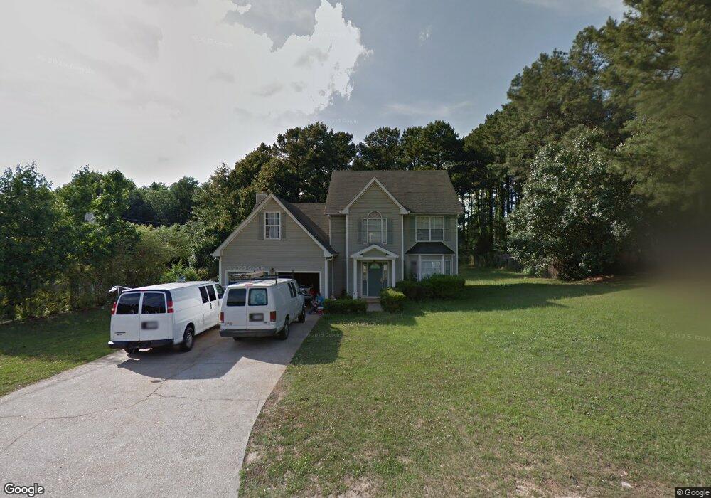
1920 Rocksram Dr Unit 1 Buford, GA 30519
Estimated Value: $400,683 - $429,000
3
Beds
3
Baths
2,508
Sq Ft
$165/Sq Ft
Est. Value
About This Home
This home is located at 1920 Rocksram Dr Unit 1, Buford, GA 30519 and is currently estimated at $413,421, approximately $164 per square foot. 1920 Rocksram Dr Unit 1 is a home located in Gwinnett County with nearby schools including Woodward Mill Elementary School, Twin Rivers Middle School, and Mountain View High School.
Ownership History
Date
Name
Owned For
Owner Type
Purchase Details
Closed on
Aug 7, 2003
Sold by
Booker James B
Bought by
Pacheco Julio
Current Estimated Value
Home Financials for this Owner
Home Financials are based on the most recent Mortgage that was taken out on this home.
Original Mortgage
$132,600
Outstanding Balance
$57,832
Interest Rate
5.72%
Mortgage Type
New Conventional
Estimated Equity
$355,589
Purchase Details
Closed on
Mar 12, 1997
Sold by
Myer Robert J and Pothier Renee E
Bought by
Booker James B
Create a Home Valuation Report for This Property
The Home Valuation Report is an in-depth analysis detailing your home's value as well as a comparison with similar homes in the area
Home Values in the Area
Average Home Value in this Area
Purchase History
| Date | Buyer | Sale Price | Title Company |
|---|---|---|---|
| Pacheco Julio | $156,000 | -- | |
| Booker James B | $117,500 | -- |
Source: Public Records
Mortgage History
| Date | Status | Borrower | Loan Amount |
|---|---|---|---|
| Open | Pacheco Julio | $132,600 | |
| Closed | Booker James B | $0 |
Source: Public Records
Tax History
| Year | Tax Paid | Tax Assessment Tax Assessment Total Assessment is a certain percentage of the fair market value that is determined by local assessors to be the total taxable value of land and additions on the property. | Land | Improvement |
|---|---|---|---|---|
| 2025 | $7,581 | $204,800 | $23,920 | $180,880 |
| 2024 | $5,920 | $155,720 | $28,000 | $127,720 |
| 2023 | $5,920 | $152,240 | $28,000 | $124,240 |
| 2022 | $4,107 | $105,680 | $16,000 | $89,680 |
| 2021 | $3,803 | $95,840 | $16,000 | $79,840 |
| 2020 | $3,500 | $95,840 | $16,000 | $79,840 |
| 2019 | $3,500 | $90,560 | $16,000 | $74,560 |
| 2018 | $3,346 | $86,120 | $16,000 | $70,120 |
| 2016 | $2,786 | $69,640 | $12,400 | $57,240 |
| 2015 | $2,435 | $58,920 | $8,400 | $50,520 |
| 2014 | -- | $58,920 | $8,400 | $50,520 |
Source: Public Records
Map
Nearby Homes
- 2317 Rocksram Ct
- 2375 Rock Springs Rd
- 2242 Rocksram Ct
- 2220 Sunny Hill Rd
- 2199 Sunny Hill Rd
- 2159 Sunny Hill Rd
- 1948 Trestlebrook Way Unit 3
- 1521 Jami Hollow Way
- 2226 Sun Valley Ct
- 2510 Sunny Hill Rd
- 1845 Hanover West Dr
- 1876 Hanover West Dr
- 1677 Old Peachtree Rd
- 1975 Wynfield Point Dr
- 2012 Arbor Springs Way
- 2710 Dreycott Ln
- 2053 Arbor Springs Way
- 2712 Dreycott Ln
- 2724 Dreycott Ln
- 2725 Dreycott Ln
- 1930 Rocksram Dr Unit 1
- 1925 Rocksram Dr
- 1915 Rocksram Dr Unit 1
- 1900 Rocksram Dr
- 1940 Rocksram Dr Unit 1
- 1935 Rocksram Dr
- 1919 Manor Oak Ln Unit 1
- 1905 Rocksram Dr
- 1929 Manor Oak Ln
- 1909 Manor Oak Ln Unit 1
- 1950 Rocksram Dr Unit 2
- 1890 Rocksram Dr Unit 8 / A
- 1890 Rocksram Dr
- 1945 Rocksram Dr Unit 1
- 1939 Manor Oak Ln
- 1899 Manor Oak Ln
- 1895 Rocksram Dr Unit 1
- 1949 Manor Oak Ln Unit 18
- 1949 Manor Oak Ln
- 1889 Manor Oak Ln Unit 1
Your Personal Tour Guide
Ask me questions while you tour the home.