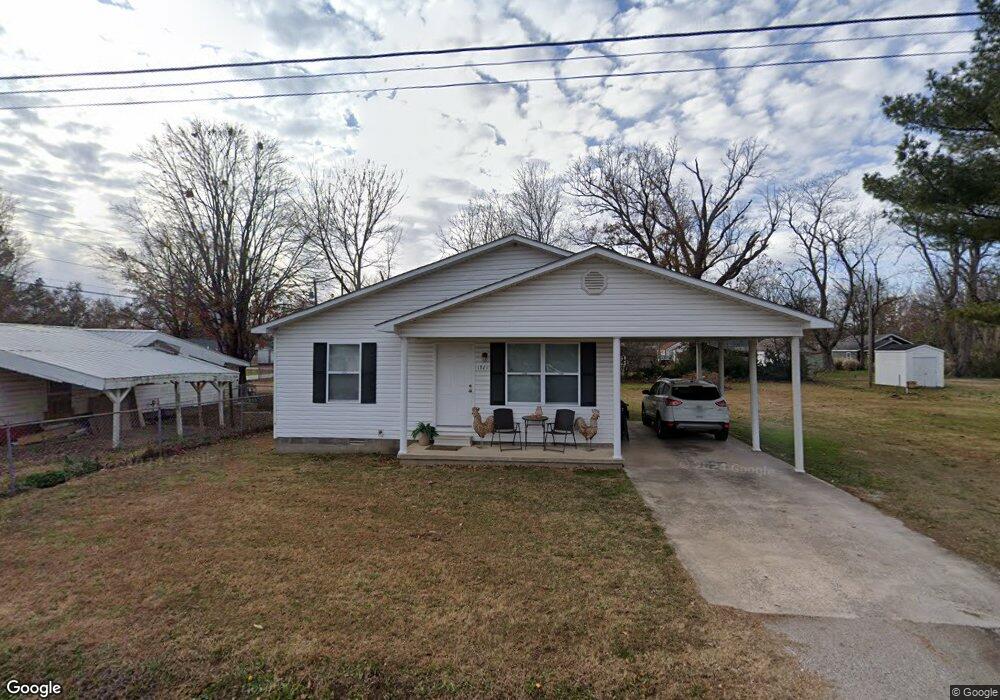
1921 Wilson St Poplar Bluff, MO 63901
Estimated Value: $102,000 - $125,000
3
Beds
1
Bath
1,120
Sq Ft
$105/Sq Ft
Est. Value
About This Home
This home is located at 1921 Wilson St, Poplar Bluff, MO 63901 and is currently estimated at $117,987, approximately $105 per square foot. 1921 Wilson St is a home located in Butler County with nearby schools including Eugene Field Elementary School, Poplar Bluff Fifth & Sixth Grade Center, and Poplar Bluff Junior High School.
Ownership History
Date
Name
Owned For
Owner Type
Purchase Details
Closed on
Mar 24, 2020
Sold by
Roach Bennie and Roach Beverly
Bought by
Bph Properties Llc
Current Estimated Value
Home Financials for this Owner
Home Financials are based on the most recent Mortgage that was taken out on this home.
Original Mortgage
$121,500
Outstanding Balance
$83,937
Interest Rate
3.4%
Mortgage Type
Future Advance Clause Open End Mortgage
Estimated Equity
$34,050
Purchase Details
Closed on
Feb 17, 2005
Sold by
Hart Kathy Sue
Bought by
Roach Bennie and Roach Beverly
Create a Home Valuation Report for This Property
The Home Valuation Report is an in-depth analysis detailing your home's value as well as a comparison with similar homes in the area
Home Values in the Area
Average Home Value in this Area
Purchase History
| Date | Buyer | Sale Price | Title Company |
|---|---|---|---|
| Bph Properties Llc | -- | None Available | |
| Roach Bennie | -- | -- |
Source: Public Records
Mortgage History
| Date | Status | Borrower | Loan Amount |
|---|---|---|---|
| Open | Bph Properties Llc | $121,500 |
Source: Public Records
Tax History Compared to Growth
Tax History
| Year | Tax Paid | Tax Assessment Tax Assessment Total Assessment is a certain percentage of the fair market value that is determined by local assessors to be the total taxable value of land and additions on the property. | Land | Improvement |
|---|---|---|---|---|
| 2024 | $691 | $14,310 | $0 | $0 |
| 2023 | $691 | $14,310 | $0 | $0 |
| 2022 | $667 | $13,830 | $0 | $0 |
| 2021 | $667 | $13,830 | $0 | $0 |
| 2020 | $676 | $13,830 | $0 | $0 |
| 2019 | $676 | $13,830 | $0 | $0 |
| 2018 | $676 | $13,830 | $0 | $0 |
| 2017 | -- | $13,830 | $0 | $0 |
| 2016 | -- | $13,830 | $0 | $0 |
| 2015 | -- | $13,830 | $0 | $0 |
| 2014 | -- | $12,870 | $0 | $0 |
| 2012 | $548 | $12,870 | $0 | $0 |
Source: Public Records
Map
Nearby Homes
- 318 E Henry St
- 110 Hampton Ct
- 146 Hampton Ct
- 404 E Henry St
- 1910 Arkansas Ave
- 2011 Arkansas Ave
- 2015 Arkansas Ave
- 243 Hampton Ct
- 251 Hampton Ct
- 231 Hampton Ct
- 2318 Arkansas Ave
- 439 E Henry St
- 1708 Kentucky Ave
- 1905 Kentucky Ave
- 2347 Arkansas Ave
- 622 Nickey St
- 314 S E St
- 712 Nickey St
- 2335 Cheshire Blvd
- 533 Short A St
- 1923 Wilson St
- 1915 Wilson St
- 1916 Wilson St
- 1912 Wilson St
- 226 E Henry St
- 1903 Wilson St
- 1912 Woodrow St
- 1920 Woodrow St
- 1910 Woodrow St
- 302 E Henry St
- 1908 Woodrow St
- 218 E Henry St
- 1900 Wilson St
- 325 E Henry St
- 210 E Henry St
- 1906 Woodrow St
- 310 E Henry St
- 327 E Henry St
- 1814 Wilson St
- 202 E Henry St