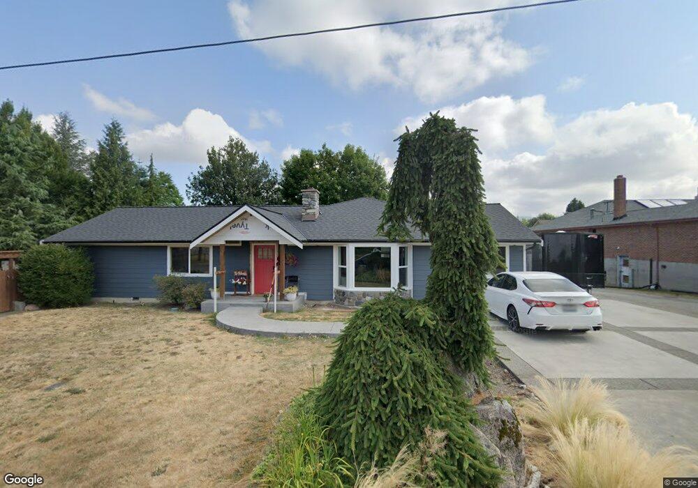
1929 Washington Ave Enumclaw, WA 98022
Estimated Value: $536,000 - $665,000
4
Beds
2
Baths
1,930
Sq Ft
$318/Sq Ft
Est. Value
About This Home
This home is located at 1929 Washington Ave, Enumclaw, WA 98022 and is currently estimated at $613,786, approximately $318 per square foot. 1929 Washington Ave is a home located in King County with nearby schools including Byron Kibler Elementary School, Enumclaw Middle School, and Enumclaw Senior High School.
Ownership History
Date
Name
Owned For
Owner Type
Purchase Details
Closed on
Aug 9, 1999
Sold by
Tarantola Investment Llc
Bought by
Palensky Willie Joe Allen
Current Estimated Value
Home Financials for this Owner
Home Financials are based on the most recent Mortgage that was taken out on this home.
Original Mortgage
$123,500
Outstanding Balance
$35,628
Interest Rate
7.7%
Estimated Equity
$578,158
Purchase Details
Closed on
Jun 4, 1999
Sold by
Baumgardner Dennis Maaele and Baumgardner Melissa Lynn
Bought by
Tarantola Investment Llc
Create a Home Valuation Report for This Property
The Home Valuation Report is an in-depth analysis detailing your home's value as well as a comparison with similar homes in the area
Home Values in the Area
Average Home Value in this Area
Purchase History
| Date | Buyer | Sale Price | Title Company |
|---|---|---|---|
| Palensky Willie Joe Allen | $130,000 | Fidelity National Title | |
| Tarantola Investment Llc | $89,820 | Transnation Title Insurance |
Source: Public Records
Mortgage History
| Date | Status | Borrower | Loan Amount |
|---|---|---|---|
| Open | Palensky Willie Joe Allen | $123,500 |
Source: Public Records
Tax History
| Year | Tax Paid | Tax Assessment Tax Assessment Total Assessment is a certain percentage of the fair market value that is determined by local assessors to be the total taxable value of land and additions on the property. | Land | Improvement |
|---|---|---|---|---|
| 2024 | $5,778 | $602,000 | $188,000 | $414,000 |
| 2023 | $4,665 | $449,000 | $162,000 | $287,000 |
| 2022 | $4,176 | $513,000 | $186,000 | $327,000 |
| 2021 | $3,933 | $416,000 | $161,000 | $255,000 |
| 2020 | $3,590 | $357,000 | $124,000 | $233,000 |
| 2018 | $3,580 | $323,000 | $114,000 | $209,000 |
| 2017 | $3,171 | $292,000 | $104,000 | $188,000 |
| 2016 | $3,028 | $267,000 | $96,000 | $171,000 |
| 2015 | $2,949 | $251,000 | $91,000 | $160,000 |
| 2014 | -- | $234,000 | $90,000 | $144,000 |
| 2013 | -- | $180,000 | $72,000 | $108,000 |
Source: Public Records
Map
Nearby Homes
- 1966 Wilson Ave
- 1730 Hillcrest Ave
- 1705 Marshall Ave
- 1975 Wilson Ave
- 2921 Frederickson St
- 1722 Harding St
- 1720 Garfield St Unit 4
- 1318 Lafromboise St
- 1107 Griffin Ave
- 1355 Mchugh Ave
- 0 xx 266th Ave SE
- 42801 264th Ave SE
- 2881 Initial Ave
- 1234 Lincoln Ave Unit A
- 1234 Lincoln Ave Unit B
- 2054 Roosevelt Ave
- 111 Chinook Ave
- 27008 SE & 27012 432nd St
- 1909 Highpoint St
- 431 Rainier Ave
- 2620 Moore St
- 1910 James St
- 1940 James St
- 1941 Division St
- 1926 Washington Ave
- 2002 James St
- 1902 Washington Ave
- 2014 James St
- 1949 Division St
- 1850 Washington Ave
- 1837 Washington Ave
- 1970 Kibler Ave
- 2024 James St
- 1959 Division St
- 1929 James St
- 1849 Marshall Ave
- 1966 Kibler Ave
- 1830 Washington Ave
- 1926 Hillcrest Ave
- 1969 Division St
Your Personal Tour Guide
Ask me questions while you tour the home.