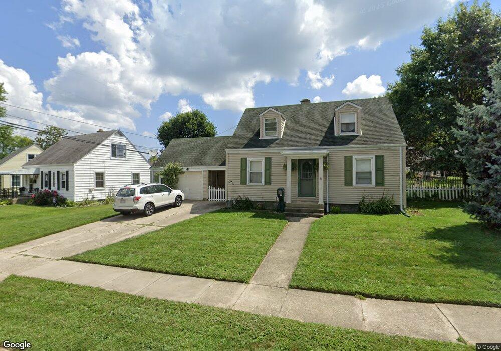
1932 Malcom Dr Dayton, OH 45420
Estimated Value: $168,000 - $187,000
4
Beds
1
Bath
1,008
Sq Ft
$176/Sq Ft
Est. Value
About This Home
This home is located at 1932 Malcom Dr, Dayton, OH 45420 and is currently estimated at $177,335, approximately $175 per square foot. 1932 Malcom Dr is a home located in Montgomery County with nearby schools including Greenmont Elementary School, Kettering Middle School, and Kettering Fairmont High School.
Ownership History
Date
Name
Owned For
Owner Type
Purchase Details
Closed on
Aug 23, 2017
Sold by
Jennings Richard
Bought by
Page Samuel and Taylor Alyssa
Current Estimated Value
Home Financials for this Owner
Home Financials are based on the most recent Mortgage that was taken out on this home.
Original Mortgage
$85,845
Outstanding Balance
$71,253
Interest Rate
4.03%
Mortgage Type
New Conventional
Estimated Equity
$106,082
Purchase Details
Closed on
Mar 21, 2013
Sold by
Estate Of Helen Jennings
Bought by
Jennings Richard
Create a Home Valuation Report for This Property
The Home Valuation Report is an in-depth analysis detailing your home's value as well as a comparison with similar homes in the area
Home Values in the Area
Average Home Value in this Area
Purchase History
| Date | Buyer | Sale Price | Title Company |
|---|---|---|---|
| Page Samuel | $88,500 | None Available | |
| Jennings Richard | -- | None Available |
Source: Public Records
Mortgage History
| Date | Status | Borrower | Loan Amount |
|---|---|---|---|
| Open | Page Samuel | $85,845 |
Source: Public Records
Tax History
| Year | Tax Paid | Tax Assessment Tax Assessment Total Assessment is a certain percentage of the fair market value that is determined by local assessors to be the total taxable value of land and additions on the property. | Land | Improvement |
|---|---|---|---|---|
| 2025 | $2,885 | $44,450 | $11,010 | $33,440 |
| 2024 | $2,804 | $44,450 | $11,010 | $33,440 |
| 2023 | $2,804 | $44,450 | $11,010 | $33,440 |
| 2022 | $2,484 | $31,030 | $7,700 | $23,330 |
| 2021 | $2,301 | $31,030 | $7,700 | $23,330 |
| 2020 | $2,308 | $31,030 | $7,700 | $23,330 |
| 2019 | $2,886 | $34,510 | $7,700 | $26,810 |
| 2018 | $2,901 | $34,510 | $7,700 | $26,810 |
| 2017 | $2,741 | $34,510 | $7,700 | $26,810 |
| 2016 | $1,796 | $30,260 | $7,700 | $22,560 |
| 2015 | $1,718 | $30,260 | $7,700 | $22,560 |
| 2014 | $1,718 | $30,260 | $7,700 | $22,560 |
| 2012 | -- | $31,310 | $8,400 | $22,910 |
Source: Public Records
Map
Nearby Homes
- 2291 Patterson Rd
- 1534 Horlacher Ave
- 1513 Horlacher Ave
- 1421 Flesher Ave
- 2112 Patterson Rd
- 2817 Kennedy Ave
- 1529 Watervliet Ave
- 2040 Courtland Ave
- 2216 Culver Ave
- 1618 Briedweng Ave Unit 1616
- 5123 Haverfield Rd
- 2929 Wayland Ave
- 2908 Hazel Ave
- 2904 Kingston Ave
- 4883 Rainier Dr
- 2408 Homeland Ct
- 1409 Highview Ave
- 1104 Chelsea Ave
- 4517 Debra Ave
- 1020 Weng Ave
- 1938 Craig Dr
- 1920 Malcom Dr
- 1942 Craig Dr
- 1944 Malcom Dr
- 1931 Malcom Dr
- 1935 Malcom Dr
- 1927 Malcom Dr
- 1914 Malcom Dr
- 1939 Malcom Dr
- 1937 E Bataan Dr
- 1923 Malcom Dr
- 1946 Craig Dr
- 1945 Craig Dr
- 1941 E Bataan Dr
- 1933 E Bataan Dr
- 1947 Malcom Dr
- 1948 Malcom Dr
- 1919 Malcom Dr
- 1925 E Bataan Dr
- 1945 E Bataan Dr
Your Personal Tour Guide
Ask me questions while you tour the home.