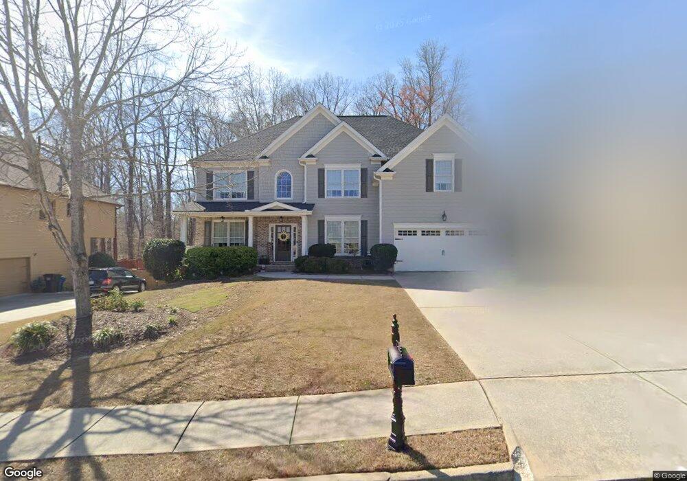
1938 Mapmaker Dr Unit 3 Dacula, GA 30019
Estimated Value: $551,558 - $635,000
5
Beds
4
Baths
3,252
Sq Ft
$180/Sq Ft
Est. Value
About This Home
This home is located at 1938 Mapmaker Dr Unit 3, Dacula, GA 30019 and is currently estimated at $586,140, approximately $180 per square foot. 1938 Mapmaker Dr Unit 3 is a home located in Gwinnett County with nearby schools including Fort Daniel Elementary School, Frank N. Osborne Middle School, and Mill Creek High School.
Ownership History
Date
Name
Owned For
Owner Type
Purchase Details
Closed on
Oct 9, 2020
Sold by
Hill William Barrett
Bought by
Hill William Barrett and Hill Tami L
Current Estimated Value
Purchase Details
Closed on
Jul 7, 2005
Sold by
Hill Tami L
Bought by
Hill William B
Home Financials for this Owner
Home Financials are based on the most recent Mortgage that was taken out on this home.
Original Mortgage
$323,000
Interest Rate
6.75%
Mortgage Type
New Conventional
Purchase Details
Closed on
Jul 30, 2004
Sold by
W D Thomas Homes Inc
Bought by
Hill William B and Hill Tami
Home Financials for this Owner
Home Financials are based on the most recent Mortgage that was taken out on this home.
Original Mortgage
$306,500
Interest Rate
6.55%
Mortgage Type
New Conventional
Purchase Details
Closed on
Jan 14, 2004
Sold by
Key Property Mgmt Svcs Inc
Bought by
W D Thomas Homes Inc
Create a Home Valuation Report for This Property
The Home Valuation Report is an in-depth analysis detailing your home's value as well as a comparison with similar homes in the area
Home Values in the Area
Average Home Value in this Area
Purchase History
| Date | Buyer | Sale Price | Title Company |
|---|---|---|---|
| Hill William Barrett | -- | -- | |
| Hill William B | -- | -- | |
| Hill William B | $306,500 | -- | |
| W D Thomas Homes Inc | $259,500 | -- |
Source: Public Records
Mortgage History
| Date | Status | Borrower | Loan Amount |
|---|---|---|---|
| Previous Owner | Hill William B | $323,000 | |
| Previous Owner | Hill William B | $306,500 |
Source: Public Records
Tax History
| Year | Tax Paid | Tax Assessment Tax Assessment Total Assessment is a certain percentage of the fair market value that is determined by local assessors to be the total taxable value of land and additions on the property. | Land | Improvement |
|---|---|---|---|---|
| 2025 | $8,110 | $241,480 | $44,000 | $197,480 |
| 2024 | $8,162 | $235,960 | $47,200 | $188,760 |
| 2023 | $8,162 | $218,200 | $47,200 | $171,000 |
| 2022 | $6,995 | $193,360 | $41,200 | $152,160 |
| 2021 | $5,324 | $143,960 | $29,400 | $114,560 |
| 2020 | $5,358 | $143,960 | $29,400 | $114,560 |
| 2019 | $4,410 | $143,960 | $29,400 | $114,560 |
| 2018 | $4,781 | $132,760 | $25,920 | $106,840 |
| 2016 | $4,297 | $118,400 | $21,600 | $96,800 |
| 2015 | $3,877 | $105,240 | $20,000 | $85,240 |
| 2014 | $3,797 | $102,400 | $20,000 | $82,400 |
Source: Public Records
Map
Nearby Homes
- 1958 Mapmaker Dr
- 1838 Mapmaker Dr
- 1720 Fort Daniels Trail
- 1515 Brisbane Dr
- 2727 Captain Ct
- 1728 Scouts Walk NE
- 2755 Fort Daniels Dr
- 2461 Lance Ridge Way
- 2628 Adair Trail
- 2678 Adair Trail
- 2159 Shin Ct
- 1608 School House Run
- 1521 Rocky Knoll Ln
- 1405 La Maison Dr Unit I
- 1540 La Maison Dr
- 1418 Wilkes Ive Dr
- 1455 Wilkes Crest Dr
- 2950 Belshire Trail
- 2152 Paces Vale Place
- 1987 Pierce Way
- 1948 Mapmaker Dr
- 1928 Mapmaker Dr
- 1958 Mapmaker Dr Unit 208
- 1918 Mapmaker Dr Unit 3
- 2505 Hidden Path Trace
- 1727 Fort River Way Unit 3B
- 2502 Hidden Path Trace
- 1717 Fort River Way
- 1909 Mapmaker Dr
- 1908 Mapmaker Dr Unit 3
- 1737 Fort River Way
- 1604 Fort Mason Way Unit 3
- 1969 Mapmaker Dr
- 1747 Fort River Way
- 1889 Mapmaker Dr Unit 3
- 2515 Hidden Path Trace
- 1898 Mapmaker Dr Unit 3
- 2512 Hidden Path Trace
- 2525 Hidden Path Trace Unit 3
- 1757 Fort River Way Unit 1757
Your Personal Tour Guide
Ask me questions while you tour the home.