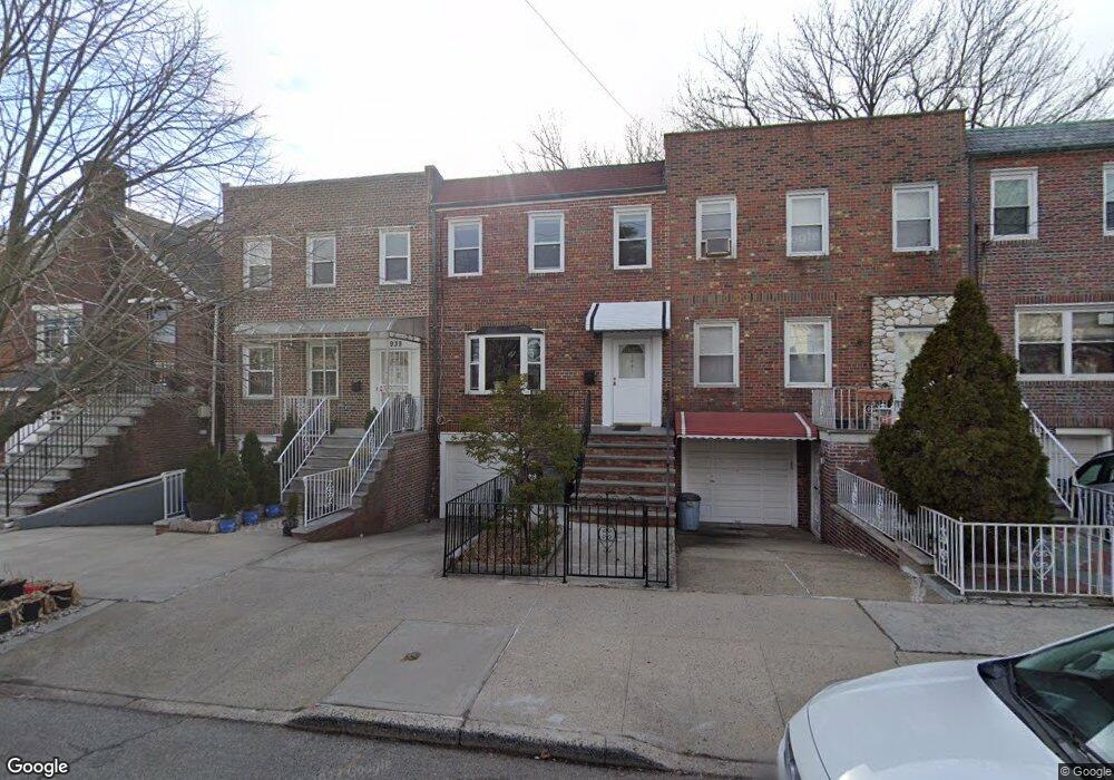
1939 Paulding Ave Bronx, NY 10462
Morris Park NeighborhoodEstimated Value: $763,879 - $862,000
Studio
--
Bath
1,870
Sq Ft
$445/Sq Ft
Est. Value
About This Home
This home is located at 1939 Paulding Ave, Bronx, NY 10462 and is currently estimated at $831,220, approximately $444 per square foot. 1939 Paulding Ave is a home located in Bronx County with nearby schools including P.S. 083 The Donald Hertz School, Icahn Charter School 2, and St. Clare of Assisi School.
Ownership History
Date
Name
Owned For
Owner Type
Purchase Details
Closed on
Oct 7, 2016
Sold by
9 Point Home Solutions Llc
Bought by
Caringal Fernando C and Caringal Lany T
Current Estimated Value
Home Financials for this Owner
Home Financials are based on the most recent Mortgage that was taken out on this home.
Original Mortgage
$408,000
Outstanding Balance
$320,658
Interest Rate
3.44%
Mortgage Type
Unknown
Estimated Equity
$510,562
Purchase Details
Closed on
Feb 26, 2016
Sold by
Debuono Darrell W and Debuono Margaret
Bought by
9 Point Home Solutions Llc
Create a Home Valuation Report for This Property
The Home Valuation Report is an in-depth analysis detailing your home's value as well as a comparison with similar homes in the area
Home Values in the Area
Average Home Value in this Area
Purchase History
We collect this data history from publicly available records. To have your information removed, we recommend requesting removal directly through your county’s website.
| Date | Buyer | Sale Price | Title Company |
|---|---|---|---|
| Caringal Fernando C | $520,000 | -- | |
| 9 Point Home Solutions Llc | $305,000 | -- |
Source: Public Records
Mortgage History
We collect this data history from publicly available records. To have your information removed, we recommend requesting removal directly through your county’s website.
| Date | Status | Borrower | Loan Amount |
|---|---|---|---|
| Open | Caringal Fernando C | $408,000 |
Source: Public Records
Tax History
| Year | Tax Paid | Tax Assessment Tax Assessment Total Assessment is a certain percentage of the fair market value that is determined by local assessors to be the total taxable value of land and additions on the property. | Land | Improvement |
|---|---|---|---|---|
| 2026 | $6,383 | $33,686 | $5,853 | $27,833 |
| 2025 | $6,022 | $31,780 | $5,782 | $25,998 |
| 2024 | $6,022 | $29,981 | $6,503 | $23,478 |
| 2023 | $6,089 | $29,981 | $6,061 | $23,920 |
| 2022 | $5,940 | $36,480 | $7,860 | $28,620 |
| 2021 | $5,908 | $32,280 | $7,860 | $24,420 |
| 2020 | $5,606 | $31,320 | $7,860 | $23,460 |
| 2019 | $5,226 | $31,020 | $7,860 | $23,160 |
| 2017 | $4,755 | $24,796 | $7,061 | $17,735 |
| 2016 | $4,367 | $23,393 | $7,077 | $16,316 |
| 2015 | $2,756 | $22,069 | $7,745 | $14,324 |
| 2014 | $2,756 | $20,820 | $8,760 | $12,060 |
Source: Public Records
Map
Nearby Homes
- 1945 Paulding Ave
- 986 Neill Ave
- 1954 Hone Ave
- 1925 Radcliff Ave
- 2004 Bogart Ave
- 1957 Bogart Ave
- 2037 Radcliff Ave
- 1831 Paulding Ave
- 2042 Bogart Ave
- 1942 Haight Ave
- 1950 Haight Ave
- 1100 Neill Ave
- 928 Rhinelander Ave
- 2021 Haight Ave
- 2028 Haight Ave
- 1116 Rhinelander Ave
- 1844 Tomlinson Ave
- 1863 Williamsbridge Rd
- 1730 Colden Ave
- 2080 Matthews Ave
- 1941 Paulding Ave
- 1937 Paulding Ave
- 1937 Paulding Ave Unit 1
- 1943 Paulding Ave
- 1935 Paulding Ave
- 1930 Colden Ave
- 1947 Paulding Ave
- 1940 Colden Ave
- 1938 Colden Ave
- 1942 Colden Ave
- 1949 Paulding Ave
- 1936 Colden Ave
- 1944 Colden Ave
- 1925 Paulding Ave
- 1925 Paulding Ave
- 1951 Paulding Ave
- 1922 Colden Ave
- 1948 Colden Ave
- 1923 Paulding Ave
- 1953 Paulding Ave
Your Personal Tour Guide
Ask me questions while you tour the home.