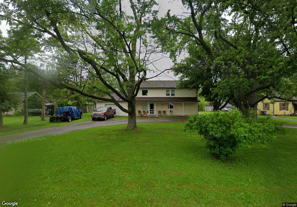
194 E 500 N Anderson, IN 46012
Estimated Value: $238,000 - $338,000
3
Beds
2
Baths
1,920
Sq Ft
$142/Sq Ft
Est. Value
About This Home
This home is located at 194 E 500 N, Anderson, IN 46012 and is currently estimated at $272,439, approximately $141 per square foot. 194 E 500 N is a home located in Madison County with nearby schools including Eastside Elementary School, Highland Middle School, and Anderson High School.
Ownership History
Date
Name
Owned For
Owner Type
Purchase Details
Closed on
Jun 19, 2006
Sold by
Grothaus Brian S and Grothaus Rachel J
Bought by
Russell Dale
Current Estimated Value
Home Financials for this Owner
Home Financials are based on the most recent Mortgage that was taken out on this home.
Original Mortgage
$106,052
Outstanding Balance
$62,203
Interest Rate
6.72%
Mortgage Type
FHA
Estimated Equity
$210,236
Purchase Details
Closed on
Mar 4, 2005
Sold by
Premium Homes Llc
Bought by
Grothaus Brian S and Grothaus Rachel J
Home Financials for this Owner
Home Financials are based on the most recent Mortgage that was taken out on this home.
Original Mortgage
$89,500
Interest Rate
5.7%
Mortgage Type
New Conventional
Create a Home Valuation Report for This Property
The Home Valuation Report is an in-depth analysis detailing your home's value as well as a comparison with similar homes in the area
Home Values in the Area
Average Home Value in this Area
Purchase History
| Date | Buyer | Sale Price | Title Company |
|---|---|---|---|
| Russell Dale | -- | -- | |
| Grothaus Brian S | -- | -- |
Source: Public Records
Mortgage History
| Date | Status | Borrower | Loan Amount |
|---|---|---|---|
| Open | Russell Dale | $106,052 | |
| Previous Owner | Grothaus Brian S | $89,500 |
Source: Public Records
Tax History
| Year | Tax Paid | Tax Assessment Tax Assessment Total Assessment is a certain percentage of the fair market value that is determined by local assessors to be the total taxable value of land and additions on the property. | Land | Improvement |
|---|---|---|---|---|
| 2025 | $1,605 | $163,000 | $28,200 | $134,800 |
| 2024 | $1,605 | $147,500 | $28,200 | $119,300 |
| 2023 | $1,532 | $135,000 | $26,800 | $108,200 |
| 2022 | $1,419 | $131,700 | $25,500 | $106,200 |
| 2021 | $1,308 | $121,600 | $25,300 | $96,300 |
| 2020 | $1,115 | $115,900 | $23,600 | $92,300 |
| 2019 | $1,165 | $116,600 | $23,600 | $93,000 |
| 2018 | $1,122 | $109,900 | $23,600 | $86,300 |
| 2017 | $820 | $103,100 | $23,000 | $80,100 |
| 2016 | $813 | $99,900 | $22,500 | $77,400 |
| 2014 | $610 | $92,100 | $21,200 | $70,900 |
| 2013 | $610 | $95,700 | $21,200 | $74,500 |
Source: Public Records
Map
Nearby Homes
- 68 E 500 N
- 5422 N State Road 9
- 111 Darin Ct
- 121 Darin Ct
- 114 Darin Ct
- 432 W 500 N
- 4403 Alexandria Pike
- 202 Cottonwood Dr
- 228 E 600 N
- 186 W 600 N
- 424 W 600 N
- 190 W 600 N
- 3533 Alexandria Pike
- 6291 N 100 W
- 4541 N 200 E
- 3107 Waterfront Cir
- 318 E 300 N
- 0 E Hartman Rd
- 2976 N Scatterfield Rd
- 616 Vermillion Ct
- 148 E 500 N
- 172 E 500 N
- 210 E 500 N
- 240 E 500 N
- 130 E 500 N
- 130 E 500 N
- 266 E 500 N
- 5103 Alexandria Pike
- 5129 Alexandria Pike
- 5091 Alexandria Pike
- 193 E 500 N
- 171 E 500 N
- 5149 Alexandria Pike
- 211 E 500 N
- 5081 Alexandria Pike
- 227 E 500 N
- 145 E 500 N
- 86 E 500 N
- 5195 Alexandria Pike
- 5195 Alexandria Pike Unit Anderson
Your Personal Tour Guide
Ask me questions while you tour the home.