


1943 182nd St Lansing, IL 60438
Estimated payment $2,363/month
Highlights
- In Ground Pool
- L-Shaped Dining Room
- Patio
- Wood Flooring
- 2 Car Attached Garage
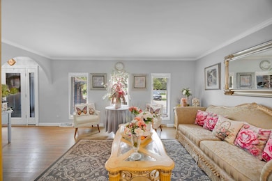
- Living Room
About This Home
!! OPEN ..!!! SATURDAY THE 28TH, FROM 2:00 TILL 4:00..... This lovely 3 bedroom and 2 bath tri-level home also includes an in-ground pool with a very nice yard space and covered patio for BBQ's. Separate dining room, eat in kitchen with appliances, granite counter tops, and a pantry closet. The brand new patio doors open to the back yard. The three bedrooms and remodeled bath are upstairs. The family room with fireplace is in the lower level along with the second bath and utility room that leads in to the garage. All hardwood floors. Newer roof.
Home Details
Home Type
- Single Family
Est. Annual Taxes
- $11,128
Year Built
- Built in 1986
Lot Details
- Lot Dimensions are 67 x 127
- Fenced
Parking
- 2 Car Attached Garage
- Parking Available
- Garage Door Opener
- Driveway
Home Design
- Split Level Home
- Tri-Level Property
- Brick Exterior Construction
- Frame Construction
- Asphalt Roof
- Concrete Perimeter Foundation
Interior Spaces
- 1,225 Sq Ft Home
- Ceiling Fan
- Family Room with Fireplace
- Living Room
- L-Shaped Dining Room
- Wood Flooring
- Unfinished Attic
- Laundry Room
Kitchen
- Range
- Microwave
Bedrooms and Bathrooms
- 3 Bedrooms
- 3 Potential Bedrooms
- 2 Full Bathrooms
Finished Basement
- Partial Basement
- Finished Basement Bathroom
Outdoor Features
- In Ground Pool
- Patio
Utilities
- Forced Air Heating and Cooling System
- Heating System Uses Natural Gas
- Lake Michigan Water
Community Details
- Dejong Gardens Subdivision
Map
Home Values in the Area
Average Home Value in this Area
Tax History
| Year | Tax Paid | Tax Assessment Tax Assessment Total Assessment is a certain percentage of the fair market value that is determined by local assessors to be the total taxable value of land and additions on the property. | Land | Improvement |
|---|---|---|---|---|
| 2025 | $11,128 | $23,001 | $4,890 | $18,111 |
| 2024 | $11,128 | $23,001 | $4,890 | $18,111 |
| 2023 | $10,080 | $23,001 | $4,890 | $18,111 |
| 2022 | $10,080 | $15,511 | $4,223 | $11,288 |
| 2021 | $9,805 | $15,510 | $4,222 | $11,288 |
| 2020 | $9,100 | $15,510 | $4,222 | $11,288 |
| 2019 | $8,092 | $14,213 | $3,556 | $10,657 |
| 2018 | $7,942 | $14,213 | $3,556 | $10,657 |
| 2017 | $8,019 | $14,213 | $3,556 | $10,657 |
| 2016 | $7,164 | $13,101 | $3,333 | $9,768 |
| 2015 | $6,656 | $13,101 | $3,333 | $9,768 |
| 2014 | $6,564 | $13,101 | $3,333 | $9,768 |
| 2013 | $4,334 | $14,133 | $3,333 | $10,800 |
Property History
| Date | Event | Price | List to Sale | Price per Sq Ft |
|---|---|---|---|---|
| 01/23/2026 01/23/26 | Price Changed | $269,000 | -3.6% | $220 / Sq Ft |
| 11/17/2025 11/17/25 | Price Changed | $279,000 | -3.5% | $228 / Sq Ft |
| 09/03/2025 09/03/25 | For Sale | $289,000 | -- | $236 / Sq Ft |
Purchase History
| Date | Type | Sale Price | Title Company |
|---|---|---|---|
| Interfamily Deed Transfer | -- | None Available | |
| Interfamily Deed Transfer | -- | None Available | |
| Interfamily Deed Transfer | -- | -- | |
| Warranty Deed | $154,000 | -- |
Mortgage History
| Date | Status | Loan Amount | Loan Type |
|---|---|---|---|
| Open | $95,000 | Purchase Money Mortgage |
Source: Midwest Real Estate Data (MRED)
MLS Number: 12459273
APN: 29-36-311-015-0000
Disclaimer: Certain information contained herein is derived from information provided by parties other than Homes.com. All information provided is deemed reliable, but is not guaranteed to be accurate and should be independently verified.
![]() Based on information submitted to the MLS GRID. All data is obtained from various sources and may not have been verified by broker or MLS GRID. Supplied Open House Information is subject to change without notice. All information should be independently reviewed and verified for accuracy. Properties may or may not be listed by the office/agent presenting the information. Some IDX listings have been excluded from this website.
Based on information submitted to the MLS GRID. All data is obtained from various sources and may not have been verified by broker or MLS GRID. Supplied Open House Information is subject to change without notice. All information should be independently reviewed and verified for accuracy. Properties may or may not be listed by the office/agent presenting the information. Some IDX listings have been excluded from this website.
Based on information submitted to the MLS GRID
- 18118 Whitman Ln
- 18311 Holland Rd
- 18319 Holland Rd
- 17750 Clyde Ave
- 1999 Indiana Ave
- 18309 Bock Rd
- 1844 180th Place
- 2201 Thornton Lansing Rd
- 18439 Locust St
- 18539 Country Ln
- 18331 Hickory St
- 18555 Olde Farm Rd
- 17934 Locust St
- 2308 185th St
- 18036 Crystal Ln
- 17909 Rose St
- 18317 Harper St
- 17871 Locust St
- 1555 Thornton Lansing Rd
- 2345 185th Ct Unit 27
- 17754 Rosewood Dr Unit 1N
- 18446 Torrence Ave Unit 2E
- 17701 Park Blvd Unit 304
- 3002-3044 Bernice Ave
- 3060 Bernice Ave Unit 2N
- 18335 Sherman St Unit 2
- 2511 Terrace Ave Unit 1E
- 17053 Lorenz Ave
- 19719 Terrace Ave Unit 3
- 450 E Mulberry Ct
- 3622 178th St
- 827 E 194th St Unit 827
- 17301 Wausau Ct
- 20037 Orchard Ave
- 20126 Ash Ln
- 20124 Oak Ln
- 7500 Hohman Ave
- 7611 Kinsley Place
- 7610 Manor Ave
- 52 N Glenwood Ave

Ask me questions while you tour the home.