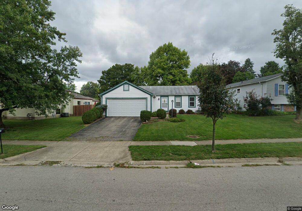
1946 Plains Blvd Powell, OH 43065
Western Hills NeighborhoodEstimated Value: $319,000 - $376,000
About This Home
This home is located at 1946 Plains Blvd, Powell, OH 43065 and is currently estimated at $342,915, approximately $297 per square foot. 1946 Plains Blvd is a home located in Franklin County with nearby schools including Liberty Elementary School, McCord Middle School, and Worthington Kilbourne High School.
Ownership History
We collect this data history from publicly available records. To have your information removed, we recommend requesting removal directly through your county’s website.
Purchase Details
Home Financials for this Owner
Home Financials are based on the most recent Mortgage that was taken out on this home.Purchase Details
Purchase Details
Purchase Details
Home Values in the Area
Average Home Value in this Area
Purchase History
We collect this data history from publicly available records. To have your information removed, we recommend requesting removal directly through your county’s website.
| Date | Buyer | Sale Price | Title Company |
|---|---|---|---|
| -- | Profession | ||
| $105,000 | -- | ||
| $70,000 | -- | ||
| -- | -- |
Mortgage History
We collect this data history from publicly available records. To have your information removed, we recommend requesting removal directly through your county’s website.
| Date | Status | Borrower | Loan Amount |
|---|---|---|---|
| Open | $170,000 | ||
| Closed | $147,250 | ||
| Closed | $120,800 |
Tax History
We collect this data history from publicly available records. To have your information removed, we recommend requesting removal directly through your county’s website.
| Year | Tax Paid | Tax Assessment Tax Assessment Total Assessment is a certain percentage of the fair market value that is determined by local assessors to be the total taxable value of land and additions on the property. | Land | Improvement |
|---|---|---|---|---|
| 2025 | $5,714 | $93,070 | $33,250 | $59,820 |
| 2024 | $5,714 | $93,070 | $33,250 | $59,820 |
| 2023 | $5,464 | $93,070 | $33,250 | $59,820 |
| 2022 | $4,289 | $57,970 | $18,100 | $39,870 |
| 2021 | $3,957 | $57,970 | $18,100 | $39,870 |
| 2020 | $3,812 | $57,970 | $18,100 | $39,870 |
| 2019 | $3,553 | $48,760 | $15,090 | $33,670 |
| 2018 | $3,426 | $48,760 | $15,090 | $33,670 |
| 2017 | $3,184 | $48,760 | $15,090 | $33,670 |
| 2016 | $3,410 | $48,030 | $13,410 | $34,620 |
| 2015 | $3,411 | $48,030 | $13,410 | $34,620 |
| 2014 | $3,409 | $48,030 | $13,410 | $34,620 |
| 2013 | $1,696 | $48,020 | $13,405 | $34,615 |
Map
- 8224 Laramie Place Unit 3
- 8328 Lariat Ct
- 2061 Stowbridge Rd
- 2077 Scottingham Dr
- 8503 Nimitz Dr
- 7950 Trellage Ct Unit 7
- 7935 Verandah Ct Unit 50
- 7929 Verandah Ct Unit 51
- 1955 Barnard Dr
- 1539 Clubview Blvd S
- 2021 Torreys Place
- 7735 Schoolway Ct
- 2087-2089 Summit Row Blvd
- 1501 Candlewood Dr
- 2074 Hard Rd
- 2230 Summit View Rd
- 7836 Saddle Run
- 2400 Willis Rd
- 8766 Gallo Dr
- 8715 Ripton Dr
- 1940 Plains Blvd
- 1928 Plains Blvd
- 8280 Lariat Ct
- 8282 Lariat Ct
- 8270 Lariat Ct
- 8287 Highridge Dr
- 8284 Lariat Ct
- 8295 High Ridge Dr
- 8286 Lariat Ct
- 1930 Lost Valley Rd
- 8290 Lariat Ct
- 1927 Lost Valley Rd
- 8294 Lariat Ct
- 8298 Lariat Ct
- 1957 Plains Blvd
- 1912 Plains Blvd
- 8302 Lariat Ct
- 1926 Lost Valley Rd
- 1980 Plains Blvd
- 1909 Plains Blvd
Ask me questions while you tour the home.