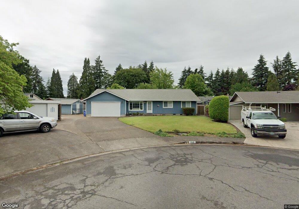
1948 Minda Dr Eugene, OR 97401
Cal Young NeighborhoodEstimated Value: $528,054 - $578,000
3
Beds
2
Baths
1,818
Sq Ft
$305/Sq Ft
Est. Value
About This Home
This home is located at 1948 Minda Dr, Eugene, OR 97401 and is currently estimated at $554,764, approximately $305 per square foot. 1948 Minda Dr is a home located in Lane County with nearby schools including Willagillespie Elementary School, Monroe Middle School, and Sheldon High School.
Ownership History
Date
Name
Owned For
Owner Type
Purchase Details
Closed on
Mar 15, 2022
Sold by
Summers Leroy and Summers Leslie
Bought by
Summers Family Trust and Summers
Current Estimated Value
Purchase Details
Closed on
Mar 8, 1999
Sold by
Kersey Kelly C and Kersey Jamie L
Bought by
Summers Leroy and Summers Leslie
Home Financials for this Owner
Home Financials are based on the most recent Mortgage that was taken out on this home.
Original Mortgage
$119,200
Interest Rate
6.33%
Create a Home Valuation Report for This Property
The Home Valuation Report is an in-depth analysis detailing your home's value as well as a comparison with similar homes in the area
Home Values in the Area
Average Home Value in this Area
Purchase History
| Date | Buyer | Sale Price | Title Company |
|---|---|---|---|
| Summers Family Trust | -- | None Listed On Document | |
| Summers Leroy | $149,000 | Western Pioneer Title Co |
Source: Public Records
Mortgage History
| Date | Status | Borrower | Loan Amount |
|---|---|---|---|
| Previous Owner | Summers Leroy | $119,200 |
Source: Public Records
Tax History
| Year | Tax Paid | Tax Assessment Tax Assessment Total Assessment is a certain percentage of the fair market value that is determined by local assessors to be the total taxable value of land and additions on the property. | Land | Improvement |
|---|---|---|---|---|
| 2025 | $5,641 | $289,501 | -- | -- |
| 2024 | $5,570 | $281,069 | -- | -- |
| 2023 | $5,570 | $272,883 | -- | -- |
| 2022 | $5,218 | $264,935 | $0 | $0 |
| 2021 | $4,901 | $257,219 | $0 | $0 |
| 2020 | $4,919 | $249,728 | $0 | $0 |
| 2019 | $4,751 | $242,455 | $0 | $0 |
| 2018 | $4,472 | $228,538 | $0 | $0 |
| 2017 | $4,267 | $228,538 | $0 | $0 |
| 2016 | $4,087 | $221,882 | $0 | $0 |
| 2015 | $3,905 | $215,419 | $0 | $0 |
| 2014 | $3,769 | $209,145 | $0 | $0 |
Source: Public Records
Map
Nearby Homes
- 1810 Minda Dr
- 1901 Minda Dr
- 1943 Monterey Ln
- 1625 Monterey Ln
- 1521 Gilham Rd
- 0 Cal Young Rd Unit Lot 4
- 1500 Norkenzie Rd Unit 12
- 2291 Norkenzie Rd
- 1332 Jeppesen Ave
- 1328 Spyglass Dr
- 2495 Jeppesen Acres Rd
- 0 Piper Ln Unit Lot 1
- 0 Piper Ln Unit Lot 3
- 0 Piper Ln Unit Lot 2
- 0 Piper Ln Unit Lot 5
- 2132 Willona Dr
- 2134 Willona Dr
- 1697 Elanco Ave
- 2207 Willona Dr
- 2280 Tabor St
Your Personal Tour Guide
Ask me questions while you tour the home.