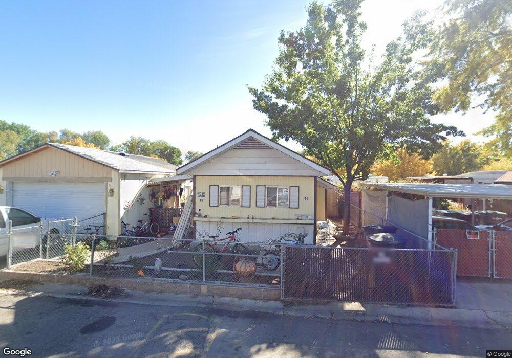
1952 W 450 N Provo, UT 84601
Lakeview Neighborhood
2
Beds
1
Bath
1,000
Sq Ft
4,356
Sq Ft Lot
About This Home
This home is located at 1952 W 450 N, Provo, UT 84601. 1952 W 450 N is a home located in Utah County with nearby schools including Dixon Middle School, Provo High School, and Freedom Preparatory Academy.
Ownership History
Date
Name
Owned For
Owner Type
Purchase Details
Closed on
Jun 3, 2013
Sold by
Rymer Cari B
Bought by
Valdez Eduardo and Rodriguez Celia
Purchase Details
Closed on
May 26, 2011
Sold by
Cochard William A and Cochard Ann C
Bought by
Rymer Cari B
Purchase Details
Closed on
Mar 17, 1997
Sold by
Claybaugh Donn R and Claybaugh Jeanne C
Bought by
Cochard William A and Cochard Ann C
Purchase Details
Closed on
Dec 30, 1996
Sold by
Miller Kay
Bought by
Claybaugh Donn R and Claybaugh Jeanne C
Create a Home Valuation Report for This Property
The Home Valuation Report is an in-depth analysis detailing your home's value as well as a comparison with similar homes in the area
Home Values in the Area
Average Home Value in this Area
Purchase History
| Date | Buyer | Sale Price | Title Company |
|---|---|---|---|
| Valdez Eduardo | -- | Titan Title Insurance Agency | |
| Rymer Cari B | -- | Executive Title Orem | |
| Cochard William A | -- | -- | |
| Claybaugh Donn R | -- | -- |
Source: Public Records
Tax History
| Year | Tax Paid | Tax Assessment Tax Assessment Total Assessment is a certain percentage of the fair market value that is determined by local assessors to be the total taxable value of land and additions on the property. | Land | Improvement |
|---|---|---|---|---|
| 2025 | $520 | $80,740 | -- | -- |
| 2024 | $520 | $51,205 | $0 | $0 |
| 2023 | $528 | $51,205 | $0 | $0 |
| 2022 | $555 | $54,285 | $0 | $0 |
| 2021 | $407 | $58,100 | $49,700 | $8,400 |
| 2020 | $335 | $53,600 | $45,200 | $8,400 |
| 2019 | $322 | $53,600 | $45,200 | $8,400 |
| 2018 | $318 | $53,600 | $45,200 | $8,400 |
| 2017 | $287 | $26,620 | $0 | $0 |
| 2016 | $264 | $22,796 | $0 | $0 |
| 2015 | $261 | $22,796 | $0 | $0 |
| 2014 | $250 | $22,796 | $0 | $0 |
Source: Public Records
Map
Nearby Homes
- 255 N 1600 W Unit 148
- 255 N 1600 W Unit 52
- 255 N 1600 W Unit 60
- 255 N 1600 W Unit 108
- 255 N 1600 W Unit 94
- 255 N 1600 W Unit 73
- 407 N 2150 W
- 579 N Geneva Rd
- 213 N Geneva Rd
- 1631 W 50 N
- 1903 W 890 N
- 2507 W 520 N
- 483 N 2430 W
- 927 Independence Ave
- 1524 Merlin Dr
- 1375 W 500 N Unit 95
- 925 N 1760 W
- 962 Independence Ave
- 146 S 1860 W
- 112 S 2120 W
- 1932 W 450 N
- 1972 W 450 N Unit 83
- 1967 W 450 N
- 1937 W 450 N
- 1927 W 450 N
- 1982 W 450 N Unit 82
- 1915 W 350 N
- 1917 W 450 N Unit 66
- 1935 W 350 St N Unit 90
- 1944 W 500 N
- 1954 W 550 St N
- 1934 W 500 N Unit 57
- 1934 W 500 N
- 1907 W 450 N
- 1974 W 550 St N
- 1897 W 450 N
- 1997 W 450 N
- 2002 W 450 N
- 1984 W 550 St N
- 1900 W 350 N
Your Personal Tour Guide
Ask me questions while you tour the home.