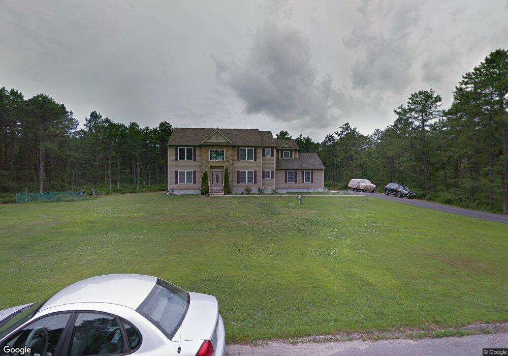
1961 Baltimore Ave Whiting, NJ 08759
Estimated Value: $740,000 - $814,000
5
Beds
3
Baths
2,639
Sq Ft
$295/Sq Ft
Est. Value
About This Home
This home is located at 1961 Baltimore Ave, Whiting, NJ 08759 and is currently estimated at $779,536, approximately $295 per square foot. 1961 Baltimore Ave is a home located in Ocean County with nearby schools including Manchester Township High School.
Ownership History
Date
Name
Owned For
Owner Type
Purchase Details
Closed on
Jun 29, 2007
Sold by
Ridgeback Builders Llc
Bought by
Rollins Paul and Rollins Cirila
Current Estimated Value
Home Financials for this Owner
Home Financials are based on the most recent Mortgage that was taken out on this home.
Original Mortgage
$417,000
Outstanding Balance
$257,078
Interest Rate
6.24%
Mortgage Type
Purchase Money Mortgage
Estimated Equity
$522,458
Purchase Details
Closed on
Nov 3, 2004
Sold by
Dalton Reginald
Bought by
Ridgeback Builders Llc
Purchase Details
Closed on
Dec 15, 1998
Sold by
Kitson Ruth E
Bought by
Dalton Reginald
Create a Home Valuation Report for This Property
The Home Valuation Report is an in-depth analysis detailing your home's value as well as a comparison with similar homes in the area
Home Values in the Area
Average Home Value in this Area
Purchase History
| Date | Buyer | Sale Price | Title Company |
|---|---|---|---|
| Rollins Paul | $530,800 | Pegasus Title Agency Llc | |
| Ridgeback Builders Llc | $148,000 | -- | |
| Dalton Reginald | $21,000 | -- |
Source: Public Records
Mortgage History
| Date | Status | Borrower | Loan Amount |
|---|---|---|---|
| Open | Rollins Paul | $417,000 |
Source: Public Records
Tax History
| Year | Tax Paid | Tax Assessment Tax Assessment Total Assessment is a certain percentage of the fair market value that is determined by local assessors to be the total taxable value of land and additions on the property. | Land | Improvement |
|---|---|---|---|---|
| 2025 | $10,331 | $710,000 | $195,000 | $515,000 |
| 2024 | $9,835 | $422,100 | $85,000 | $337,100 |
| 2023 | $9,350 | $422,100 | $85,000 | $337,100 |
| 2022 | $9,350 | $422,100 | $85,000 | $337,100 |
| 2021 | $9,147 | $422,100 | $85,000 | $337,100 |
| 2020 | $8,906 | $422,100 | $85,000 | $337,100 |
| 2019 | $9,388 | $366,000 | $85,000 | $281,000 |
| 2018 | $9,351 | $366,000 | $85,000 | $281,000 |
| 2017 | $9,388 | $366,000 | $85,000 | $281,000 |
| 2016 | $9,274 | $366,000 | $85,000 | $281,000 |
| 2015 | $9,102 | $366,000 | $85,000 | $281,000 |
| 2014 | $8,916 | $366,000 | $85,000 | $281,000 |
Source: Public Records
Map
Nearby Homes
- 151 Adams St
- 1901 Baltimore Ave
- 1130 Monroe Ave
- 19 Attleboro Ln Unit 73
- 19 Attleboro Ln
- 6 Orchard Dr Unit 73
- 53 Central Ave
- 53 Central Ave Unit 72
- 3 Apple Ln Unit 72
- 51 Central Ave Unit 72
- 7 Eaton Ln Unit 73
- 8 Hummingbird Ln
- 1820 Perth Amboy Ave
- 55 Chelsea Dr Unit 70
- 10 Hartford Rd
- 69 Chelsea Dr
- 1580 Cabot Ave
- 551 Monroe Ave
- 31 Chelsea Dr
- 1560 Cabot Ave
- 1941 Baltimore Ave
- 1960 Delaware Ave
- 1940 Delaware Ave
- 1960 Baltimore Ave
- 1980 Baltimore Ave
- 1940 Baltimore Ave
- 1921 Baltimore Ave
- 1920 Delaware Ave
- 1920 Baltimore Ave
- 1941 Delaware Ave
- 1961 Philadelphia Ave
- 1941 Philadelphia Ave
- 1600 Hegstrom Ave
- 1921 Delaware Ave
- 1900 Delaware Ave
- 1350 Roosevelt City Rd
- 1900 Baltimore Ave
- 1801 Coolidge Ave
- 1901 Philadelphia Ave
- 1960 Philadelphia Ave
Your Personal Tour Guide
Ask me questions while you tour the home.