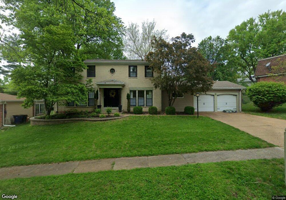
1961 Pepperrell Dr Saint Louis, MO 63146
Estimated Value: $427,390 - $518,000
4
Beds
3
Baths
2,514
Sq Ft
$194/Sq Ft
Est. Value
About This Home
This home is located at 1961 Pepperrell Dr, Saint Louis, MO 63146 and is currently estimated at $488,348, approximately $194 per square foot. 1961 Pepperrell Dr is a home located in St. Louis County with nearby schools including River Bend Elementary School, Parkway Central Middle School, and Parkway Central High School.
Ownership History
Date
Name
Owned For
Owner Type
Purchase Details
Closed on
Nov 8, 2001
Sold by
James Marcia J
Bought by
Ortmann Thomas A and Ortmann Amy C
Current Estimated Value
Home Financials for this Owner
Home Financials are based on the most recent Mortgage that was taken out on this home.
Original Mortgage
$158,800
Outstanding Balance
$60,117
Interest Rate
6.59%
Estimated Equity
$428,231
Create a Home Valuation Report for This Property
The Home Valuation Report is an in-depth analysis detailing your home's value as well as a comparison with similar homes in the area
Home Values in the Area
Average Home Value in this Area
Purchase History
| Date | Buyer | Sale Price | Title Company |
|---|---|---|---|
| Ortmann Thomas A | $198,500 | -- | |
| Ortmann Thomas A | $198,500 | -- |
Source: Public Records
Mortgage History
| Date | Status | Borrower | Loan Amount |
|---|---|---|---|
| Open | Ortmann Thomas A | $158,800 | |
| Closed | Ortmann Thomas A | $19,850 |
Source: Public Records
Tax History
| Year | Tax Paid | Tax Assessment Tax Assessment Total Assessment is a certain percentage of the fair market value that is determined by local assessors to be the total taxable value of land and additions on the property. | Land | Improvement |
|---|---|---|---|---|
| 2025 | $4,618 | $75,930 | $34,470 | $41,460 |
| 2024 | $4,618 | $69,770 | $22,990 | $46,780 |
| 2023 | $4,618 | $69,770 | $22,990 | $46,780 |
| 2022 | $3,804 | $54,470 | $19,150 | $35,320 |
| 2021 | $3,789 | $54,470 | $19,150 | $35,320 |
| 2020 | $3,729 | $51,490 | $17,180 | $34,310 |
| 2019 | $3,648 | $51,490 | $17,180 | $34,310 |
| 2018 | $3,879 | $50,790 | $17,180 | $33,610 |
| 2017 | $3,773 | $50,790 | $17,180 | $33,610 |
| 2016 | $3,360 | $42,940 | $14,330 | $28,610 |
| 2015 | $3,521 | $42,940 | $14,330 | $28,610 |
| 2014 | $3,109 | $40,660 | $8,680 | $31,980 |
Source: Public Records
Map
Nearby Homes
- 1944 Pepperrell Dr
- 1946 Burlewood Dr
- 12953 Mayerling Dr
- 13023 Walnutway Manor
- 13140 Greenbough Dr
- 13172 Greenbough Dr
- 2001 King Arthur Ct
- 1803 Seven Pines Dr
- 2250 Seven Pines Dr
- 12934 Ballantine Ct
- 2316 Seven Pines Dr Unit 1
- 13138 Royal Pines Dr Unit 2
- 1500 Heirloom Ct
- 1960 Marine Terrace Dr Unit K
- 1960 Marine Terrace Dr Unit H
- 1948 Marine Terrace Dr Unit A
- 2115 Riding Spur Dr
- 1936 Marine Terrace Dr Unit J
- 13112 Royal Pines Dr
- 2147 Riding Spur Dr
- 1955 Pepperrell Dr
- 1969 Pepperrell Dr
- 13164 Weatherfield Dr
- 1968 Beacongrove Dr
- 13156 Weatherfield Dr
- 1958 Pepperrell Dr
- 1949 Pepperrell Dr
- 1976 Beacongrove Dr
- 1962 Beacongrove Dr
- 1970 Pepperrell Dr
- 1950 Pepperrell Dr
- 1956 Beacongrove Dr
- 1943 Pepperrell Dr
- 13130 Weatherfield Dr
- 13146 Roundstone Ct
- 13155 Roundstone Ct
- 13165 Weatherfield Dr
- 13153 Weatherfield Dr
- 13124 Weatherfield Dr
- 1948 Beacongrove Dr
Your Personal Tour Guide
Ask me questions while you tour the home.