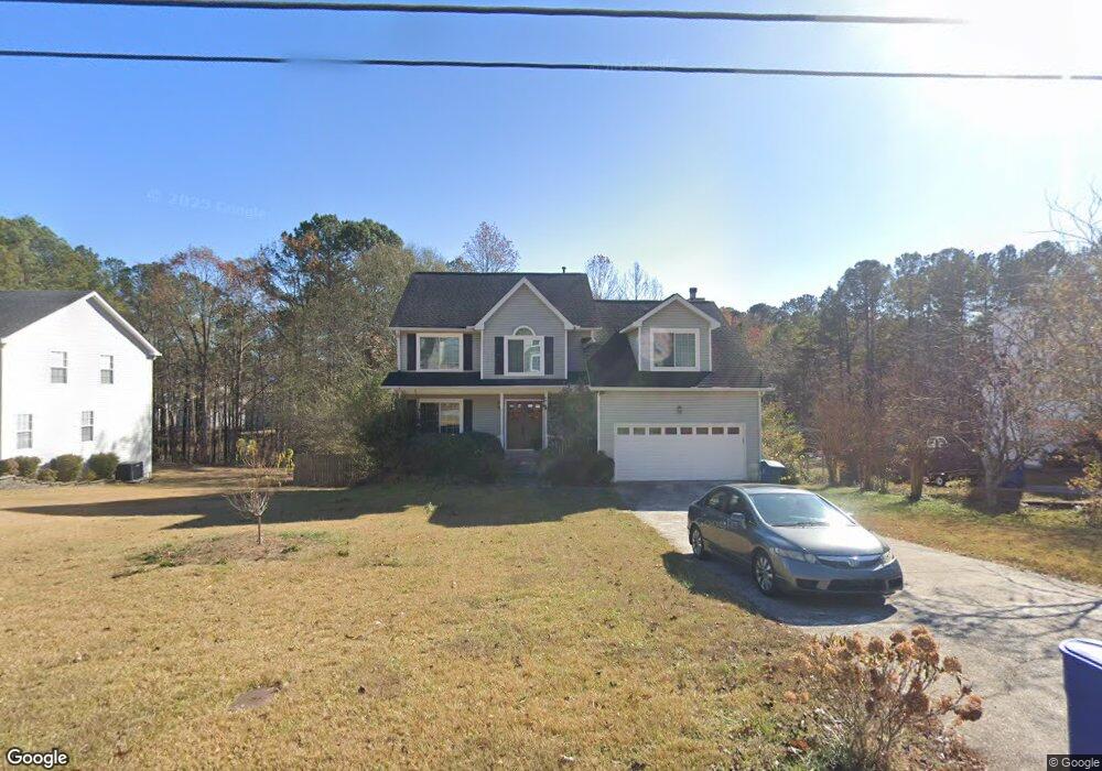
1965 Rocksram Dr Buford, GA 30519
Estimated Value: $385,000 - $424,000
3
Beds
3
Baths
2,246
Sq Ft
$178/Sq Ft
Est. Value
About This Home
This home is located at 1965 Rocksram Dr, Buford, GA 30519 and is currently estimated at $399,357, approximately $177 per square foot. 1965 Rocksram Dr is a home located in Gwinnett County with nearby schools including Woodward Mill Elementary School, Twin Rivers Middle School, and Mountain View High School.
Ownership History
Date
Name
Owned For
Owner Type
Purchase Details
Closed on
Aug 16, 2011
Sold by
Secretary Of Housing And U
Bought by
Landers Corey and Landers Sarah
Current Estimated Value
Home Financials for this Owner
Home Financials are based on the most recent Mortgage that was taken out on this home.
Original Mortgage
$93,930
Outstanding Balance
$64,449
Interest Rate
4.53%
Mortgage Type
FHA
Estimated Equity
$334,908
Purchase Details
Closed on
Oct 5, 2010
Sold by
Suntrust Mtg Inc
Bought by
Hud-Housing Of Urban Dev
Purchase Details
Closed on
Nov 13, 2003
Sold by
Pearson Mark R
Bought by
Keith Scott H
Home Financials for this Owner
Home Financials are based on the most recent Mortgage that was taken out on this home.
Original Mortgage
$155,150
Interest Rate
6.05%
Mortgage Type
VA
Purchase Details
Closed on
Mar 24, 1993
Sold by
Countryside Inv Co
Bought by
Pearson Mark R Robin
Home Financials for this Owner
Home Financials are based on the most recent Mortgage that was taken out on this home.
Original Mortgage
$91,000
Interest Rate
7.5%
Mortgage Type
VA
Create a Home Valuation Report for This Property
The Home Valuation Report is an in-depth analysis detailing your home's value as well as a comparison with similar homes in the area
Home Values in the Area
Average Home Value in this Area
Purchase History
We collect this data history from publicly available records. To have your information removed, we recommend requesting removal directly through your county’s website.
| Date | Buyer | Sale Price | Title Company |
|---|---|---|---|
| Landers Corey | $92,000 | -- | |
| Hud-Housing Of Urban Dev | -- | -- | |
| Suntrust Mtg Inc | $149,448 | -- | |
| Keith Scott H | $156,500 | -- | |
| Pearson Mark R Robin | $105,400 | -- |
Source: Public Records
Mortgage History
We collect this data history from publicly available records. To have your information removed, we recommend requesting removal directly through your county’s website.
| Date | Status | Borrower | Loan Amount |
|---|---|---|---|
| Open | Landers Corey | $93,930 | |
| Previous Owner | Keith Scott H | $155,150 | |
| Previous Owner | Pearson Mark R Robin | $91,000 |
Source: Public Records
Tax History
| Year | Tax Paid | Tax Assessment Tax Assessment Total Assessment is a certain percentage of the fair market value that is determined by local assessors to be the total taxable value of land and additions on the property. | Land | Improvement |
|---|---|---|---|---|
| 2025 | $4,587 | $174,320 | $23,920 | $150,400 |
| 2024 | $4,486 | $162,680 | $28,000 | $134,680 |
| 2023 | $4,486 | $162,480 | $28,000 | $134,480 |
| 2022 | $3,428 | $113,080 | $16,000 | $97,080 |
| 2021 | $3,204 | $100,360 | $16,000 | $84,360 |
| 2020 | $3,226 | $100,360 | $16,000 | $84,360 |
| 2019 | $3,024 | $94,760 | $16,000 | $78,760 |
| 2018 | $2,923 | $90,000 | $16,000 | $74,000 |
| 2016 | $2,554 | $72,000 | $12,400 | $59,600 |
| 2015 | $2,313 | $61,280 | $8,400 | $52,880 |
| 2014 | -- | $61,280 | $8,400 | $52,880 |
Source: Public Records
Map
Nearby Homes
- 1880 Rocksram Dr Unit 1
- 2375 Rock Springs Rd
- 2220 Sunny Hill Rd
- 2199 Sunny Hill Rd
- 2159 Sunny Hill Rd
- 2469 Rock Springs Rd Unit LOT 2
- 2469 Rock Springs Rd
- 2473 Rock Springs Rd
- 2473 Rock Springs Rd Unit LOT 4
- 2004 Brittlebank Ln
- 2055 Wynfield Point Dr
- 1521 Jami Hollow Way
- 2510 Sunny Hill Rd
- 1845 Hanover West Dr
- 1876 Hanover West Dr
- 1975 Wynfield Point Dr
- 1912 Arbor Springs Way
- 2345 Valley Mill Dr
- 2012 Arbor Springs Way
- 2053 Arbor Springs Way
- 1955 Rocksram Dr
- 1975 Rocksram Dr
- 1945 Rocksram Dr Unit 1
- 1985 Rocksram Dr
- 1960 Rocksram Dr
- 1970 Rocksram Dr
- 1950 Rocksram Dr Unit 2
- 1980 Rocksram Dr
- 1935 Rocksram Dr
- 1995 Rocksram Dr
- 1940 Rocksram Dr Unit 1
- 1990 Rocksram Dr Unit GA1224
- 1990 Rocksram Dr
- 1990 Rocksram Dr Unit GA12243
- 1930 Rocksram Dr Unit 1
- 1925 Rocksram Dr
- 2005 Rocksram Dr Unit 2
- 2005 Rocksram Dr
- 2005 Rocksram Dr Unit 2005
- 1920 Rocksram Dr Unit 1
Your Personal Tour Guide
Ask me questions while you tour the home.