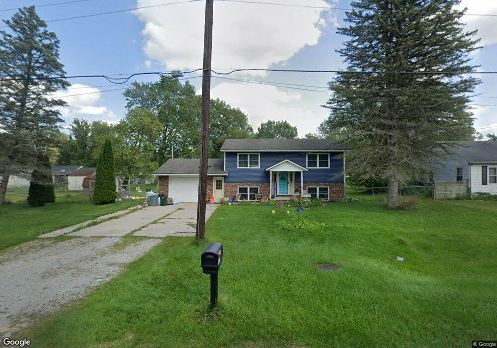
1978 Hickory Rd Kimball, MI 48074
Estimated Value: $207,020 - $264,000
3
Beds
2
Baths
1,536
Sq Ft
$147/Sq Ft
Est. Value
About This Home
This home is located at 1978 Hickory Rd, Kimball, MI 48074 and is currently estimated at $226,505, approximately $147 per square foot. 1978 Hickory Rd is a home located in St. Clair County with nearby schools including Kimball Elementary School, Central Middle School, and Port Huron High School.
Ownership History
Date
Name
Owned For
Owner Type
Purchase Details
Closed on
Aug 10, 2018
Sold by
Kelp Thomas C and Kelp Laura G
Bought by
Kelp Thomas C and Kelp Thomas C
Current Estimated Value
Purchase Details
Closed on
Aug 7, 2018
Sold by
Kelp Thomas C and Kelp Laura G
Bought by
Kelp Thomas C and Kelp Thomas C
Purchase Details
Closed on
Jul 30, 2009
Sold by
Carter Ryan S and Carter Shannon K
Bought by
Lpp Mortgage Ltd
Create a Home Valuation Report for This Property
The Home Valuation Report is an in-depth analysis detailing your home's value as well as a comparison with similar homes in the area
Home Values in the Area
Average Home Value in this Area
Purchase History
| Date | Buyer | Sale Price | Title Company |
|---|---|---|---|
| Kelp Thomas C | -- | None Listed On Document | |
| Kelp Thomas C | -- | None Listed On Document | |
| Kelp Thomas C | -- | None Available | |
| Lpp Mortgage Ltd | $80,000 | None Available |
Source: Public Records
Tax History
| Year | Tax Paid | Tax Assessment Tax Assessment Total Assessment is a certain percentage of the fair market value that is determined by local assessors to be the total taxable value of land and additions on the property. | Land | Improvement |
|---|---|---|---|---|
| 2025 | $865 | $69,800 | $0 | $0 |
| 2024 | $840 | $69,600 | $0 | $0 |
| 2023 | $769 | $66,900 | $0 | $0 |
| 2022 | $1,361 | $59,500 | $0 | $0 |
| 2020 | $1,243 | $52,000 | $0 | $52,000 |
| 2019 | $1,207 | $47,300 | $0 | $0 |
| 2018 | $1,260 | $55,300 | $0 | $0 |
| 2017 | $1,240 | $56,600 | $0 | $0 |
| 2016 | $670 | $56,600 | $0 | $0 |
| 2015 | -- | $54,900 | $9,400 | $45,500 |
| 2014 | -- | $47,100 | $9,400 | $37,700 |
| 2013 | -- | $58,000 | $0 | $0 |
Source: Public Records
Map
Nearby Homes
- 1906 Morningstar Ave
- V/L Allen
- 1786 Omar Rd
- 1604 Allen Rd
- 0 Allen Rd Unit 20250008597
- 0 Allen Rd Unit 20250008612
- 2007 Edward Ln E
- 1814 Leland Rd
- 00 Howard Rd
- 2047 Edward Ln E
- 0 Wadhams Rd Unit 50155021
- 00 Griswold Rd
- 0000 Range Rd
- 6154 Birch Creek Ct
- 0 Lapeer Rd Unit 50137357
- 1405 Range Rd
- 00 Range Rd
- 5602 Lapeer Rd
- 5117 Ravenswood Rd
- 4911 Castlewood Dr
- 1972 Hickory Rd
- 5295 Griswold Rd
- 5287 Griswold Rd
- 1960 Hickory Rd
- 1971 Hickory Rd Unit Bldg-Unit
- 1971 Hickory Rd
- 5283 Griswold Rd
- 5279 Griswold Rd
- 5305 Griswold Rd
- 1959 Hickory Rd
- 5319 Griswold Rd
- 1944 Hickory Rd
- 5271 Griswold Rd
- 1943 Hickory Rd
- 5327 Griswold Rd
- 5261 Griswold Rd
- 1931 Hickory Rd
- 1924 Hickory Rd
- 5292 Griswold Rd
- 5302 Griswold Rd
Your Personal Tour Guide
Ask me questions while you tour the home.