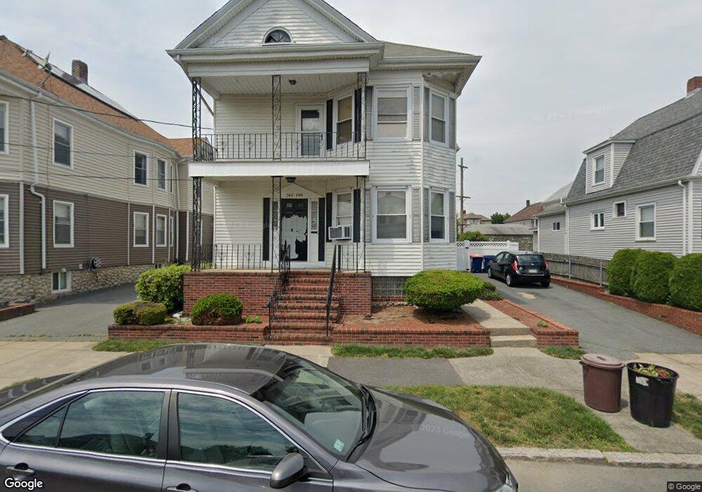
199 Hersom St Unit 201 New Bedford, MA 02745
Acushnet Station NeighborhoodEstimated Value: $453,692 - $563,000
6
Beds
2
Baths
2,352
Sq Ft
$219/Sq Ft
Est. Value
About This Home
This home is located at 199 Hersom St Unit 201, New Bedford, MA 02745 and is currently estimated at $516,173, approximately $219 per square foot. 199 Hersom St Unit 201 is a home located in Bristol County with nearby schools including Jireh Swift School, Normandin Middle School, and New Bedford High School.
Ownership History
Date
Name
Owned For
Owner Type
Purchase Details
Closed on
Nov 16, 2018
Sold by
Fernandes Dorothy
Bought by
Fernandes Ft and Fernandes
Current Estimated Value
Purchase Details
Closed on
Nov 24, 1999
Sold by
Leblanc Joseph D and Leblanc Lorraine C
Bought by
Burke Carol
Home Financials for this Owner
Home Financials are based on the most recent Mortgage that was taken out on this home.
Original Mortgage
$35,000
Interest Rate
7.77%
Mortgage Type
Purchase Money Mortgage
Create a Home Valuation Report for This Property
The Home Valuation Report is an in-depth analysis detailing your home's value as well as a comparison with similar homes in the area
Home Values in the Area
Average Home Value in this Area
Purchase History
| Date | Buyer | Sale Price | Title Company |
|---|---|---|---|
| Fernandes Ft | -- | -- | |
| Fernandes Ft | -- | -- | |
| Burke Carol | $130,000 | -- | |
| Burke Carol | $130,000 | -- |
Source: Public Records
Mortgage History
| Date | Status | Borrower | Loan Amount |
|---|---|---|---|
| Previous Owner | Burke Carol | $35,000 | |
| Previous Owner | Burke Carol | $80,000 |
Source: Public Records
Tax History
| Year | Tax Paid | Tax Assessment Tax Assessment Total Assessment is a certain percentage of the fair market value that is determined by local assessors to be the total taxable value of land and additions on the property. | Land | Improvement |
|---|---|---|---|---|
| 2025 | $4,849 | $428,700 | $111,800 | $316,900 |
| 2024 | $4,306 | $358,800 | $111,800 | $247,000 |
| 2023 | $3,958 | $277,000 | $89,800 | $187,200 |
| 2022 | $3,613 | $232,500 | $85,500 | $147,000 |
| 2021 | $3,625 | $232,500 | $85,500 | $147,000 |
| 2020 | $3,657 | $226,300 | $85,500 | $140,800 |
| 2019 | $3,590 | $218,000 | $85,500 | $132,500 |
| 2018 | $3,441 | $206,900 | $85,500 | $121,400 |
| 2017 | $3,108 | $186,200 | $82,200 | $104,000 |
| 2016 | $2,943 | $178,500 | $78,900 | $99,600 |
| 2015 | $2,754 | $175,100 | $78,900 | $96,200 |
| 2014 | $2,614 | $172,400 | $75,700 | $96,700 |
Source: Public Records
Map
Nearby Homes
- 197 Hersom St
- 203 Hersom St Unit 205
- 203 Hersom St Unit 1
- 205 Hersom St Unit 2
- 46 Branscomb St Unit 48
- 193 Hersom St Unit 195
- 209 Hersom St Unit 211
- 36 Branscomb St Unit 38
- 58 Branscomb St
- 200 Hersom St
- 196 Hersom St
- 204 Hersom St
- 215 Hersom St
- 32 Branscomb St Unit 34
- 210 Hersom St
- 79 Fielding St
- 214 Hersom St
- 53 Fielding St
- 43 Branscomb St Unit 45
- 28 Branscomb St Unit 30
Your Personal Tour Guide
Ask me questions while you tour the home.