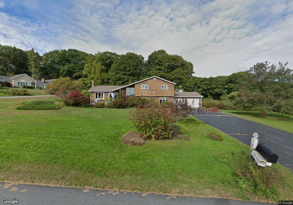
2 Ebb Tide Dr Cumberland Foreside, ME 04110
Cumberland Foreside NeighborhoodEstimated Value: $910,000 - $1,159,000
About This Home
This home is located at 2 Ebb Tide Dr, Cumberland Foreside, ME 04110 and is currently estimated at $1,060,501, approximately $473 per square foot. 2 Ebb Tide Dr is a home located in Cumberland County with nearby schools including Mabel I. Wilson School, Greely Middle School 4-5, and Greely Middle School.
Ownership History
We collect this data history from publicly available records. To have your information removed, we recommend requesting removal directly through your county’s website.
Purchase Details
Home Values in the Area
Average Home Value in this Area
Purchase History
We collect this data history from publicly available records. To have your information removed, we recommend requesting removal directly through your county’s website.
| Date | Buyer | Sale Price | Title Company |
|---|---|---|---|
| -- | -- | ||
| -- | -- | ||
| -- | -- |
Mortgage History
We collect this data history from publicly available records. To have your information removed, we recommend requesting removal directly through your county’s website.
| Date | Status | Borrower | Loan Amount |
|---|---|---|---|
| Previous Owner | $300,000 |
Tax History
We collect this data history from publicly available records. To have your information removed, we recommend requesting removal directly through your county’s website.
| Year | Tax Paid | Tax Assessment Tax Assessment Total Assessment is a certain percentage of the fair market value that is determined by local assessors to be the total taxable value of land and additions on the property. | Land | Improvement |
|---|---|---|---|---|
| 2025 | $14,232 | $565,200 | $431,400 | $133,800 |
| 2024 | $13,141 | $565,200 | $431,400 | $133,800 |
| 2023 | $12,519 | $565,200 | $431,400 | $133,800 |
| 2022 | $11,982 | $565,200 | $431,400 | $133,800 |
| 2021 | $11,615 | $565,200 | $431,400 | $133,800 |
| 2020 | $11,502 | $565,200 | $431,400 | $133,800 |
| 2019 | $11,219 | $565,200 | $431,400 | $133,800 |
| 2018 | $11,056 | $561,200 | $431,400 | $129,800 |
| 2017 | $10,551 | $561,200 | $431,400 | $129,800 |
| 2016 | $10,242 | $561,200 | $431,400 | $129,800 |
| 2015 | $10,154 | $561,000 | $431,400 | $129,600 |
| 2014 | $9,761 | $561,000 | $431,400 | $129,600 |
| 2013 | $9,537 | $561,000 | $431,400 | $129,600 |
Map
- 0 Ravine Dr Unit 1652137
- 135 Fairwind Ln
- 9 Sea Spray Reach
- 22 Schooner Ridge Rd
- 36 Merrill Dr Unit 36
- 492 W Elm St
- 18 Greely Rd
- 54 Royall Point Rd
- 6 Daybreak Ln Unit 18
- 23 Portland St
- 52 Blueberry Cove Rd Unit 52
- 109 Main St
- 143 Royall Point Rd
- 15 Blueberry Cove
- 32 Acorn Cir
- 98 Harborview Dr
- 37 South St
- 298 Main St Unit 2E
- 298 Main St Unit 3G
- 298 Main St Unit 2F
- 4 Ebb Tide Dr
- 1 Ebb Tide Dr
- 10 Island View Dr
- 8 Island View Dr
- 1 Island View Dr
- 6 Island View Dr
- 2 Broad Cove Way
- 5 Island View Dr
- 2 Island View Dr
- 5 Ebb Tide Dr
- 326 Foreside Rd
- 10 Ebb Tide Dr
- 37 Broad Cove Woods
- 2 Broad Cove Way
- 30 Fern Ln
- 7 Ebb Tide Dr
- 671 Lafayette St
- 7 Broad Cove Woods
- 8 Broad Cove Way
- 47 Broad Cove Woods
Ask me questions while you tour the home.