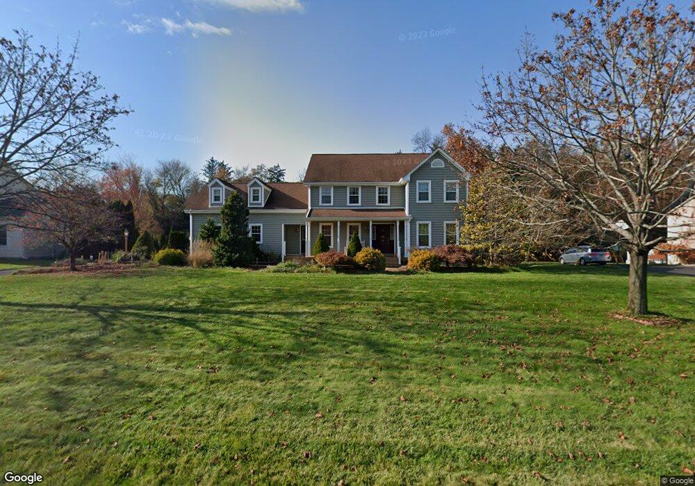
20 Gilbert Ln South Windsor, CT 06074
Estimated Value: $733,270 - $796,000
3
Beds
3
Baths
2,876
Sq Ft
$266/Sq Ft
Est. Value
About This Home
This home is located at 20 Gilbert Ln, South Windsor, CT 06074 and is currently estimated at $764,568, approximately $265 per square foot. 20 Gilbert Ln is a home located in Hartford County with nearby schools including Timothy Edwards School, South Windsor High School, and Odyssey Community School.
Ownership History
Date
Name
Owned For
Owner Type
Purchase Details
Closed on
May 23, 2019
Sold by
Anastasi Anthony F and Anastasi Almudena P
Bought by
Sekhar-Nayak Himadri
Current Estimated Value
Home Financials for this Owner
Home Financials are based on the most recent Mortgage that was taken out on this home.
Original Mortgage
$418,500
Outstanding Balance
$366,431
Interest Rate
4.1%
Mortgage Type
Purchase Money Mortgage
Estimated Equity
$398,137
Purchase Details
Closed on
Jul 23, 1999
Sold by
Clark Realty Inc
Bought by
Anastasi Anthony and Anastasi Almudena
Home Financials for this Owner
Home Financials are based on the most recent Mortgage that was taken out on this home.
Original Mortgage
$100,000
Interest Rate
7.49%
Create a Home Valuation Report for This Property
The Home Valuation Report is an in-depth analysis detailing your home's value as well as a comparison with similar homes in the area
Home Values in the Area
Average Home Value in this Area
Purchase History
| Date | Buyer | Sale Price | Title Company |
|---|---|---|---|
| Sekhar-Nayak Himadri | $450,000 | -- | |
| Anastasi Anthony | $242,100 | -- |
Source: Public Records
Mortgage History
| Date | Status | Borrower | Loan Amount |
|---|---|---|---|
| Open | Sekhar-Nayak Himadri | $418,500 | |
| Previous Owner | Anastasi Anthony | $162,480 | |
| Previous Owner | Anastasi Anthony | $115,730 | |
| Previous Owner | Anastasi Anthony | $100,000 |
Source: Public Records
Tax History
| Year | Tax Paid | Tax Assessment Tax Assessment Total Assessment is a certain percentage of the fair market value that is determined by local assessors to be the total taxable value of land and additions on the property. | Land | Improvement |
|---|---|---|---|---|
| 2025 | $14,191 | $398,500 | $119,700 | $278,800 |
| 2024 | $13,732 | $398,500 | $119,700 | $278,800 |
| 2023 | $13,206 | $398,500 | $119,700 | $278,800 |
| 2022 | $11,701 | $301,800 | $110,200 | $191,600 |
| 2021 | $11,426 | $301,800 | $110,200 | $191,600 |
| 2020 | $11,432 | $301,800 | $110,200 | $191,600 |
| 2019 | $11,354 | $294,900 | $110,200 | $184,700 |
| 2018 | $11,109 | $294,900 | $110,200 | $184,700 |
| 2017 | $10,659 | $279,900 | $110,200 | $169,700 |
| 2016 | $10,451 | $279,900 | $110,200 | $169,700 |
| 2015 | $10,228 | $279,900 | $110,200 | $169,700 |
| 2014 | $9,939 | $279,900 | $110,200 | $169,700 |
Source: Public Records
Map
Nearby Homes
- 112 Gilbert Ln
- 36 Cardinal Way
- 33 Imperial Dr
- 47 Nolan Cir Unit 47
- 46 Donahue Ln Unit 46
- 13 Oak Forest Dr Unit 6
- 100 Misty Meadow Ln Unit 100
- 804 Sand Stone Dr
- 307 Clark St
- 82 Cinnamon Springs
- 1503 Summer Hill Dr
- 1301 Summer Hill Dr
- 506 Summer Hill Dr Unit 506
- 104 Carman Rd
- 1106 Summer Hill Dr
- 1004 Summer Hill Dr
- 348 Avery St
- 49 Deepwood Dr
- 83 Candlewood Dr Unit 83
- 62 Candlewood Dr Unit 62
Your Personal Tour Guide
Ask me questions while you tour the home.