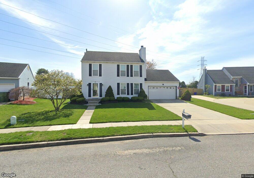
20 Pickwick Dr Marlton, NJ 08053
Estimated Value: $494,000 - $527,000
Studio
--
Bath
1,718
Sq Ft
$294/Sq Ft
Est. Value
About This Home
This home is located at 20 Pickwick Dr, Marlton, NJ 08053 and is currently estimated at $505,011, approximately $293 per square foot. 20 Pickwick Dr is a home located in Burlington County with nearby schools including J. Harold Vanzant Elementary School, Frances Demasi Middle School, and Cherokee High School.
Ownership History
Date
Name
Owned For
Owner Type
Purchase Details
Closed on
Jun 18, 2004
Sold by
Johns Rodney M
Bought by
Briggs Daniel S and Briggs Heather K
Current Estimated Value
Home Financials for this Owner
Home Financials are based on the most recent Mortgage that was taken out on this home.
Original Mortgage
$205,500
Interest Rate
6.32%
Mortgage Type
Purchase Money Mortgage
Purchase Details
Closed on
Jul 16, 2001
Sold by
Anderson Richard L and Anderson Kellie E
Bought by
Johns Rodney M and Johns Xenia L
Home Financials for this Owner
Home Financials are based on the most recent Mortgage that was taken out on this home.
Original Mortgage
$190,550
Interest Rate
7.18%
Mortgage Type
VA
Purchase Details
Closed on
Feb 4, 1998
Sold by
Holmes Roswell D and Holmes Kimberly A
Bought by
Anderson Richard and Anderson Kellie
Home Financials for this Owner
Home Financials are based on the most recent Mortgage that was taken out on this home.
Original Mortgage
$128,000
Interest Rate
6%
Create a Home Valuation Report for This Property
The Home Valuation Report is an in-depth analysis detailing your home's value as well as a comparison with similar homes in the area
Home Values in the Area
Average Home Value in this Area
Purchase History
| Date | Buyer | Sale Price | Title Company |
|---|---|---|---|
| Briggs Daniel S | $265,500 | -- | |
| Johns Rodney M | $185,000 | -- | |
| Anderson Richard | $148,000 | -- |
Source: Public Records
Mortgage History
| Date | Status | Borrower | Loan Amount |
|---|---|---|---|
| Closed | Briggs Daniel S | $205,500 | |
| Previous Owner | Johns Rodney M | $190,550 | |
| Previous Owner | Anderson Richard | $128,000 |
Source: Public Records
Tax History
| Year | Tax Paid | Tax Assessment Tax Assessment Total Assessment is a certain percentage of the fair market value that is determined by local assessors to be the total taxable value of land and additions on the property. | Land | Improvement |
|---|---|---|---|---|
| 2025 | $9,603 | $281,200 | $100,000 | $181,200 |
| 2024 | $9,035 | $281,200 | $100,000 | $181,200 |
| 2023 | $9,035 | $281,200 | $100,000 | $181,200 |
| 2022 | $8,630 | $281,200 | $100,000 | $181,200 |
| 2021 | $8,428 | $281,200 | $100,000 | $181,200 |
| 2020 | $8,318 | $281,200 | $100,000 | $181,200 |
| 2019 | $8,250 | $281,200 | $100,000 | $181,200 |
| 2018 | $8,135 | $281,200 | $100,000 | $181,200 |
| 2017 | $8,040 | $281,200 | $100,000 | $181,200 |
| 2016 | $7,843 | $281,200 | $100,000 | $181,200 |
| 2015 | $7,705 | $281,200 | $100,000 | $181,200 |
| 2014 | $7,486 | $281,200 | $100,000 | $181,200 |
Source: Public Records
Map
Nearby Homes
- 8 Heron Pointe Ct
- 14 Chablis Ct
- 377 N Locust Ave
- 9 Merlot Ct
- 32 Hearthstone Ln
- 73 Hearthstone Ln
- 4510 Church Rd
- 1 Bergan Ct
- 53 Lexington Cir
- 13 Faybrooke Dr
- 305A Kelly Cove Unit 309
- 81A N Locust Ave
- 81B N Locust Ave Unit A
- 81 N Locust Ave Unit A
- 305 A Cypress Point Cir
- 139 Ramsey Ave
- 213 Augusta Cir
- 210 Augusta Cir Unit 210
- 308 Mallard Dr
- 6 Kingsley Ave
Your Personal Tour Guide
Ask me questions while you tour the home.