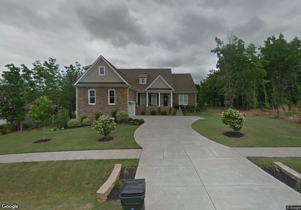
20 Pointe View Way Franklinton, NC 27525
Estimated Value: $491,000 - $673,000
4
Beds
4
Baths
3,913
Sq Ft
$149/Sq Ft
Est. Value
About This Home
This home is located at 20 Pointe View Way, Franklinton, NC 27525 and is currently estimated at $584,927, approximately $149 per square foot. 20 Pointe View Way is a home located in Franklin County with nearby schools including Long Mill Elementary, Franklinton Middle School, and Franklinton High School.
Ownership History
Date
Name
Owned For
Owner Type
Purchase Details
Closed on
Apr 28, 2011
Sold by
Trustatlantic Bank
Bought by
King John and King Pamela
Current Estimated Value
Home Financials for this Owner
Home Financials are based on the most recent Mortgage that was taken out on this home.
Original Mortgage
$223,200
Outstanding Balance
$152,999
Interest Rate
4.74%
Mortgage Type
New Conventional
Estimated Equity
$431,928
Create a Home Valuation Report for This Property
The Home Valuation Report is an in-depth analysis detailing your home's value as well as a comparison with similar homes in the area
Home Values in the Area
Average Home Value in this Area
Purchase History
| Date | Buyer | Sale Price | Title Company |
|---|---|---|---|
| King John | $279,000 | None Available | |
| King John | $279,000 | None Available |
Source: Public Records
Mortgage History
| Date | Status | Borrower | Loan Amount |
|---|---|---|---|
| Open | King John | $223,200 |
Source: Public Records
Tax History
| Year | Tax Paid | Tax Assessment Tax Assessment Total Assessment is a certain percentage of the fair market value that is determined by local assessors to be the total taxable value of land and additions on the property. | Land | Improvement |
|---|---|---|---|---|
| 2025 | $3,708 | $594,940 | $92,000 | $502,940 |
| 2024 | $3,639 | $594,940 | $92,000 | $502,940 |
| 2023 | $3,830 | $422,440 | $75,600 | $346,840 |
| 2022 | $3,820 | $422,440 | $75,600 | $346,840 |
| 2021 | $3,839 | $422,440 | $75,600 | $346,840 |
| 2020 | $3,862 | $422,440 | $75,600 | $346,840 |
| 2019 | $3,852 | $422,440 | $75,600 | $346,840 |
| 2018 | $3,826 | $422,440 | $75,600 | $346,840 |
| 2017 | $3,526 | $353,370 | $42,000 | $311,370 |
| 2016 | $3,649 | $353,370 | $42,000 | $311,370 |
| 2015 | $3,649 | $353,370 | $42,000 | $311,370 |
| 2014 | $3,439 | $353,370 | $42,000 | $311,370 |
Source: Public Records
Map
Nearby Homes
- 45 Point View Way
- 815 Harmony Ranch Ln
- 110 Point View Way
- 535 Long View Dr
- 100 N Ridge View Way
- 590 Long View Dr
- 130 N Ridge View Way
- 120 Clubhouse Dr
- 30 Waterview Way
- 225 Clubhouse Dr
- 355 Ashberry Ln
- 60 Waterview Way
- 120 Sutherland Dr
- 295 Clubhouse Dr
- 210 Gallery Park Dr
- 235 Ashberry Ln
- 115 Old Garden Ln
- 155 Meadow Lake Dr
- 30 Junius Birch Trail
- 145 Vast View Way
- 20 Point View Way
- 30 Pointe View Way
- 30 Point View Way
- 10 Point View Way
- 40 Point View Way
- 25 Point View Way Unit Estates Lot 723
- 15 Pointe View Way
- 15 Point View Way
- 35 Point View Way
- 35 Point View Way Unit 722
- 35 Pointe View Way
- 50 Point View Way
- 65 Grand Fairway Dr
- 65 Grand Fairway Dr
- 25 N Ridge View Way
- 25 N Ridge View Way Unit Estates Lot 683
- 15 N Ridge View Way Unit 684
- 15 N Ridge View Way
- 35 N Ridge View Way Unit 682 OLE
- 55 Point View Way
Your Personal Tour Guide
Ask me questions while you tour the home.