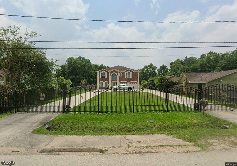
2002 Skinner Rd Houston, TX 77093
Eastex-Jensen NeighborhoodEstimated Value: $517,000 - $739,845
4
Beds
4
Baths
4,632
Sq Ft
$132/Sq Ft
Est. Value
About This Home
This home is located at 2002 Skinner Rd, Houston, TX 77093 and is currently estimated at $609,211, approximately $131 per square foot. 2002 Skinner Rd is a home located in Harris County with nearby schools including Coop Elementary School, Patrick Henry Middle School, and Sam Houston Math, Science & Technology Center.
Ownership History
Date
Name
Owned For
Owner Type
Purchase Details
Closed on
Jun 10, 2008
Sold by
Perez Jose Alberto and Perez Patsy Ann
Bought by
Resendiz Jose and Resendiz Anna
Current Estimated Value
Home Financials for this Owner
Home Financials are based on the most recent Mortgage that was taken out on this home.
Original Mortgage
$25,000
Interest Rate
5.99%
Mortgage Type
Seller Take Back
Purchase Details
Closed on
Nov 14, 2003
Sold by
Malone Hong Yen Thi and Nguyen Yen Thi Hong
Bought by
Perez Patsy Ann and Perez Jose Alberto
Create a Home Valuation Report for This Property
The Home Valuation Report is an in-depth analysis detailing your home's value as well as a comparison with similar homes in the area
Home Values in the Area
Average Home Value in this Area
Purchase History
| Date | Buyer | Sale Price | Title Company |
|---|---|---|---|
| Resendiz Jose | -- | American Title Company | |
| Perez Patsy Ann | -- | -- |
Source: Public Records
Mortgage History
| Date | Status | Borrower | Loan Amount |
|---|---|---|---|
| Closed | Resendiz Jose | $25,000 |
Source: Public Records
Tax History
| Year | Tax Paid | Tax Assessment Tax Assessment Total Assessment is a certain percentage of the fair market value that is determined by local assessors to be the total taxable value of land and additions on the property. | Land | Improvement |
|---|---|---|---|---|
| 2025 | $10,198 | $716,703 | $327,488 | $389,215 |
| 2024 | $10,198 | $897,743 | $306,720 | $591,023 |
| 2023 | $10,198 | $600,000 | $115,659 | $484,341 |
| 2022 | $12,865 | $606,107 | $199,688 | $406,419 |
| 2021 | $12,379 | $531,137 | $143,775 | $387,362 |
| 2020 | $11,720 | $502,902 | $143,775 | $359,127 |
| 2019 | $11,134 | $502,902 | $143,775 | $359,127 |
| 2018 | $7,836 | $400,000 | $110,228 | $289,772 |
| 2017 | $9,332 | $400,000 | $110,228 | $289,772 |
| 2016 | $8,483 | $400,000 | $110,228 | $289,772 |
| 2015 | $6,125 | $305,000 | $87,863 | $217,137 |
| 2014 | $6,125 | $305,000 | $87,863 | $217,137 |
Source: Public Records
Map
Nearby Homes
- 2306 Langley Rd
- 2315 Langley Rd
- 2332 Margaret St
- 1717 Cresline St
- 2411 Charles Rd Unit A
- 2522 Kowis St
- 2414 Lone Oak Rd
- 2318 Cresline St
- 2430 Lone Oak Rd Unit 1
- 2502 Lone Oak Rd
- 2506 Lone Oak Rd
- 2512 Lone Oak Rd
- 9907 & 9909 Exeter St
- 1002 Grenfell Ln
- 2523 Lone Oak Rd
- 2527 Lone Oak Rd
- 1805 Chamberlain St
- 0 Kowis
- 2530 Kowis St
- 2636 Lone Oak Rd
- 2006 Skinner Rd
- 1934 Skinner Rd
- 2008 Skinner Rd
- 1918 Skinner Rd
- 1910 Skinner Rd
- 1913 Skinner Rd
- 2035 Skinner Rd
- 2014 Skinner Rd
- 1909 Skinner Rd
- 1902 Skinner Rd
- 1903 Skinner Rd
- 2005 Skinner
- 2031 Skinner Rd
- 10604 Exeter St
- 10608 Exeter St
- 1931 Margaret St
- 1925 Margaret St
- 2038 Skinner Rd
- 10522 Exeter St
- 10565 Exeter St
Your Personal Tour Guide
Ask me questions while you tour the home.