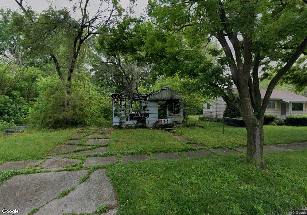
2005 Kentucky Ave Flint, MI 48506
Eastside NeighborhoodEstimated Value: $34,000 - $57,000
2
Beds
1
Bath
734
Sq Ft
$63/Sq Ft
Est. Value
About This Home
This home is located at 2005 Kentucky Ave, Flint, MI 48506 and is currently estimated at $46,069, approximately $62 per square foot. 2005 Kentucky Ave is a home located in Genesee County with nearby schools including Potter School, Flint Cultural Center Academy, and WAY Academy of Flint.
Ownership History
Date
Name
Owned For
Owner Type
Purchase Details
Closed on
Dec 20, 2022
Sold by
Genesee County Treasurer
Bought by
Genesee County Land Bank Authority
Current Estimated Value
Purchase Details
Closed on
Apr 26, 2022
Sold by
Clayton Cornwell
Bought by
Genesee County Treasurer
Purchase Details
Closed on
Oct 20, 2016
Sold by
Pretznow Ian and Pretznow Alexia
Bought by
Cornwell Clayton
Purchase Details
Closed on
Oct 18, 1999
Sold by
Lohnes M
Bought by
Pretznow Ian
Home Financials for this Owner
Home Financials are based on the most recent Mortgage that was taken out on this home.
Original Mortgage
$33,000
Interest Rate
8%
Mortgage Type
Purchase Money Mortgage
Create a Home Valuation Report for This Property
The Home Valuation Report is an in-depth analysis detailing your home's value as well as a comparison with similar homes in the area
Home Values in the Area
Average Home Value in this Area
Purchase History
| Date | Buyer | Sale Price | Title Company |
|---|---|---|---|
| Genesee County Land Bank Authority | -- | -- | |
| Genesee County Treasurer | -- | -- | |
| Cornwell Clayton | $5,000 | Cislo Title Co | |
| Pretznow Ian | $33,000 | -- |
Source: Public Records
Mortgage History
| Date | Status | Borrower | Loan Amount |
|---|---|---|---|
| Previous Owner | Pretznow Ian | $33,000 |
Source: Public Records
Tax History
| Year | Tax Paid | Tax Assessment Tax Assessment Total Assessment is a certain percentage of the fair market value that is determined by local assessors to be the total taxable value of land and additions on the property. | Land | Improvement |
|---|---|---|---|---|
| 2025 | -- | $0 | $0 | $0 |
| 2024 | -- | $0 | $0 | $0 |
| 2023 | -- | $0 | $0 | $0 |
| 2022 | $0 | $2,400 | $0 | $0 |
| 2021 | $401 | $3,200 | $0 | $0 |
| 2020 | $557 | $7,600 | $0 | $0 |
| 2019 | $1,055 | $6,000 | $0 | $0 |
| 2018 | $553 | $6,700 | $0 | $0 |
| 2017 | $541 | $0 | $0 | $0 |
| 2016 | $628 | $0 | $0 | $0 |
| 2015 | -- | $0 | $0 | $0 |
| 2014 | -- | $0 | $0 | $0 |
| 2012 | -- | $8,000 | $0 | $0 |
Source: Public Records
Map
Nearby Homes
- 1318 Cronk Ave
- 1501 Arlington Ave
- 2218 Kentucky Ave
- 2301 Missouri Ave
- 2302 Missouri Ave
- 1216 Minnesota Ave
- 1724 Ohio Ave
- 2433 Pennsylvania Ave
- 1609 Ohio Ave
- 2605 Nebraska Ave
- 2428 Illinois Ave
- 301 Chandler St
- 2610 Pennsylvania Ave
- 2601 Illinois Ave
- 1540 Illinois Ave
- 151 Commonwealth Ave
- 2105 Arlington Ave
- 434 Chalmers St
- 2426 Broadway Blvd
- 1805 Bennett Ave
- 2001 Kentucky Ave
- 2013 Kentucky Ave
- 1921 Kentucky Ave
- 2006 Missouri Ave
- 2010 Missouri Ave
- 2002 Missouri Ave
- 2017 Kentucky Ave
- 1917 Kentucky Ave
- 2014 Missouri Ave
- 1922 Missouri Ave
- 2018 Missouri Ave
- 2021 Kentucky Ave
- 1918 Missouri Ave
- 1913 Kentucky Ave
- 2006 Kentucky Ave
- 2002 Kentucky Ave
- 2010 Kentucky Ave
- 2014 Kentucky Ave
- 1922 Kentucky Ave
- 2022 Missouri Ave
Your Personal Tour Guide
Ask me questions while you tour the home.