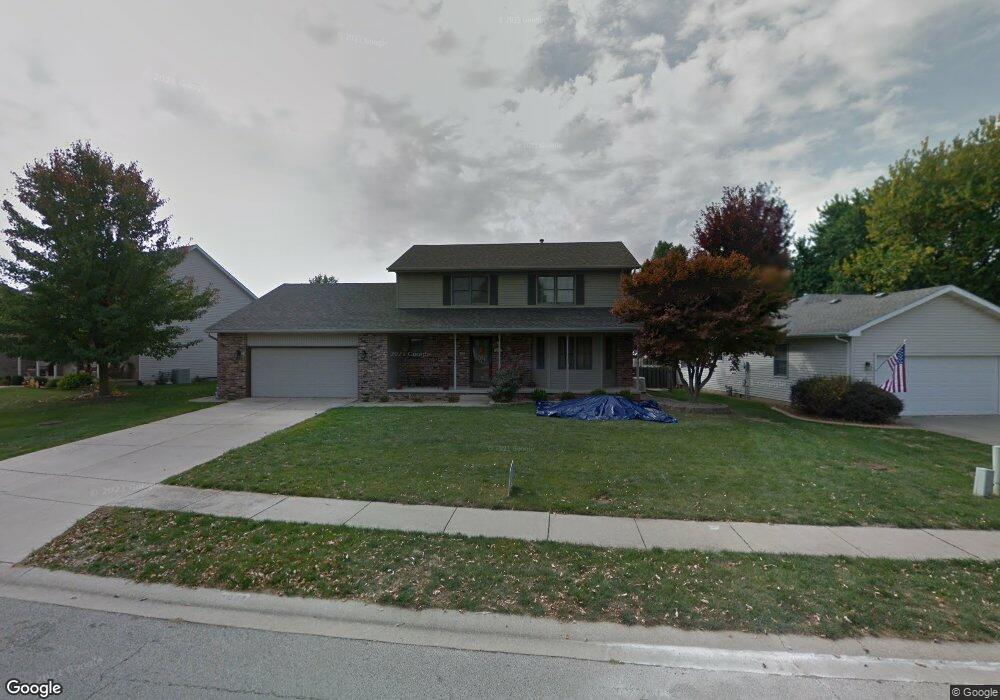
2009 Burgess Dr Springfield, IL 62711
Estimated Value: $292,000 - $369,000
Studio
--
Bath
--
Sq Ft
11,631
Sq Ft Lot
About This Home
This home is located at 2009 Burgess Dr, Springfield, IL 62711 and is currently estimated at $338,978. 2009 Burgess Dr is a home located in Sangamon County with nearby schools including Lindsay School, U.S. Grant Middle School, and Springfield High School.
Ownership History
Date
Name
Owned For
Owner Type
Purchase Details
Closed on
Jun 27, 2008
Current Estimated Value
Purchase Details
Closed on
Nov 9, 2007
Purchase Details
Closed on
Jun 26, 2006
Purchase Details
Closed on
Jun 23, 2004
Purchase Details
Closed on
Aug 8, 2000
Purchase Details
Closed on
Feb 25, 1999
Purchase Details
Closed on
Oct 23, 1996
Purchase Details
Closed on
Apr 16, 1996
Create a Home Valuation Report for This Property
The Home Valuation Report is an in-depth analysis detailing your home's value as well as a comparison with similar homes in the area
Purchase History
| Date | Buyer | Sale Price | Title Company |
|---|---|---|---|
| -- | $192,000 | -- | |
| -- | -- | -- | |
| -- | -- | -- | |
| -- | $186,000 | -- | |
| -- | -- | -- | |
| -- | $167,000 | -- | |
| -- | $155,000 | -- | |
| -- | $28,300 | -- |
Source: Public Records
Tax History
| Year | Tax Paid | Tax Assessment Tax Assessment Total Assessment is a certain percentage of the fair market value that is determined by local assessors to be the total taxable value of land and additions on the property. | Land | Improvement |
|---|---|---|---|---|
| 2024 | $7,268 | $98,833 | $14,887 | $83,946 |
| 2023 | $7,339 | $90,275 | $13,598 | $76,677 |
| 2022 | $6,982 | $85,105 | $12,898 | $72,207 |
| 2021 | $6,731 | $81,918 | $12,415 | $69,503 |
| 2020 | $6,599 | $82,041 | $12,434 | $69,607 |
| 2019 | $6,475 | $81,755 | $12,391 | $69,364 |
| 2018 | $5,614 | $73,424 | $12,331 | $61,093 |
| 2017 | $5,491 | $72,475 | $12,172 | $60,303 |
| 2016 | $5,377 | $71,418 | $11,994 | $59,424 |
| 2015 | $5,319 | $70,565 | $11,851 | $58,714 |
| 2014 | $4,979 | $70,109 | $11,774 | $58,335 |
| 2013 | $4,869 | $66,969 | $11,774 | $55,195 |
Source: Public Records
Map
Nearby Homes
- 4521 Barrington Dr
- LOT 54 Chestnut Dr
- 1621 Briarcreek Ln
- 1412 Winston Dr
- 5404 Jaeger Dr
- 2311 Asheville Dr
- 4117 Gaskell Dr
- 6013 Hedley Rd
- 5904 Hedley Rd
- 2612 Dickens Dr
- 3908 Waterstone Way
- 2862 Reseda Rd Unit LOT16
- 4568 Old Jacksonville Rd
- 5225 Jade Ln Unit LOT19
- 3924 Old Mill Ln
- 5301 Jade Ln Unit LOT20
- 5220 Jade Ln Unit LOT39
- 2104 Dubsdread Dr
- 5305 Jade Ln Unit LOT21
- 5224 Jade Ln Unit LOT38
- 2005 Burgess Dr
- 2101 Burgess Dr
- 2105 Burgess Dr
- 2012 Burgess Dr
- 2100 Burgess Dr
- 2008 Burgess Dr
- 4640 Barrington Dr
- 2104 Burgess Dr
- 4644 Barrington Dr
- 2004 Palo Alto Dr
- 2008 Palo Alto Dr
- 2004 Burgess Dr
- 2109 Burgess Dr
- 4648 Barrington Dr
- 4632 Barrington Dr
- 2108 Burgess Dr
- 2100 Palo Alto Dr
- 2000 Palo Alto Dr
- 2013 Redlands Dr
- 2101 Redlands Dr
Your Personal Tour Guide
Ask me questions while you tour the home.