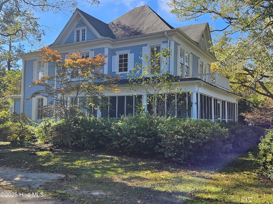
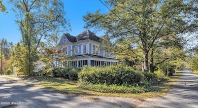
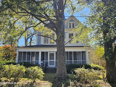
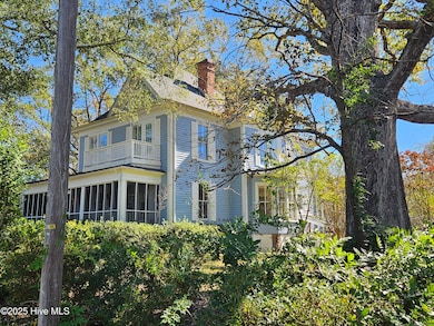
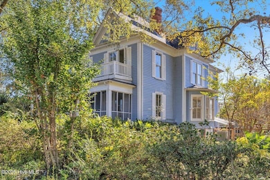
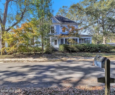
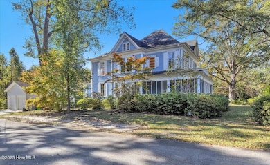
201 W Main St Atkinson, NC 28421
Estimated payment $1,723/month
Highlights
- Hot Property
- Deck
- Main Floor Primary Bedroom
- The property is located in a historic district
- Wood Flooring
- Corner Lot
About This Home
PRICE IMPROVEMENT! MOTIVATED SELLER! Welcome to The Johnson-Woodcock- Shaffer House located within the Atkinson NC Historic district. This stately 1911 Queen Ann Victorian features 5 bedrooms, 2.5 baths, all formal areas, a walk out basement & 9 fireplaces. Master bedroom is on the first floor with the remaining 4 upstairs.
The property consists of 2 parcels totaling .86 acres of beautiful mature landscaping. 2 car detached garage, fenced yard Atkinson NC is located in western Pender County just 45 minutes to Wilmington, NC & its beaches, 25 minutes to Burgaw, NC & 30 minutes to White Lake/Elizabethtown, NC
House does need some work to bring her back to her original glory & is being sold as is. Shown by appointment only
Home Details
Home Type
- Single Family
Est. Annual Taxes
- $1,345
Year Built
- Built in 1911
Lot Details
- 37,500 Sq Ft Lot
- Lot Dimensions are 250x150
- Property fronts a state road
- Property is Fully Fenced
- Wire Fence
- Corner Lot
- Property is zoned R-12
Parking
- 2 Car Detached Garage
Home Design
- Shingle Roof
- Wood Siding
Interior Spaces
- 3,040 Sq Ft Home
- 2-Story Property
- Furnished or left unfurnished upon request
- High Ceiling
- Ceiling Fan
- Fireplace
- Mud Room
- Entrance Foyer
- Living Room
- Dining Room
- Den
- Utility Room
- Laundry Room
- Pull Down Stairs to Attic
Kitchen
- Range
- Dishwasher
- Solid Surface Countertops
Flooring
- Wood
- Tile
Bedrooms and Bathrooms
- 5 Bedrooms
- Primary Bedroom on Main
- Walk-in Shower
Partially Finished Basement
- Exterior Basement Entry
- Crawl Space
Outdoor Features
- Balcony
- Deck
- Screened Patio
- Wrap Around Porch
Location
- The property is located in a historic district
Schools
- Malpass Corner Elementary School
- West Pender Middle School
- Pender High School
Utilities
- Whole House Fan
- Heating Available
- Electric Water Heater
- Municipal Trash
Community Details
- No Home Owners Association
Listing and Financial Details
- Tax Lot BLK 18 Lt 8
- Assessor Parcel Number 2248-93-7544-0000
Map
Home Values in the Area
Average Home Value in this Area
Tax History
| Year | Tax Paid | Tax Assessment Tax Assessment Total Assessment is a certain percentage of the fair market value that is determined by local assessors to be the total taxable value of land and additions on the property. | Land | Improvement |
|---|---|---|---|---|
| 2025 | $1,356 | $285,311 | $29,596 | $255,715 |
| 2024 | $1,355 | $95,619 | $18,115 | $77,504 |
| 2023 | $1,231 | $95,619 | $18,115 | $77,504 |
| 2022 | $1,231 | $95,619 | $18,115 | $77,504 |
| 2021 | $1,231 | $95,619 | $18,115 | $77,504 |
| 2020 | $1,231 | $95,619 | $18,115 | $77,504 |
| 2019 | $1,247 | $95,619 | $18,115 | $77,504 |
| 2018 | $985 | $69,490 | $10,600 | $58,890 |
| 2017 | $985 | $69,490 | $10,600 | $58,890 |
| 2016 | $978 | $69,490 | $10,600 | $58,890 |
| 2015 | $978 | $69,490 | $10,600 | $58,890 |
| 2014 | $848 | $69,490 | $10,600 | $58,890 |
| 2013 | -- | $69,490 | $10,600 | $58,890 |
| 2012 | -- | $69,490 | $10,600 | $58,890 |
Property History
| Date | Event | Price | List to Sale | Price per Sq Ft |
|---|---|---|---|---|
| 03/24/2026 03/24/26 | Price Changed | $299,000 | -8.0% | $98 / Sq Ft |
| 02/07/2026 02/07/26 | Price Changed | $325,000 | -6.9% | $107 / Sq Ft |
| 12/12/2025 12/12/25 | Off Market | $349,000 | -- | -- |
| 12/01/2025 12/01/25 | For Sale | $349,000 | 0.0% | $115 / Sq Ft |
| 12/01/2025 12/01/25 | Price Changed | $349,000 | -7.9% | $115 / Sq Ft |
| 11/14/2025 11/14/25 | Price Changed | $379,000 | -5.2% | $125 / Sq Ft |
| 10/25/2025 10/25/25 | For Sale | $399,999 | -- | $132 / Sq Ft |
Purchase History
| Date | Type | Sale Price | Title Company |
|---|---|---|---|
| Deed | $195,000 | -- |
Mortgage History
| Date | Status | Loan Amount | Loan Type |
|---|---|---|---|
| Closed | $174,000 | Unknown |
Source: Hive MLS
MLS Number: 100538101
APN: 2248-93-7544-0000
Disclaimer: Certain information contained herein is derived from information provided by parties other than Homes.com. All information provided is deemed reliable, but is not guaranteed to be accurate and should be independently verified.
![]() The data relating to real estate on this web site comes in part from the Internet Data Exchange program of Hive MLS LLC. All information is deemed reliable but not guaranteed and should be independently verified. All properties are subject to prior sale, change, or withdrawal. Neither listing broker(s) nor Homesnap, Inc. shall be responsible for any typographical errors, misinformation, or misprints, and shall be held totally harmless from any damages arising from reliance upon these data. ©2026 Hive MLS LLC
The data relating to real estate on this web site comes in part from the Internet Data Exchange program of Hive MLS LLC. All information is deemed reliable but not guaranteed and should be independently verified. All properties are subject to prior sale, change, or withdrawal. Neither listing broker(s) nor Homesnap, Inc. shall be responsible for any typographical errors, misinformation, or misprints, and shall be held totally harmless from any damages arising from reliance upon these data. ©2026 Hive MLS LLC
- 1343 Point Caswell Rd
- 5350 Slocum Trail
- 5370 Slocum Trail
- 1908 Rooks Rd
- 3848 Rooks Rd
- 170 Loop Rd
- 2222 John Henry Store Rd
- 171 Big 4 Rd
- 6079 Bell Williams Rd
- 229 Estate Rd
- 203 Estate
- Lot 2 Ivanhoe Rd
- 301 Natures Way
- 1 Lizzie Henry Rd
- 2636 Brinson Rd
- 26688 N Carolina 210
- 1 Page Rd
- 387 Porter Rd
- 109 Plum Ct
- 105 Plum Ct
- 721 Bell Williams Rd
- 4044 Nc Highway 11
- 2859 Little Kelly Rd
- 438 Dickson Rd
- 128 Peterson Hill Ave
- 1113 Stanford Ave
- 8501 Heirloom Dr NE
- 3205 Mt Misery Rd NE
- 3670 Old MacO Rd NE
- 8067 Purchase Place NE Unit Newport
- 8067 Purchase Place NE Unit Sanibel
- 8067 Purchase Place NE Unit Kiawah
- 8067 Purchase Place NE
- 8529 Oak Abbey Trail NE
- 2385 Mt Misery Rd NE Unit 12
- 54 Nixon Ave
- 1715 Pepperwood Way
- 867 Ashlar Cir
- 9497 Huckabee Dr NE
- 1005 Dayton Ct

Ask me questions while you tour the home.