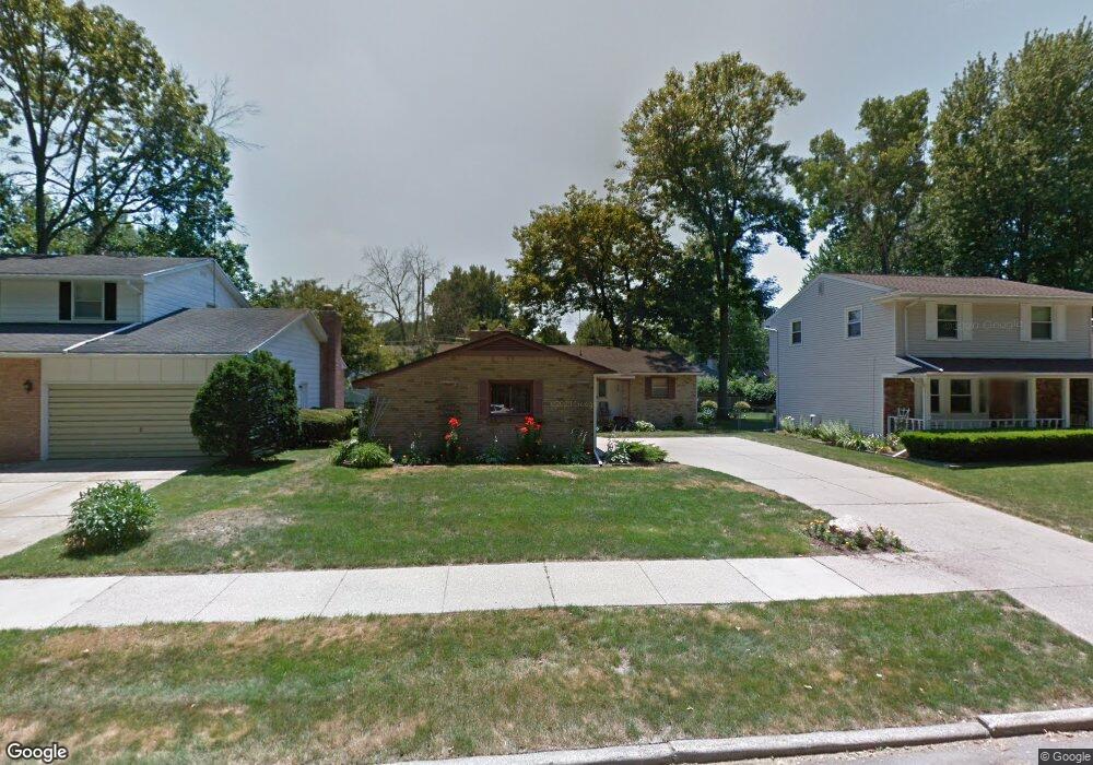
2013 Rock Way Lansing, MI 48910
Colonial Village NeighborhoodEstimated Value: $184,251 - $204,000
Studio
1
Bath
1,318
Sq Ft
$147/Sq Ft
Est. Value
About This Home
This home is located at 2013 Rock Way, Lansing, MI 48910 and is currently estimated at $193,313, approximately $146 per square foot. 2013 Rock Way is a home located in Ingham County with nearby schools including Averill Elementary School, Attwood School, and J.W. Sexton High School.
Ownership History
Date
Name
Owned For
Owner Type
Purchase Details
Closed on
Apr 23, 2004
Sold by
Estate Of Howard H Thompson
Bought by
Owens Taryn D
Current Estimated Value
Home Financials for this Owner
Home Financials are based on the most recent Mortgage that was taken out on this home.
Original Mortgage
$129,960
Outstanding Balance
$60,303
Interest Rate
5.46%
Mortgage Type
FHA
Estimated Equity
$133,010
Create a Home Valuation Report for This Property
The Home Valuation Report is an in-depth analysis detailing your home's value as well as a comparison with similar homes in the area
Home Values in the Area
Average Home Value in this Area
Purchase History
| Date | Buyer | Sale Price | Title Company |
|---|---|---|---|
| Owens Taryn D | $132,000 | -- |
Source: Public Records
Mortgage History
| Date | Status | Borrower | Loan Amount |
|---|---|---|---|
| Open | Owens Taryn D | $129,960 |
Source: Public Records
Tax History
| Year | Tax Paid | Tax Assessment Tax Assessment Total Assessment is a certain percentage of the fair market value that is determined by local assessors to be the total taxable value of land and additions on the property. | Land | Improvement |
|---|---|---|---|---|
| 2025 | $3,132 | $93,400 | $11,300 | $82,100 |
| 2024 | $25 | $79,600 | $11,300 | $68,300 |
| 2023 | $2,936 | $69,800 | $11,300 | $58,500 |
| 2022 | $2,647 | $66,100 | $9,800 | $56,300 |
| 2021 | $2,592 | $60,000 | $9,300 | $50,700 |
| 2020 | $2,576 | $58,700 | $9,300 | $49,400 |
| 2019 | $2,470 | $53,000 | $9,300 | $43,700 |
| 2018 | $2,314 | $47,600 | $9,300 | $38,300 |
| 2017 | $2,216 | $47,600 | $9,300 | $38,300 |
| 2016 | $2,119 | $41,600 | $9,300 | $32,300 |
| 2015 | $2,119 | $38,800 | $18,600 | $20,200 |
| 2014 | $2,119 | $37,600 | $12,000 | $25,600 |
Source: Public Records
Map
Nearby Homes
- 3125 Boston Blvd
- 1703 Holly Way
- 2711 Pleasant Grove Rd
- 1604 Peggy Place
- 1714 Loraine Ave
- 2505 Fairfax Rd
- 2408 Dunlap St
- 2409 Victor Ave
- 1817 Gordon Ave
- 0 Dunlap St
- 2105 Hampden Dr
- 2315 Belaire Dr
- 1414 Cooper Ave
- 3212 S Catherine St
- 1422 Warwick Dr
- 2418 Belaire Dr
- 924 Loa St
- 1033 Kelsey Ave
- 1125 Poxson Ave
- 0 S Deerfield Ave
- 2019 Rock Way
- 2007 Rock Way
- 2025 Rock Way
- 2003 Rock Way
- 3106 Boston Blvd
- 3100 Boston Blvd
- 3112 Boston Blvd
- 3046 Boston Blvd
- 3116 Boston Blvd
- 1933 Rock Way
- 2029 Rock Way
- 2014 Rock Way
- 2008 Rock Way
- 2020 Rock Way
- 2000 Rock Way
- 3040 Boston Blvd
- 3122 Boston Blvd
- 2024 Rock Way
- 1925 Rock Way
- 2035 Rock Way
Your Personal Tour Guide
Ask me questions while you tour the home.