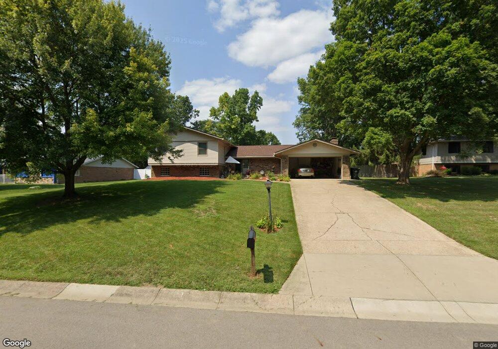
2017 Meadowside Ln Dayton, OH 45458
Estimated Value: $362,000 - $386,000
4
Beds
3
Baths
2,118
Sq Ft
$175/Sq Ft
Est. Value
About This Home
This home is located at 2017 Meadowside Ln, Dayton, OH 45458 and is currently estimated at $371,443, approximately $175 per square foot. 2017 Meadowside Ln is a home located in Montgomery County with nearby schools including Primary Village South, Cline Elementary, and Tower Heights Middle School.
Ownership History
Date
Name
Owned For
Owner Type
Purchase Details
Closed on
Sep 15, 2003
Sold by
Warren Anthony G and Warren Laura M
Bought by
Baniel Frank and Baniel Tonga Ann
Current Estimated Value
Home Financials for this Owner
Home Financials are based on the most recent Mortgage that was taken out on this home.
Original Mortgage
$178,965
Outstanding Balance
$82,134
Interest Rate
6.44%
Mortgage Type
Purchase Money Mortgage
Estimated Equity
$289,309
Purchase Details
Closed on
Jul 19, 2002
Sold by
Warren Anthony G
Bought by
Warren Laura M
Purchase Details
Closed on
Jan 4, 1994
Sold by
Mason Thomas R and Mason Kathy L
Bought by
Warren Anthony G and Warren Laura M
Create a Home Valuation Report for This Property
The Home Valuation Report is an in-depth analysis detailing your home's value as well as a comparison with similar homes in the area
Purchase History
| Date | Buyer | Sale Price | Title Company |
|---|---|---|---|
| Baniel Frank | $184,500 | -- | |
| Warren Laura M | -- | -- | |
| Warren Anthony G | -- | -- |
Source: Public Records
Mortgage History
| Date | Status | Borrower | Loan Amount |
|---|---|---|---|
| Open | Baniel Frank | $178,965 |
Source: Public Records
Tax History
| Year | Tax Paid | Tax Assessment Tax Assessment Total Assessment is a certain percentage of the fair market value that is determined by local assessors to be the total taxable value of land and additions on the property. | Land | Improvement |
|---|---|---|---|---|
| 2025 | $7,440 | $110,950 | $18,760 | $92,190 |
| 2024 | $6,836 | $110,950 | $18,760 | $92,190 |
| 2023 | $6,836 | $110,950 | $18,760 | $92,190 |
| 2022 | $6,450 | $82,810 | $14,000 | $68,810 |
| 2021 | $6,467 | $82,810 | $14,000 | $68,810 |
| 2020 | $6,458 | $82,810 | $14,000 | $68,810 |
| 2019 | $6,130 | $70,220 | $14,000 | $56,220 |
| 2018 | $5,475 | $70,220 | $14,000 | $56,220 |
| 2017 | $5,416 | $70,220 | $14,000 | $56,220 |
| 2016 | $4,939 | $60,330 | $14,000 | $46,330 |
| 2015 | $4,859 | $60,330 | $14,000 | $46,330 |
| 2014 | $4,859 | $60,330 | $14,000 | $46,330 |
| 2012 | -- | $65,590 | $14,000 | $51,590 |
Source: Public Records
Map
Nearby Homes
- 1921 Washington Creek Ln
- 2054 Washington Creek Ln
- 1800 Washington Creek Ln
- 9424 Clyo Rd
- 2439 Beechknoll Point
- 8661 Hide a Way Ln
- 9043 Academy View Ct
- 2550 Chess Wood Point
- 8470 Koster Ln
- 1864 Tossing Mane Ct
- 2551 Woodbluff Ln
- 1947 Horseshoe Bend
- 9428 Old Bridge Dr
- 8025 Station House Rd
- 2036 Buglers Sound
- 9555 Clyo Rd
- 1890 Horseshoe Bend
- 1886 Horseshoe Bend
- 2516 S Park Ln
- 9882 Saddle Creek Trail
- 2009 Meadowside Ln
- 2012 Washington Creek Ln
- 2006 Washington Creek Ln
- 2018 Washington Creek Ln
- 2016 Meadowside Ln
- 2020 Meadowside Ln
- 2003 Meadowside Ln
- 2012 Meadowside Ln
- 2024 Washington Creek Ln
- 2024 Meadowside Ln
- 2008 Meadowside Ln
- 2029 Meadowside Ln
- 2028 Meadowside Ln
- 2004 Meadowside Ln
- 8820 Sugarcreek Point
- 8928 Deep Forest Ln
- 2030 Washington Creek Ln
- 8932 Deep Forest Ln
- 8924 Deep Forest Ln
- 2001 Washington Creek Ln
Your Personal Tour Guide
Ask me questions while you tour the home.