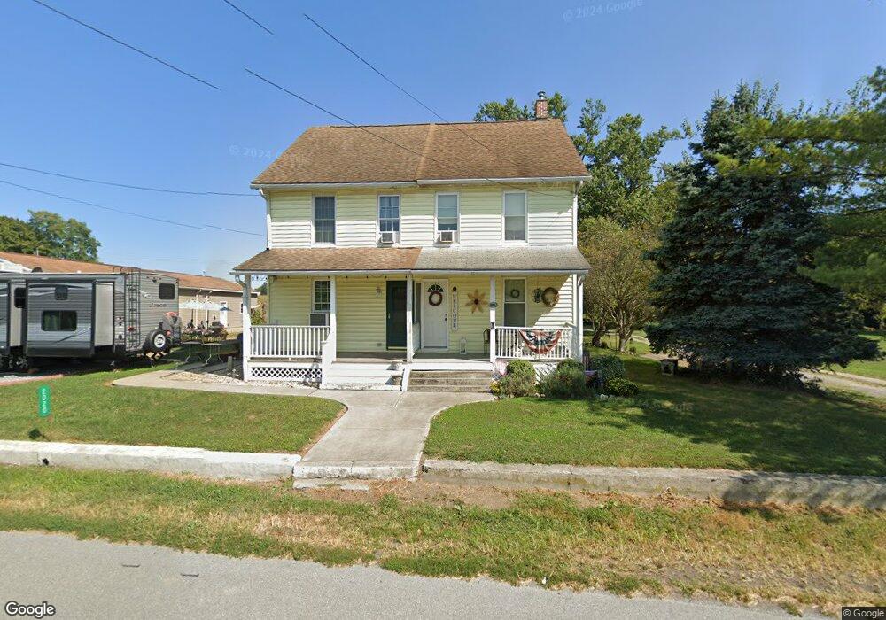
2018 River Rd Bainbridge, PA 17502
Estimated Value: $255,000 - $318,000
3
Beds
1
Bath
1,582
Sq Ft
$176/Sq Ft
Est. Value
About This Home
This home is located at 2018 River Rd, Bainbridge, PA 17502 and is currently estimated at $279,107, approximately $176 per square foot. 2018 River Rd is a home located in Lancaster County with nearby schools including Bainbridge Elementary School, Elizabethtown Area Middle School, and Elizabethtown Area Senior High School.
Ownership History
Date
Name
Owned For
Owner Type
Purchase Details
Closed on
Nov 20, 2002
Sold by
Mchenry Sharon R and Mchenry James K
Bought by
Mchenry Sharon R
Current Estimated Value
Home Financials for this Owner
Home Financials are based on the most recent Mortgage that was taken out on this home.
Original Mortgage
$50,000
Interest Rate
5.95%
Purchase Details
Closed on
Apr 22, 1996
Bought by
Mchenry Sharon R
Create a Home Valuation Report for This Property
The Home Valuation Report is an in-depth analysis detailing your home's value as well as a comparison with similar homes in the area
Home Values in the Area
Average Home Value in this Area
Purchase History
| Date | Buyer | Sale Price | Title Company |
|---|---|---|---|
| Mchenry Sharon R | -- | -- | |
| Mchenry Sharon R | -- | -- |
Source: Public Records
Mortgage History
| Date | Status | Borrower | Loan Amount |
|---|---|---|---|
| Closed | Mchenry Sharon R | $50,000 |
Source: Public Records
Tax History
| Year | Tax Paid | Tax Assessment Tax Assessment Total Assessment is a certain percentage of the fair market value that is determined by local assessors to be the total taxable value of land and additions on the property. | Land | Improvement |
|---|---|---|---|---|
| 2025 | $3,220 | $142,600 | $48,300 | $94,300 |
| 2024 | $3,220 | $142,600 | $48,300 | $94,300 |
| 2023 | $3,069 | $142,600 | $48,300 | $94,300 |
| 2022 | $2,991 | $142,600 | $48,300 | $94,300 |
| 2021 | $2,852 | $142,600 | $48,300 | $94,300 |
| 2020 | $2,852 | $142,600 | $48,300 | $94,300 |
| 2019 | $2,783 | $142,600 | $48,300 | $94,300 |
| 2018 | $3,388 | $142,600 | $48,300 | $94,300 |
| 2017 | $2,300 | $97,300 | $27,200 | $70,100 |
| 2016 | $2,300 | $97,300 | $27,200 | $70,100 |
| 2015 | $363 | $97,300 | $27,200 | $70,100 |
| 2014 | $1,787 | $97,300 | $27,200 | $70,100 |
Source: Public Records
Map
Nearby Homes
- 290 Locust Grove Rd
- 435 N Burberry Ln
- 55 Burberry Ln
- 140 Burberry Ln
- 254 Walnut St
- 289 Buttonwood Dr
- 1762 Stonemill Dr
- 737 Lake Dr
- 15 Catalina Dr
- 723 Lake Dr
- 304 Landola Ave
- 209 Holly Dr
- 115 Austin Dr
- 117 S 8th St
- 143 N 2nd St
- 380 Ridgefield Dr
- 220 Pebble Dr
- 135 Torrey Pines Dr
- 126 N West View Dr
- 102 104 S Third St
- 2020 River Rd
- 2024 River Rd
- 2014 River Rd
- 2026 River Rd
- 2030 River Rd
- 2032 River Rd
- 2036 River Rd
- 2038 River Rd
- 2042 River Rd
- 2044 River Rd
- 2044 River Rd
- 192 Wickersham Rd
- 188 Wickersham Rd
- 2037 River Rd
- 184 Wickersham Rd
- 184 Wickersham Rd
- 1935 River Rd
- 180 Wickersham Rd
- 178 Wickersham Rd
- 156 Wickersham Rd
Your Personal Tour Guide
Ask me questions while you tour the home.