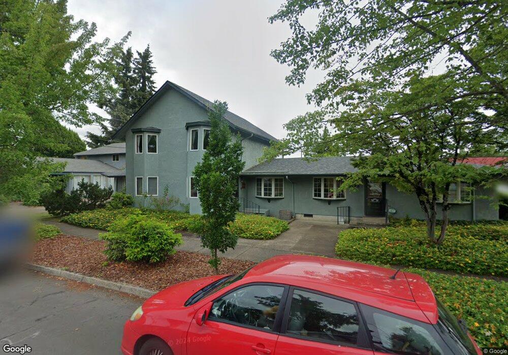
2025 W 12th Ave Eugene, OR 97402
Far West NeighborhoodEstimated Value: $568,437
Studio
--
Bath
6,000
Sq Ft
$95/Sq Ft
Est. Value
About This Home
This home is located at 2025 W 12th Ave, Eugene, OR 97402 and is currently estimated at $568,437, approximately $94 per square foot. 2025 W 12th Ave is a home located in Lane County with nearby schools including Cesar Chavez Elementary School, Arts And Technology Academy At Jefferson, and Churchill High School.
Ownership History
Date
Name
Owned For
Owner Type
Purchase Details
Closed on
Jun 27, 2024
Sold by
Blair Beatrice B
Bought by
Rking Llc
Current Estimated Value
Purchase Details
Closed on
Aug 27, 2021
Sold by
Kirkpatrick Kit D
Bought by
Blair Beatrice B
Home Financials for this Owner
Home Financials are based on the most recent Mortgage that was taken out on this home.
Original Mortgage
$393,750
Outstanding Balance
$242,477
Interest Rate
2.7%
Mortgage Type
Commercial
Estimated Equity
$325,960
Purchase Details
Closed on
May 29, 2002
Sold by
Mohler Jerry C
Bought by
Kirkpatrick Kit D
Create a Home Valuation Report for This Property
The Home Valuation Report is an in-depth analysis detailing your home's value as well as a comparison with similar homes in the area
Home Values in the Area
Average Home Value in this Area
Purchase History
| Date | Buyer | Sale Price | Title Company |
|---|---|---|---|
| Rking Llc | $479,891 | None Listed On Document | |
| Blair Beatrice B | $525,000 | Cascade Title Co | |
| Kirkpatrick Kit D | $470,000 | Western Pioneer Title Co |
Source: Public Records
Mortgage History
| Date | Status | Borrower | Loan Amount |
|---|---|---|---|
| Open | Blair Beatrice B | $393,750 |
Source: Public Records
Tax History
| Year | Tax Paid | Tax Assessment Tax Assessment Total Assessment is a certain percentage of the fair market value that is determined by local assessors to be the total taxable value of land and additions on the property. | Land | Improvement |
|---|---|---|---|---|
| 2025 | $6,886 | $353,400 | -- | -- |
| 2024 | $6,800 | $343,107 | -- | -- |
| 2023 | $6,800 | $333,114 | $0 | $0 |
| 2022 | $6,370 | $323,412 | $0 | $0 |
| 2021 | $5,974 | $313,516 | $0 | $0 |
| 2020 | $5,995 | $304,385 | $0 | $0 |
| 2019 | $5,790 | $295,520 | $0 | $0 |
| 2018 | $5,407 | $278,556 | $0 | $0 |
| 2017 | $5,126 | $278,556 | $0 | $0 |
| 2016 | $4,915 | $270,443 | $0 | $0 |
| 2015 | $4,820 | $262,566 | $0 | $0 |
| 2014 | $4,774 | $254,918 | $0 | $0 |
Source: Public Records
Map
Nearby Homes
- 1243 Hayes St
- 2132 W 14th Ct
- 0 W 15th Ave Unit Lot B
- 1875 W 15th Ave
- 1579 Garfield Place Unit 1579
- 2161 W 16th Ave
- 2330 W 14th Ave
- 1935 W 17th Ave Unit B
- 1933 W 17th Ave Unit B
- 1509 Mckinley St
- 2070 W 16th Way
- 2064 W 17th Ave
- 1735 Cleveland Place
- 1445 W 11th Ave
- 1255 Taylor St
- 1362 W 11th Ave
- 1488 Fetters Loop
- 1130 Polk St
- 1955 Arthur St
- 2125 W 19th Place
- 2045 W 12th Ave
- 2050 W 12th Ave
- 2075 W 12th Ave
- 1210 1212 Garfield St
- 1210-1212 Garfield St
- 1210 Garfield (-1212) St
- 1210 Garfield St
- 2060 W 12th Ave
- 1212 Garfield St
- 2080 W 12th Ave
- 1165 Garfield St
- 1242 Garfield St
- 1215 Arthur St
- 1990 W 12th Ave
- 1985 W 12th Ave
- 1250 Garfield St
- 1980 W 12th Ave
- 1980 W 12th Ave
- 1955 W 12th Ave
- 1981 W 12th Aly
Your Personal Tour Guide
Ask me questions while you tour the home.