Estimated Value: $408,000 - $525,000
4
Beds
2
Baths
1,946
Sq Ft
$243/Sq Ft
Est. Value
About This Home
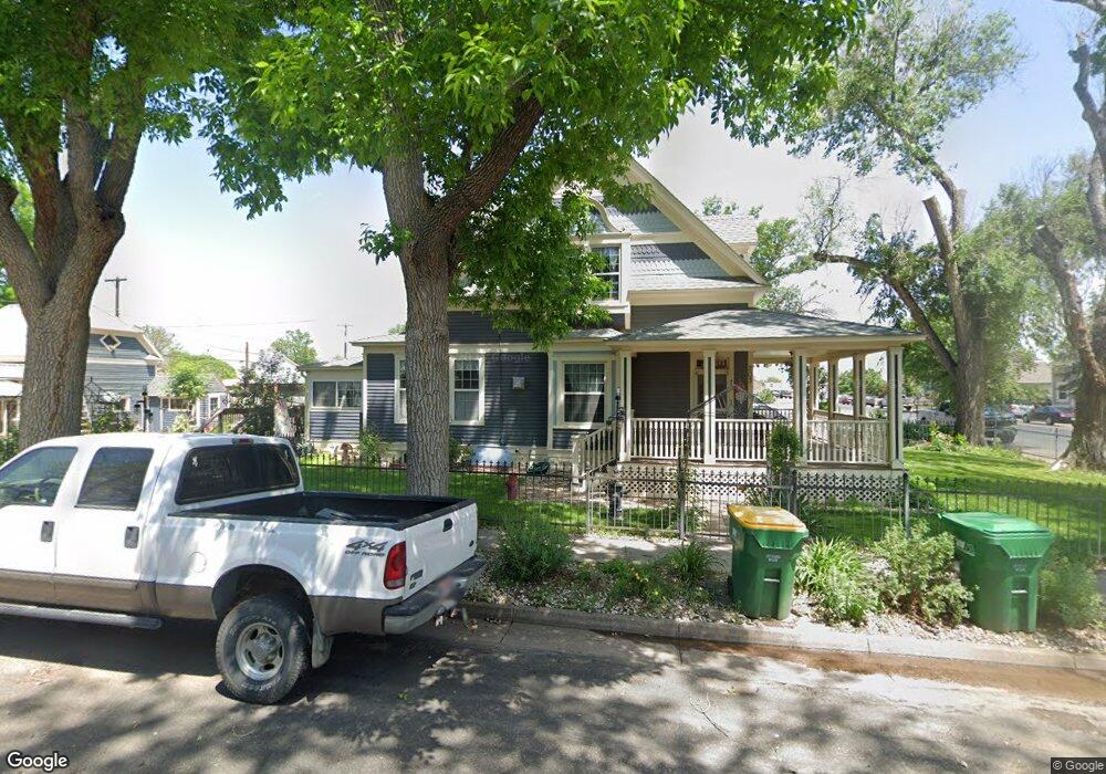
This home is located at 203 B St, Ault, CO 80610 and is currently estimated at $473,667, approximately $243 per square foot. 203 B St is a home with nearby schools including Highland Elementary School, Highland Middle School, and Highland High School.
Ownership History
Date
Name
Owned For
Owner Type
Purchase Details
Closed on
Nov 26, 2004
Sold by
White Mark K and White Eileen Kay
Bought by
White Mark K
Current Estimated Value
Home Financials for this Owner
Home Financials are based on the most recent Mortgage that was taken out on this home.
Original Mortgage
$168,000
Outstanding Balance
$84,415
Interest Rate
5.78%
Mortgage Type
Stand Alone Refi Refinance Of Original Loan
Estimated Equity
$389,252
Purchase Details
Closed on
Aug 18, 2000
Sold by
Dickerson Allen C and Dickerson Anne Elizabeth
Bought by
White Mark K and White Eileen Kay
Home Financials for this Owner
Home Financials are based on the most recent Mortgage that was taken out on this home.
Original Mortgage
$112,100
Interest Rate
8.15%
Create a Home Valuation Report for This Property
The Home Valuation Report is an in-depth analysis detailing your home's value as well as a comparison with similar homes in the area
Purchase History
| Date | Buyer | Sale Price | Title Company |
|---|---|---|---|
| White Mark K | -- | Land Title Guarantee Company | |
| White Mark K | $118,000 | -- |
Source: Public Records
Mortgage History
| Date | Status | Borrower | Loan Amount |
|---|---|---|---|
| Open | White Mark K | $168,000 | |
| Closed | White Mark K | $112,100 | |
| Closed | White Mark K | $31,500 |
Source: Public Records
Tax History
| Year | Tax Paid | Tax Assessment Tax Assessment Total Assessment is a certain percentage of the fair market value that is determined by local assessors to be the total taxable value of land and additions on the property. | Land | Improvement |
|---|---|---|---|---|
| 2025 | $1,573 | $23,020 | $3,630 | $19,390 |
| 2024 | $1,573 | $23,020 | $3,630 | $19,390 |
| 2023 | $1,280 | $25,300 | $3,790 | $21,510 |
| 2022 | $1,262 | $20,190 | $2,910 | $17,280 |
| 2021 | $1,328 | $20,760 | $2,990 | $17,770 |
| 2020 | $1,208 | $18,950 | $1,900 | $17,050 |
| 2019 | $1,274 | $18,950 | $1,900 | $17,050 |
| 2018 | $1,138 | $16,670 | $1,660 | $15,010 |
| 2017 | $1,140 | $16,670 | $1,660 | $15,010 |
| 2016 | $1,057 | $15,780 | $1,280 | $14,500 |
| 2015 | $1,061 | $15,780 | $1,280 | $14,500 |
| 2014 | $464 | $6,920 | $1,510 | $5,410 |
Source: Public Records
Map
Nearby Homes
- 226 1st St
- 304 S 1st Ave
- 112 2nd St
- 106 Linden Oaks Dr
- 301 E 1st St
- 211 Linden Oaks Dr
- 16627 Highway 14 Unit 3
- 710 Oregon Trail Unit C4
- 710 Oregon Trail Unit D3
- 390 Cherokee Trail
- 294 Gila Trail
- 639 Woods Ave
- 640 Cimarron Trail
- 374 Pony Express Trail
- 441 Gila Trail
- 603 Apex Trail
- 0 County Road 37
- 1220 Swainson Rd
- 1230 Swainson Rd
- 0 County Road 86 Unit IRE1051337
Your Personal Tour Guide
Ask me questions while you tour the home.