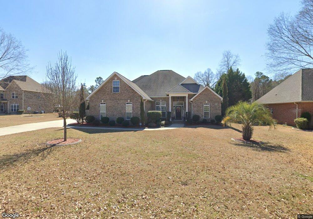
203 Lowpoint Trail Warner Robins, GA 31093
Estimated Value: $485,000 - $595,000
4
Beds
3
Baths
3,132
Sq Ft
$167/Sq Ft
Est. Value
About This Home
This home is located at 203 Lowpoint Trail, Warner Robins, GA 31093 and is currently estimated at $521,888, approximately $166 per square foot. 203 Lowpoint Trail is a home located in Houston County with nearby schools including Northside Elementary School, Thomson Middle School, and Northside High School.
Ownership History
Date
Name
Owned For
Owner Type
Purchase Details
Closed on
Jun 25, 2010
Sold by
C & Rw Homebuilders Inc
Bought by
Livingston Mark L and Livingston Tamika L
Current Estimated Value
Home Financials for this Owner
Home Financials are based on the most recent Mortgage that was taken out on this home.
Original Mortgage
$297,900
Outstanding Balance
$195,191
Interest Rate
4.91%
Mortgage Type
VA
Estimated Equity
$326,697
Purchase Details
Closed on
Feb 16, 2007
Sold by
Newton Development Llc
Bought by
C&Rw Homebuilders Inc
Create a Home Valuation Report for This Property
The Home Valuation Report is an in-depth analysis detailing your home's value as well as a comparison with similar homes in the area
Home Values in the Area
Average Home Value in this Area
Purchase History
| Date | Buyer | Sale Price | Title Company |
|---|---|---|---|
| Livingston Mark L | $297,900 | None Available | |
| C&Rw Homebuilders Inc | $46,000 | -- |
Source: Public Records
Mortgage History
| Date | Status | Borrower | Loan Amount |
|---|---|---|---|
| Open | Livingston Mark L | $297,900 |
Source: Public Records
Tax History
| Year | Tax Paid | Tax Assessment Tax Assessment Total Assessment is a certain percentage of the fair market value that is determined by local assessors to be the total taxable value of land and additions on the property. | Land | Improvement |
|---|---|---|---|---|
| 2025 | $1,536 | $192,120 | $17,000 | $175,120 |
| 2024 | $1,851 | $194,400 | $17,000 | $177,400 |
| 2023 | $1,299 | $163,720 | $17,000 | $146,720 |
| 2022 | $793 | $134,560 | $17,000 | $117,560 |
| 2021 | $2,908 | $119,680 | $17,000 | $102,680 |
| 2020 | $2,895 | $118,600 | $17,000 | $101,600 |
| 2019 | $2,895 | $118,600 | $17,000 | $101,600 |
| 2018 | $2,895 | $118,600 | $17,000 | $101,600 |
| 2017 | $2,898 | $118,600 | $17,000 | $101,600 |
| 2016 | $2,902 | $118,600 | $17,000 | $101,600 |
| 2015 | $2,908 | $118,600 | $17,000 | $101,600 |
| 2014 | -- | $115,080 | $17,000 | $98,080 |
| 2013 | -- | $115,080 | $17,000 | $98,080 |
Source: Public Records
Map
Nearby Homes
- 324 Air View Dr Unit 13
- 308 Air View Dr Unit 5
- 308 Air View Dr
- 322 Air View Dr Unit 12
- 312 Air View Dr Unit 7
- 310 Air View Dr Unit 6
- 304 Air View Dr Unit 3
- 304 Air View Dr
- 312 Air View Dr
- 310 Air View Dr
- 105 Majestic Trail
- 116 Majestic Trail
- 103 Brookshire Way
- 106 John Ct
- 4001 U S 41 Unit LOT 65
- 223 River Birch Way
- 99 Bermuda Dr
- 214 Coastal Dr
- 211 Coastal Dr
- 141 Back Cedar Ln
- 205 Lowpoint Trail
- 201 Lowpoint Trail
- 202 Lowpoint Trail
- 207 Lowpoint Trail
- 200 Lowpoint Trail Unit 36496638
- 200 Lowpoint Trail Unit 36438395
- 200 Lowpoint Trail Unit 36482599
- 200 Lowpoint Trail Unit 36477360
- 200 Lowpoint Trail Unit 36450886
- 200 Lowpoint Trail Unit 36501557
- 200 Lowpoint Trail
- 204 Lowpoint Trail
- 209 Lowpoint Trail
- 206 Lowpoint Trail
- 208 Lowpoint Trail
- 501 Mountain Trail
- 211 Lowpoint Trail
- 120 Lookout Trail
- 503 Mountain Trail
- 505 Mountain Trail
Your Personal Tour Guide
Ask me questions while you tour the home.