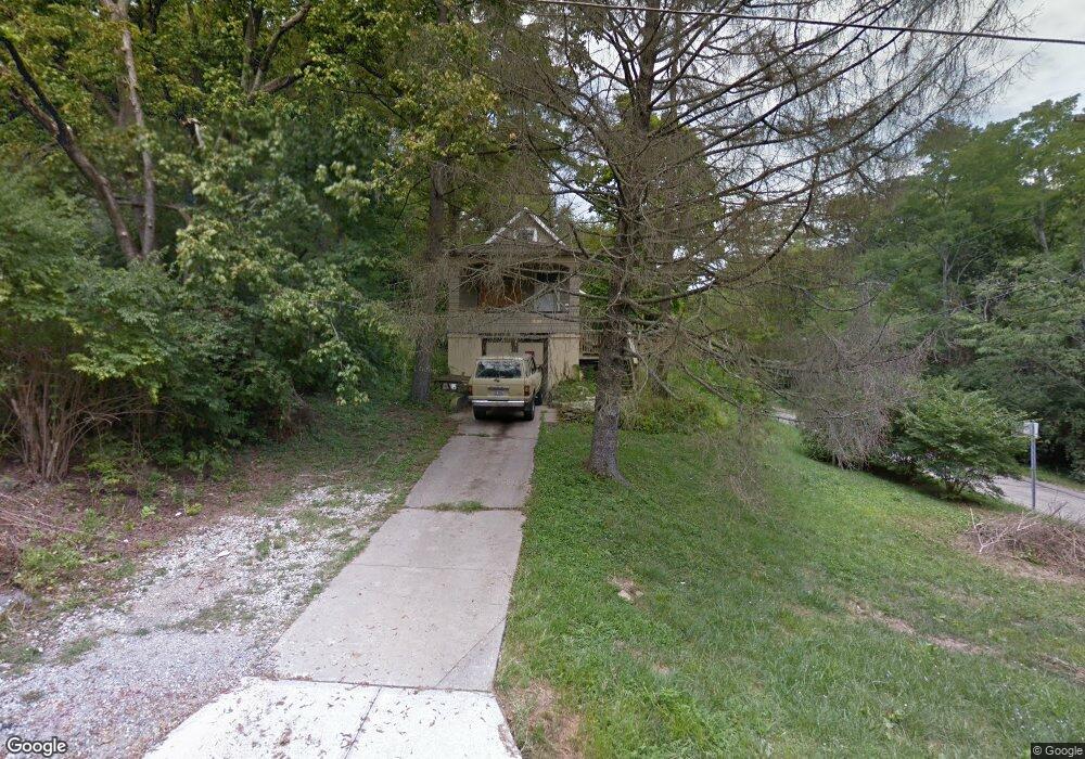
2032 Yoast Ave Cincinnati, OH 45225
East Westwood NeighborhoodEstimated Value: $79,848 - $170,000
About This Home
This home is located at 2032 Yoast Ave, Cincinnati, OH 45225 and is currently estimated at $111,962, approximately $89 per square foot. 2032 Yoast Ave is a home located in Hamilton County with nearby schools including Western Hills High School, Gilbert A. Dater High School, and Robert A. Taft Information Technology High School.
Ownership History
We collect this data history from publicly available records. To have your information removed, we recommend requesting removal directly through your county’s website.
Purchase Details
Purchase Details
Purchase Details
Home Financials for this Owner
Home Financials are based on the most recent Mortgage that was taken out on this home.Purchase Details
Home Financials for this Owner
Home Financials are based on the most recent Mortgage that was taken out on this home.Purchase Details
Home Financials for this Owner
Home Financials are based on the most recent Mortgage that was taken out on this home.Purchase Details
Home Values in the Area
Average Home Value in this Area
Purchase History
We collect this data history from publicly available records. To have your information removed, we recommend requesting removal directly through your county’s website.
| Date | Buyer | Sale Price | Title Company |
|---|---|---|---|
| $1,000 | Classic Title Agency Llc | ||
| $14,000 | None Available | ||
| $75,000 | First Service Title Agency I | ||
| $29,000 | -- | ||
| $29,000 | -- | ||
| -- | -- |
Mortgage History
We collect this data history from publicly available records. To have your information removed, we recommend requesting removal directly through your county’s website.
| Date | Status | Borrower | Loan Amount |
|---|---|---|---|
| Previous Owner | $67,500 | ||
| Previous Owner | $26,100 |
Tax History
We collect this data history from publicly available records. To have your information removed, we recommend requesting removal directly through your county’s website.
| Year | Tax Paid | Tax Assessment Tax Assessment Total Assessment is a certain percentage of the fair market value that is determined by local assessors to be the total taxable value of land and additions on the property. | Land | Improvement |
|---|---|---|---|---|
| 2025 | $864 | $11,215 | $1,523 | $9,692 |
| 2024 | $863 | $11,215 | $1,523 | $9,692 |
| 2023 | $864 | $11,215 | $1,523 | $9,692 |
| 2022 | $423 | $3,819 | $1,054 | $2,765 |
| 2021 | $310 | $3,819 | $1,054 | $2,765 |
| 2020 | $310 | $3,819 | $1,054 | $2,765 |
| 2019 | $464 | $5,495 | $1,022 | $4,473 |
| 2018 | $464 | $5,495 | $1,022 | $4,473 |
| 2017 | $445 | $5,495 | $1,022 | $4,473 |
| 2016 | $394 | $4,691 | $1,887 | $2,804 |
| 2015 | $357 | $4,691 | $1,887 | $2,804 |
| 2014 | $359 | $4,691 | $1,887 | $2,804 |
| 2013 | $521 | $7,001 | $2,818 | $4,183 |
Map
- 2041 Baltimore Ave
- 2006 Baltimore Ave
- 2167 Westwood Northern Blvd
- 2183 Westwood Northern Blvd
- 3384 Ninann Ct
- 1959 Baltimore Ave
- 1970 Westwood Northern Blvd
- 1767 Sutter Ave
- 2043 E Teralta Cir
- 2088 N Teralta Cir
- 3295 Fyffe Ave
- 1883 Baltimore Ave
- 2114 Saint Leo Place
- 3319 Cavanaugh Ave
- 3312 Mchenry Ave
- 3555 Mchenry Ave
- 2843 Robert Ave
- 3521 Mchenry Ave
- 3065 Aquadale Ln
- 3519 Mchenry Ave
- 2036 Yoast Ave
- 2077 Harkness St
- 2040 Yoast Ave
- 2095 Yoast Ave
- 2047 Harkness St
- 2080 Harkness St
- 2079 Harkness St
- 2041 Yoast Ave
- 2048 Yoast Ave
- 2039 Yoast Ave
- 2079 Baltimore Ave
- 2081 Harkness St
- 2045 Harkness St
- 2081 Baltimore Ave
- 2049 Yoast Ave
- 2054 Yoast Ave
- 2042 Harkness St
- 2082 Harkness St
- 2078 Baltimore Ave
- 2058 Yoast Ave
Ask me questions while you tour the home.