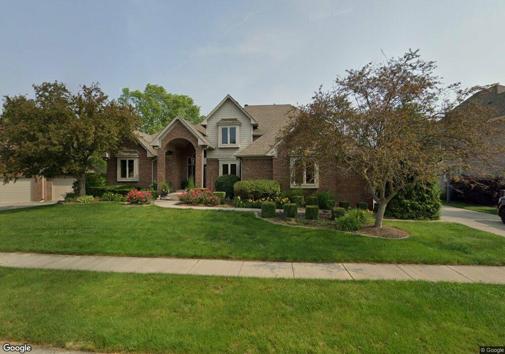
2040 Saint Andrews Ct Franklin, IN 46131
Estimated Value: $548,760 - $753,000
About This Home
This home is located at 2040 Saint Andrews Ct, Franklin, IN 46131 and is currently estimated at $643,440, approximately $230 per square foot. 2040 Saint Andrews Ct is a home located in Johnson County with nearby schools including Needham Elementary School, Franklin Community Middle School, and Custer Baker Intermediate School.
Ownership History
We collect this data history from publicly available records. To have your information removed, we recommend requesting removal directly through your county’s website.
Purchase Details
Home Financials for this Owner
Home Financials are based on the most recent Mortgage that was taken out on this home.Home Values in the Area
Average Home Value in this Area
Purchase History
We collect this data history from publicly available records. To have your information removed, we recommend requesting removal directly through your county’s website.
| Date | Buyer | Sale Price | Title Company |
|---|---|---|---|
| -- | Chicago Title Company Llc |
Mortgage History
We collect this data history from publicly available records. To have your information removed, we recommend requesting removal directly through your county’s website.
| Date | Status | Borrower | Loan Amount |
|---|---|---|---|
| Open | $334,800 |
Tax History
We collect this data history from publicly available records. To have your information removed, we recommend requesting removal directly through your county’s website.
| Year | Tax Paid | Tax Assessment Tax Assessment Total Assessment is a certain percentage of the fair market value that is determined by local assessors to be the total taxable value of land and additions on the property. | Land | Improvement |
|---|---|---|---|---|
| 2025 | $5,380 | $502,300 | $44,500 | $457,800 |
| 2024 | $5,443 | $486,200 | $44,500 | $441,700 |
| 2023 | $5,374 | $479,100 | $44,500 | $434,600 |
| 2022 | $5,147 | $454,200 | $41,900 | $412,300 |
| 2021 | $4,278 | $378,600 | $41,900 | $336,700 |
| 2020 | $3,732 | $331,100 | $41,900 | $289,200 |
| 2019 | $3,769 | $334,300 | $41,900 | $292,400 |
| 2018 | $3,240 | $332,800 | $41,900 | $290,900 |
| 2017 | $3,140 | $312,700 | $41,900 | $270,800 |
| 2016 | $3,108 | $301,900 | $41,900 | $260,000 |
| 2014 | $2,973 | $297,300 | $53,300 | $244,000 |
| 2013 | $2,973 | $266,800 | $53,300 | $213,500 |
Map
- 2144 Connie Ct
- 1159 Paris Dr
- 1895 Longest Dr
- 1440 Paris Dr
- 1682 Millpond Ln
- 1636 Millpond Ln
- 1679 Millpond Ln
- 1640 Millpond Ln
- 1650 Millpond Ln
- 1653 Millpond Ln
- 1630 Millpond Ln
- 1658 Millpond Ln
- 1627 Millpond Ln
- 1634 Millpond Ln
- 1672 Millpond Ln
- 1680 Millpond Ln
- 1676 Millpond Ln
- 361 Reagan Cir
- 100 Decourcy Ln
- 353 Carriage Ln
- 2020 Saint Andrews Ct
- 2060 Saint Andrews Ct
- 2080 Saint Andrews Ct
- 2055 Saint Andrews Ct
- 2075 Saint Andrews Ct
- 2005 Saint Andrews Ct
- 2035 Saint Andrews Ct
- 2015 Saint Andrews Ct
- 430 Saint Andrews Dr
- 430 St Andrews Dr
- 2090 Saint Andrews Ct
- 565 Augusta Ct
- 525 Augusta Ct
- 420 Saint Andrews Dr
- 510 Paris Dr
- 2070 Fairway Lakes Dr
- 530 Paris Dr
- 2060 Fairway Lakes Dr
- 445 Saint Andrews Dr
- 485 Augusta Ct
Ask me questions while you tour the home.