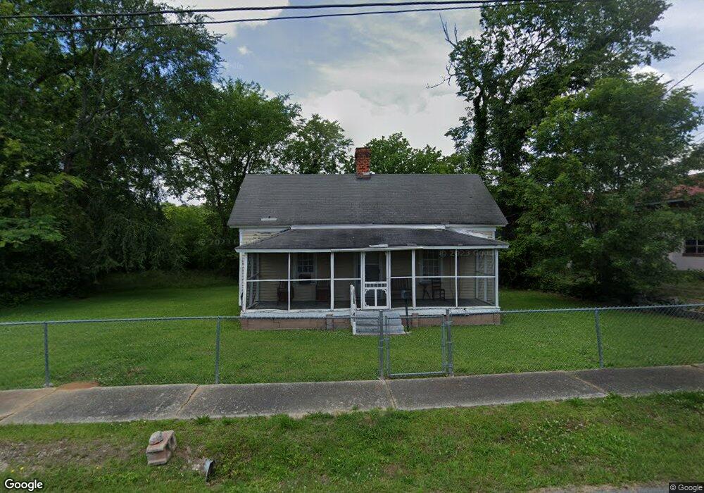
205 Binns St Union Point, GA 30669
Estimated Value: $68,014 - $147,000
1
Bed
1
Bath
778
Sq Ft
$128/Sq Ft
Est. Value
About This Home
This home is located at 205 Binns St, Union Point, GA 30669 and is currently estimated at $99,504, approximately $127 per square foot. 205 Binns St is a home located in Greene County with nearby schools including Greene County High School.
Ownership History
Date
Name
Owned For
Owner Type
Purchase Details
Closed on
Apr 30, 2006
Sold by
Brown Martha L
Bought by
Brown Martha L and Brown Linda
Current Estimated Value
Purchase Details
Closed on
Nov 18, 1991
Sold by
Hall Randy and Hall Judy
Bought by
Brown Martha
Purchase Details
Closed on
Jan 1, 1983
Sold by
Thomas Ollie C Mrs
Bought by
Hall Randy and Hall Judy
Purchase Details
Closed on
Jan 1, 1979
Sold by
Canup Johnny and Canup Judy M
Bought by
Thomas Ollie C Mrs
Purchase Details
Closed on
Jan 1, 1976
Sold by
Moon Billy
Bought by
Canup Johnny and Canup Judy M
Purchase Details
Closed on
Jan 1, 1966
Bought by
Moon Billy
Create a Home Valuation Report for This Property
The Home Valuation Report is an in-depth analysis detailing your home's value as well as a comparison with similar homes in the area
Purchase History
| Date | Buyer | Sale Price | Title Company |
|---|---|---|---|
| Brown Martha L | -- | -- | |
| Brown Martha | $15,500 | -- | |
| Hall Randy | -- | -- | |
| Thomas Ollie C Mrs | -- | -- | |
| Canup Johnny | -- | -- | |
| Moon Billy | -- | -- |
Source: Public Records
Tax History
| Year | Tax Paid | Tax Assessment Tax Assessment Total Assessment is a certain percentage of the fair market value that is determined by local assessors to be the total taxable value of land and additions on the property. | Land | Improvement |
|---|---|---|---|---|
| 2025 | $610 | $16,200 | $2,440 | $13,760 |
| 2024 | $581 | $15,200 | $2,440 | $12,760 |
| 2023 | $245 | $14,680 | $2,440 | $12,240 |
| 2022 | $289 | $13,760 | $2,440 | $11,320 |
| 2021 | $288 | $12,560 | $2,440 | $10,120 |
| 2020 | $260 | $6,640 | $2,680 | $3,960 |
| 2019 | $263 | $6,640 | $2,680 | $3,960 |
| 2018 | $124 | $6,640 | $2,680 | $3,960 |
| 2017 | $233 | $6,700 | $2,700 | $4,000 |
| 2016 | $239 | $6,882 | $2,700 | $4,182 |
| 2015 | $211 | $6,881 | $2,700 | $4,182 |
| 2014 | $212 | $6,840 | $2,700 | $4,140 |
Source: Public Records
Map
Nearby Homes
- 509 Carlton Ave
- 93 Carlton Ave
- 1241 Old Siloam Rd
- 405 Crawfordville Rd
- 324 N Rhodes St
- 0 Woodland Ct Unit 10543600
- 215 Hunter St
- 1071 Alexander St
- 0 Washington Hwy Unit 10686255
- 000 Washington Hwy
- 1581 Highway 77 S Hwy
- 1581 Highway 77 S
- 5401 Union Point Hwy
- 1201 Buffalo Lick Rd
- 0 Buffalo Lick Rd Unit 10551234
- 0 Buffalo Lick Rd Unit 10551325
- 1251 Brick House Rd
- 1251 Brickhouse Rd
- 1251 Adams Rd
- 1681 Sibley School Rd
Your Personal Tour Guide
Ask me questions while you tour the home.