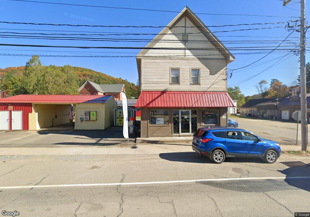
205 S Main St Sheffield, PA 16347
Estimated Value: $178,969
Studio
--
Bath
2,880
Sq Ft
$62/Sq Ft
Est. Value
About This Home
This home is located at 205 S Main St, Sheffield, PA 16347 and is currently estimated at $178,969, approximately $62 per square foot. 205 S Main St is a home located in Warren County with nearby schools including Sheffield Middle/High School.
Ownership History
Date
Name
Owned For
Owner Type
Purchase Details
Closed on
Jul 26, 2024
Sold by
Cajec Real Estate Llc
Bought by
Sheffield Suds All Llc
Current Estimated Value
Home Financials for this Owner
Home Financials are based on the most recent Mortgage that was taken out on this home.
Original Mortgage
$150,000
Outstanding Balance
$147,788
Interest Rate
6.95%
Mortgage Type
Credit Line Revolving
Estimated Equity
$31,181
Purchase Details
Closed on
May 17, 2022
Sold by
Votano Michael C
Bought by
Cajec Llc
Purchase Details
Closed on
Aug 13, 2021
Sold by
Drake Darren A and Drake Karla K
Bought by
Votano Michael C
Home Financials for this Owner
Home Financials are based on the most recent Mortgage that was taken out on this home.
Original Mortgage
$112,000
Interest Rate
2.15%
Mortgage Type
Construction
Create a Home Valuation Report for This Property
The Home Valuation Report is an in-depth analysis detailing your home's value as well as a comparison with similar homes in the area
Purchase History
| Date | Buyer | Sale Price | Title Company |
|---|---|---|---|
| Sheffield Suds All Llc | $229,000 | None Listed On Document | |
| Cajec Llc | $155,000 | -- | |
| Votano Michael C | $140,000 | -- |
Source: Public Records
Mortgage History
| Date | Status | Borrower | Loan Amount |
|---|---|---|---|
| Open | Sheffield Suds All Llc | $150,000 | |
| Closed | Sheffield Suds All Llc | $40,000 | |
| Previous Owner | Votano Michael C | $112,000 |
Source: Public Records
Tax History
| Year | Tax Paid | Tax Assessment Tax Assessment Total Assessment is a certain percentage of the fair market value that is determined by local assessors to be the total taxable value of land and additions on the property. | Land | Improvement |
|---|---|---|---|---|
| 2025 | $2,821 | $28,800 | $4,180 | $24,620 |
| 2024 | $2,823 | $28,800 | $4,180 | $24,620 |
| 2023 | $2,694 | $28,800 | $4,180 | $24,620 |
| 2022 | $2,559 | $28,800 | $4,180 | $24,620 |
| 2021 | $2,544 | $28,800 | $4,180 | $24,620 |
| 2020 | $2,535 | $28,800 | $4,180 | $24,620 |
| 2019 | $2,443 | $28,800 | $4,180 | $24,620 |
| 2018 | $2,508 | $28,800 | $4,180 | $24,620 |
| 2017 | $2,368 | $28,800 | $4,180 | $24,620 |
| 2016 | $2,397 | $28,800 | $0 | $0 |
| 2015 | -- | $28,800 | $0 | $0 |
| 2014 | -- | $28,800 | $0 | $0 |
| 2013 | -- | $28,800 | $4,180 | $24,620 |
Source: Public Records
Map
Nearby Homes
- 00 Austin Hill Rd
- 107 Crary Ave
- 0 Cottage Ave
- 109 Pickering St
- 16 Pickering St
- 224 Church St
- 60 2nd Mill St
- 92 3rd Mill St
- 6160 Route 666
- 10379 Route 6
- 21 Acton Place
- 6249 Cherry Grove Rd
- 69 Railroad St
- 6 Railroad St
- 261 Fork Run Rd
- 0 Johnson Rd
- 3 Belmont Dr
- 27 Warren Blvd
- 322 Park Ave
- 6 Leslie Blvd
Your Personal Tour Guide
Ask me questions while you tour the home.