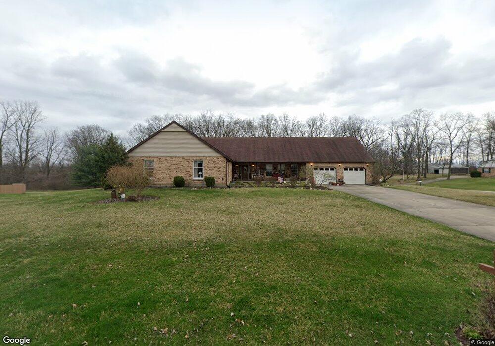
2058 Sundance St Springfield, OH 45502
Estimated Value: $401,000 - $465,000
3
Beds
4
Baths
2,832
Sq Ft
$151/Sq Ft
Est. Value
About This Home
This home is located at 2058 Sundance St, Springfield, OH 45502 and is currently estimated at $427,706, approximately $151 per square foot. 2058 Sundance St is a home located in Clark County with nearby schools including Greenon Elementary School, Greenon Jr. High School, and Greenon High School.
Ownership History
Date
Name
Owned For
Owner Type
Purchase Details
Closed on
Apr 13, 2011
Sold by
Egner Donna Renee
Bought by
Egner Donna Renee and The Donna Renee Egner Revocable Living T
Current Estimated Value
Purchase Details
Closed on
Jan 5, 2006
Sold by
Egner David Allen and Egner David A
Bought by
Egner Donna Renee and Egner Donna R
Purchase Details
Closed on
Jun 4, 1991
Sold by
Morgan Danny W and Morgan Brenda K
Bought by
Egner David A and Egner Donna R
Purchase Details
Closed on
Jul 7, 1987
Create a Home Valuation Report for This Property
The Home Valuation Report is an in-depth analysis detailing your home's value as well as a comparison with similar homes in the area
Purchase History
We collect this data history from publicly available records. To have your information removed, we recommend requesting removal directly through your county’s website.
| Date | Buyer | Sale Price | Title Company |
|---|---|---|---|
| Egner Donna Renee | -- | Attorney | |
| Egner Donna Renee | -- | None Available | |
| Egner David A | $157,900 | -- | |
| -- | $15,000 | -- |
Source: Public Records
Tax History
| Year | Tax Paid | Tax Assessment Tax Assessment Total Assessment is a certain percentage of the fair market value that is determined by local assessors to be the total taxable value of land and additions on the property. | Land | Improvement |
|---|---|---|---|---|
| 2025 | $6,247 | $133,240 | $20,780 | $112,460 |
| 2024 | $6,099 | $116,620 | $18,770 | $97,850 |
| 2023 | $6,099 | $116,620 | $18,770 | $97,850 |
| 2022 | $6,093 | $116,620 | $18,770 | $97,850 |
| 2021 | $5,258 | $89,210 | $14,550 | $74,660 |
| 2020 | $5,271 | $89,210 | $14,550 | $74,660 |
| 2019 | $5,343 | $89,210 | $14,550 | $74,660 |
| 2018 | $4,538 | $74,080 | $14,120 | $59,960 |
| 2017 | $4,548 | $78,219 | $14,116 | $64,103 |
| 2016 | $3,964 | $78,219 | $14,116 | $64,103 |
| 2015 | $4,206 | $78,656 | $14,553 | $64,103 |
| 2014 | $4,215 | $78,656 | $14,553 | $64,103 |
| 2013 | $3,707 | $78,656 | $14,553 | $64,103 |
Source: Public Records
Map
Nearby Homes
- 4341 Lone Wolf Ave
- 4200 Dayton Springfield Rd
- 2693 Ehrhart Dr
- 3190 Rebert Pike
- 3183 Lower Valley Pike
- 2976 Arthur Rd
- 3267 Lower Valley Pike Unit Tract 2
- 2684 Arthur Rd
- 2821 Dayton Springfield Rd
- 5031 W National Rd
- 5654 W National Rd
- 3753 W National Rd
- 2950 Fairfield Pike
- 80 Carlisle Ave
- 303 E Main St
- 288 Gordon Rd
- 2064 Fairfield Pike
- 344 Greenacres Dr
- 344 Green Acres Dr
- 4996 Shannon Ave
- 2050 Sundance Dr
- 2050 Sundance St
- 4303 Lone Wolf Ave
- 2057 Sundance St
- 2049 Sundance St
- 2042 Sundance St
- 4317 Lone Wolf Ave
- 2060 Broken Trail Dr
- 2039 Sundance St
- 4325 Lone Wolf Ave
- 2048 Broken Trail Dr
- 2040 Broken Trail Dr
- 2034 Sundance St
- 4333 Lone Wolf Ave
- 2026 Sundance St
- 2026 Sundance Dr
- 2055 Broken Trail Dr
- 2047 Broken Trail Dr
- 4210 Tree Line Ave
- 2037 Broken Trail Dr
Your Personal Tour Guide
Ask me questions while you tour the home.