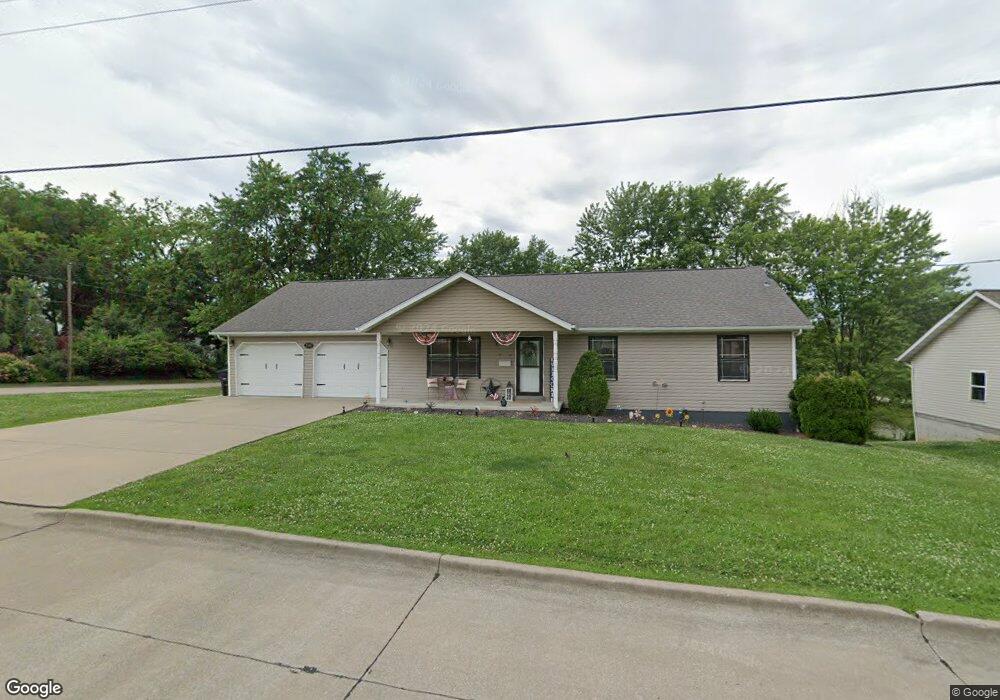
206 Ash St Perryville, MO 63775
Estimated Value: $244,846 - $308,000
3
Beds
2
Baths
1,488
Sq Ft
$181/Sq Ft
Est. Value
About This Home
This home is located at 206 Ash St, Perryville, MO 63775 and is currently estimated at $269,462, approximately $181 per square foot. 206 Ash St is a home located in Perry County with nearby schools including Perryville Elementary School, Perry County Middle School, and Perryville Senior High School.
Ownership History
Date
Name
Owned For
Owner Type
Purchase Details
Closed on
Nov 19, 2021
Sold by
Ebr Properties Inc
Bought by
Cowell Jason W
Current Estimated Value
Home Financials for this Owner
Home Financials are based on the most recent Mortgage that was taken out on this home.
Original Mortgage
$210,900
Outstanding Balance
$192,258
Interest Rate
3.07%
Mortgage Type
Construction
Estimated Equity
$77,204
Purchase Details
Closed on
Aug 4, 2010
Bought by
Ebr Properties Inc
Create a Home Valuation Report for This Property
The Home Valuation Report is an in-depth analysis detailing your home's value as well as a comparison with similar homes in the area
Home Values in the Area
Average Home Value in this Area
Purchase History
| Date | Buyer | Sale Price | Title Company |
|---|---|---|---|
| Cowell Jason W | $263,625 | -- | |
| Ebr Properties Inc | -- | -- |
Source: Public Records
Mortgage History
| Date | Status | Borrower | Loan Amount |
|---|---|---|---|
| Open | Cowell Jason W | $210,900 |
Source: Public Records
Tax History
| Year | Tax Paid | Tax Assessment Tax Assessment Total Assessment is a certain percentage of the fair market value that is determined by local assessors to be the total taxable value of land and additions on the property. | Land | Improvement |
|---|---|---|---|---|
| 2025 | $1,959 | $38,926 | $6,600 | $32,326 |
| 2024 | $1,841 | $35,435 | $5,557 | $29,878 |
| 2023 | $1,836 | $35,435 | $5,557 | $29,878 |
| 2022 | $1,789 | $34,509 | $4,631 | $29,878 |
| 2021 | $1,693 | $32,642 | $4,631 | $28,011 |
| 2020 | $1,587 | $30,347 | $3,997 | $26,350 |
| 2019 | $1,583 | $30,347 | $3,997 | $26,350 |
| 2018 | $1,388 | $29,443 | $3,997 | $25,446 |
| 2017 | $1,388 | $29,443 | $3,997 | $25,446 |
| 2016 | $1,388 | $27,387 | $3,997 | $23,390 |
| 2015 | -- | $27,387 | $3,997 | $23,390 |
| 2014 | -- | $27,032 | $3,841 | $23,191 |
Source: Public Records
Map
Nearby Homes
- 413 E Sainte Marie St
- 122 N Walnut St
- 230 N Walnut St
- 24 S Walnut St
- 23/25/27 W Saint Joseph St
- 221 W Saint Joseph St
- 101 Ganahl St
- 317 S Shelby St
- 522 Edgemont Blvd
- 909 Schindler Rd
- 0 N Highway 51
- Lot 12,13,14 Dorothy Dr
- 1021 Grand Ave
- 110 S Moulton St
- 700 Big Spring Blvd
- 1841 N Main St
- 1512 Old Saint Marys Rd
- 1012 Elliot Ct
- 415 S French Ln
- 1656 Redbud Ct
Your Personal Tour Guide
Ask me questions while you tour the home.