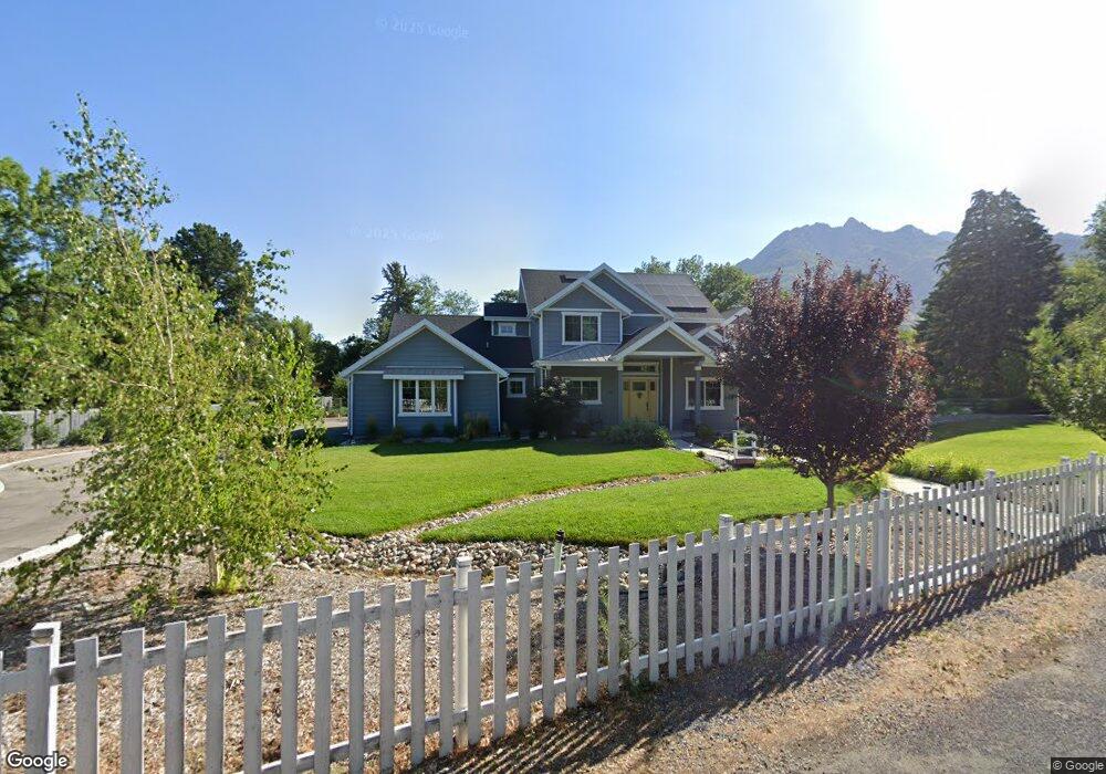
2093 E Pheasant Way Holladay, UT 84121
Estimated Value: $1,966,000 - $2,956,508
3
Beds
3
Baths
4,609
Sq Ft
$564/Sq Ft
Est. Value
About This Home
This home is located at 2093 E Pheasant Way, Holladay, UT 84121 and is currently estimated at $2,597,503, approximately $563 per square foot. 2093 E Pheasant Way is a home with nearby schools including Oakwood Elementary School, Bonneville Junior High School, and Cottonwood High School.
Ownership History
Date
Name
Owned For
Owner Type
Purchase Details
Closed on
Jul 23, 2025
Sold by
Mcclanahan Margaret Jean Hulme and Mcclanahan Craig J
Bought by
Mac Clan Utah Asset Protection Trust and Mcclanahan
Current Estimated Value
Purchase Details
Closed on
Oct 24, 2017
Sold by
The Melvi J And Joy N Hulme 1997 Recable
Bought by
Mcclanahan Margaret Jean Hulme and Mcclanahan Craig James
Purchase Details
Closed on
Oct 27, 1997
Sold by
Hulme Melvin J and Hulme Joy N
Bought by
Hulme Melvin J and Hulme Joy N
Create a Home Valuation Report for This Property
The Home Valuation Report is an in-depth analysis detailing your home's value as well as a comparison with similar homes in the area
Home Values in the Area
Average Home Value in this Area
Purchase History
| Date | Buyer | Sale Price | Title Company |
|---|---|---|---|
| Mac Clan Utah Asset Protection Trust | -- | None Listed On Document | |
| Mcclanahan Margaret Jean Hulme | -- | None Available | |
| Hulme Melvin J | -- | -- |
Source: Public Records
Tax History
| Year | Tax Paid | Tax Assessment Tax Assessment Total Assessment is a certain percentage of the fair market value that is determined by local assessors to be the total taxable value of land and additions on the property. | Land | Improvement |
|---|---|---|---|---|
| 2025 | $11,788 | $2,324,200 | $686,200 | $1,638,000 |
| 2024 | $11,788 | $2,133,700 | $638,400 | $1,495,300 |
| 2023 | $11,799 | $2,080,900 | $608,000 | $1,472,900 |
| 2022 | $11,359 | $2,013,300 | $596,000 | $1,417,300 |
| 2021 | $9,814 | $1,510,900 | $541,800 | $969,100 |
| 2020 | $8,998 | $1,373,400 | $500,500 | $872,900 |
| 2019 | $4,807 | $714,500 | $500,500 | $214,000 |
| 2018 | $6,194 | $489,800 | $489,800 | $0 |
| 2017 | $5,866 | $489,800 | $489,800 | $0 |
| 2016 | $5,666 | $475,700 | $475,700 | $0 |
| 2015 | $5,783 | $452,900 | $452,900 | $0 |
| 2014 | $5,877 | $452,900 | $452,900 | $0 |
Source: Public Records
Map
Nearby Homes
- 2062 E Walker Ln
- 2113 E Fardown Ave
- 5845 S 1900 E
- 5575 S Merlyn Cir
- 1932 E Charleston Ln
- 5946 S Highland Dr
- 2318 E Walker Ln
- 6019 S 2180 E
- 6048 S 2075 E
- 6066 S 2075 E
- 1908 Baywood Dr
- 2323 E Walker Ln
- 5750 Glenbrook Dr
- 6150 Murdoch Woods Place
- 2051 E Normandywoods Ct
- 6176 S Verness Cove
- 1944 Spring Ln
- 5308 S Baywood Cir
- 1801 E Norma Cir
- 5795 S Minden Dr
- 2113 Pheasant Way
- 2073 Pheasant Way
- 2102 E Pheasant Way
- 2102 E Pheasant Way
- 2102 Pheasant Way
- 2084 Pheasant Way
- 2067 Pheasant Cir
- 2131 Pheasant Way
- 2120 Pheasant Way
- 2075 Pheasant Way
- 2075 E Pheasant Way
- 2070 Pheasant Way
- 2071 E Pheasant Way
- 2134 E Pheasant Way
- 5619 S Pheasant Ln
- 5690 Pheasant Ln
- 2134 Pheasant Way
- 2053 Pheasant Cir
- 5650 S Pheasant Ln
- 2076 Pheasant Way
Your Personal Tour Guide
Ask me questions while you tour the home.