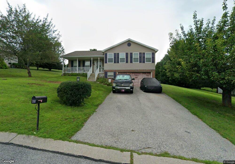
210 Sand Patch Ln Stewartstown, PA 17363
Estimated Value: $309,344 - $376,000
2
Beds
1
Bath
1,232
Sq Ft
$277/Sq Ft
Est. Value
About This Home
This home is located at 210 Sand Patch Ln, Stewartstown, PA 17363 and is currently estimated at $341,086, approximately $276 per square foot. 210 Sand Patch Ln is a home located in York County with nearby schools including South Eastern Intermediate School, South Eastern Middle School, and Kennard-Dale High School.
Ownership History
Date
Name
Owned For
Owner Type
Purchase Details
Closed on
Jul 14, 2000
Sold by
Myers Joseph A
Bought by
Deets Melvin H and Deets Marie E
Current Estimated Value
Home Financials for this Owner
Home Financials are based on the most recent Mortgage that was taken out on this home.
Original Mortgage
$45,450
Outstanding Balance
$16,574
Interest Rate
8.5%
Estimated Equity
$324,512
Create a Home Valuation Report for This Property
The Home Valuation Report is an in-depth analysis detailing your home's value as well as a comparison with similar homes in the area
Home Values in the Area
Average Home Value in this Area
Purchase History
| Date | Buyer | Sale Price | Title Company |
|---|---|---|---|
| Deets Melvin H | $138,987 | -- |
Source: Public Records
Mortgage History
| Date | Status | Borrower | Loan Amount |
|---|---|---|---|
| Open | Deets Melvin H | $45,450 |
Source: Public Records
Tax History
| Year | Tax Paid | Tax Assessment Tax Assessment Total Assessment is a certain percentage of the fair market value that is determined by local assessors to be the total taxable value of land and additions on the property. | Land | Improvement |
|---|---|---|---|---|
| 2025 | $4,875 | $166,050 | $54,210 | $111,840 |
| 2024 | $4,875 | $166,050 | $54,210 | $111,840 |
| 2023 | $4,875 | $166,050 | $54,210 | $111,840 |
| 2022 | $4,875 | $166,050 | $54,210 | $111,840 |
| 2021 | $4,709 | $166,050 | $54,210 | $111,840 |
| 2020 | $4,709 | $166,050 | $54,210 | $111,840 |
| 2019 | $4,693 | $166,050 | $54,210 | $111,840 |
| 2018 | $4,693 | $166,050 | $54,210 | $111,840 |
| 2017 | $4,693 | $166,050 | $54,210 | $111,840 |
| 2016 | $0 | $166,050 | $54,210 | $111,840 |
| 2015 | -- | $166,050 | $54,210 | $111,840 |
| 2014 | -- | $166,050 | $54,210 | $111,840 |
Source: Public Records
Map
Nearby Homes
- 17995 Dave Anne Cir
- 17 Charles Ave
- 18016 Dave Anne Cir
- 480 Hollow Rd
- 70 Piston Ct
- 55 Brakeman Dr
- 29 High St
- 254 Hollow Rd
- 9 W Pennsylvania Ave
- 0 Mill St Unit 64
- 304 N Marshview Rd Unit 304
- 18183 Piedmont Rd
- 12 Locust St
- 3870 Autumn Ln
- 19367 Barrens Rd S
- 15138 Little Rd
- 5086 Lakewood Ln
- 0 Five Forks Rd Unit PAYK2095070
- 0 Five Forks Rd Unit PAYK2095050
- 15898 McDowell Farm Ln
- 219 E Scarborough Fare
- 214 Sand Patch Ln
- 205 Runningboard Rd
- 223 E Scarborough Fare
- 211 Sand Patch Ln
- 220 Sand Patch Ln
- 209 Runningboard Rd
- 205 Sand Patch Ln
- 215 Sand Patch Ln
- 215 Runningboard Rd
- 219 Sand Patch Ln
- 211 E Scarborough Fare
- 226 Sand Patch Ln
- 218 E Scarborough Fare
- 222 E Scarborough Fare
- 214 E Scarborough Fare
- 206 Runningboard Rd
- 229 E Scarborough Fare
- 226 E Scarborough Fare
- 223 Sand Patch Ln
Your Personal Tour Guide
Ask me questions while you tour the home.