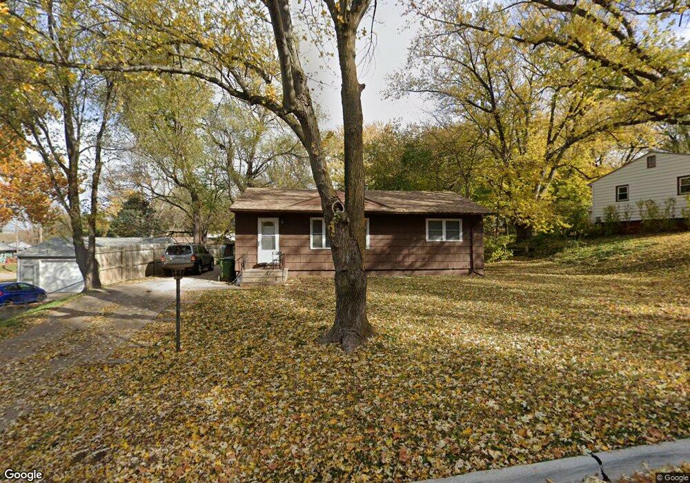
2110 Power Dr Bellevue, NE 68005
Estimated Value: $216,000 - $244,000
About This Home
This home is located at 2110 Power Dr, Bellevue, NE 68005 and is currently estimated at $225,510, approximately $131 per square foot. 2110 Power Dr is a home located in Sarpy County with nearby schools including Avery Elementary School, Logan Fontenelle Middle School, and Bellevue East High School.
Ownership History
We collect this data history from publicly available records. To have your information removed, we recommend requesting removal directly through your county’s website.
Purchase Details
Home Financials for this Owner
Home Financials are based on the most recent Mortgage that was taken out on this home.Purchase Details
Home Values in the Area
Average Home Value in this Area
Purchase History
We collect this data history from publicly available records. To have your information removed, we recommend requesting removal directly through your county’s website.
| Date | Buyer | Sale Price | Title Company |
|---|---|---|---|
| $90,000 | -- | ||
| $65,000 | Tower Title & Escrow Co |
Mortgage History
We collect this data history from publicly available records. To have your information removed, we recommend requesting removal directly through your county’s website.
| Date | Status | Borrower | Loan Amount |
|---|---|---|---|
| Open | $89,200 |
Tax History
We collect this data history from publicly available records. To have your information removed, we recommend requesting removal directly through your county’s website.
| Year | Tax Paid | Tax Assessment Tax Assessment Total Assessment is a certain percentage of the fair market value that is determined by local assessors to be the total taxable value of land and additions on the property. | Land | Improvement |
|---|---|---|---|---|
| 2025 | $3,141 | $193,783 | $31,000 | $162,783 |
| 2024 | $3,515 | $180,193 | $27,000 | $153,193 |
| 2023 | $3,515 | $166,459 | $26,000 | $140,459 |
| 2022 | $3,402 | $158,068 | $26,000 | $132,068 |
| 2021 | $3,021 | $138,883 | $26,000 | $112,883 |
| 2020 | $2,810 | $128,770 | $17,000 | $111,770 |
| 2019 | $2,597 | $119,775 | $17,000 | $102,775 |
| 2018 | $2,419 | $114,571 | $17,000 | $97,571 |
| 2017 | $2,290 | $107,712 | $17,000 | $90,712 |
| 2016 | $2,227 | $107,053 | $17,000 | $90,053 |
| 2015 | $2,211 | $106,891 | $17,000 | $89,891 |
| 2014 | $2,188 | $105,122 | $17,000 | $88,122 |
| 2012 | -- | $94,704 | $17,000 | $77,704 |
Map
- 1908 Gregg Rd
- 1901 Winnie Dr Unit 3
- 102 Hillcrest Ave
- 103 Hillcrest Ave
- 9904 S 9th Cir
- 2102 Avery Rd E
- 2006 Fairview St
- 305 Kohl Rd
- 204 Sandi Ct
- 1207 Kasper St
- 105 Martin Dr
- 1206 Skyview Dr
- 1011 Bea Cir
- LOT 11A1B Tbd
- 707 Bellevue Blvd N
- 1910 Lindyview Ln
- 1411 Sunbury Dr
- 1304 Englewood Dr
- 1418 Fairfax Rd
- 206 Bellevue Blvd S
Ask me questions while you tour the home.