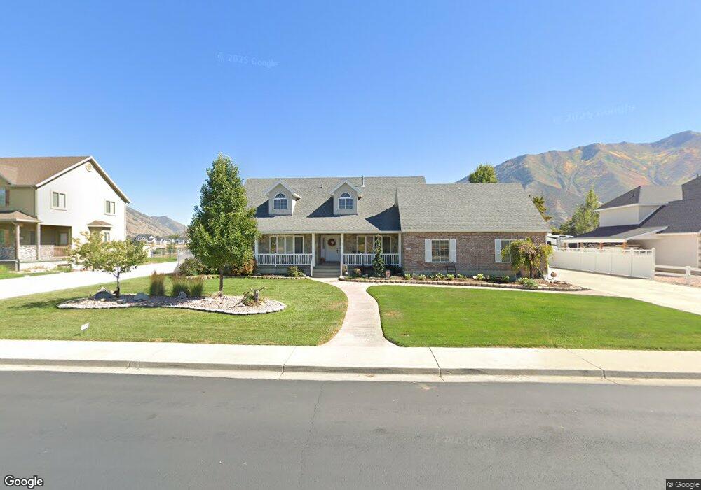
212 N 1100 W Mapleton, UT 84664
Estimated Value: $726,000 - $879,000
2
Beds
3
Baths
1,819
Sq Ft
$446/Sq Ft
Est. Value
About This Home
This home is located at 212 N 1100 W, Mapleton, UT 84664 and is currently estimated at $811,025, approximately $445 per square foot. 212 N 1100 W is a home located in Utah County with nearby schools including Mapleton School, Mapleton Junior High School, and Maple Mountain High School.
Ownership History
Date
Name
Owned For
Owner Type
Purchase Details
Closed on
Dec 6, 2024
Sold by
Errol Boyd Whitlock Trust and Carol Lillian Whitlock Trust
Bought by
Errol Whitlock And Carol Whitlock Family Trus and Whitlock
Current Estimated Value
Purchase Details
Closed on
Sep 20, 2024
Sold by
Whitlock Errol B and Whitlock Carol C
Bought by
Errol Boyd Whitlock Trust and Carol Lillian Whitlock Trust
Create a Home Valuation Report for This Property
The Home Valuation Report is an in-depth analysis detailing your home's value as well as a comparison with similar homes in the area
Home Values in the Area
Average Home Value in this Area
Purchase History
| Date | Buyer | Sale Price | Title Company |
|---|---|---|---|
| Errol Whitlock And Carol Whitlock Family Trus | -- | None Listed On Document | |
| Errol Boyd Whitlock Trust | -- | None Listed On Document |
Source: Public Records
Tax History
| Year | Tax Paid | Tax Assessment Tax Assessment Total Assessment is a certain percentage of the fair market value that is determined by local assessors to be the total taxable value of land and additions on the property. | Land | Improvement |
|---|---|---|---|---|
| 2025 | $4,237 | $428,010 | -- | -- |
| 2024 | $4,237 | $415,085 | $0 | $0 |
| 2023 | $4,459 | $439,560 | $0 | $0 |
| 2022 | $5,183 | $505,230 | $0 | $0 |
| 2021 | $4,373 | $654,400 | $271,200 | $383,200 |
| 2020 | $4,204 | $608,500 | $240,000 | $368,500 |
| 2019 | $3,793 | $560,400 | $240,000 | $320,400 |
| 2018 | $3,735 | $525,400 | $205,000 | $320,400 |
| 2017 | $3,453 | $257,730 | $0 | $0 |
| 2016 | $3,288 | $243,980 | $0 | $0 |
| 2015 | $3,159 | $232,980 | $0 | $0 |
| 2014 | $2,865 | $207,515 | $0 | $0 |
Source: Public Records
Map
Nearby Homes
- 1142 W 220 N
- 1222 W 190 N
- 1272 W 220 N
- 126 N 800 W
- 754 W 400 N Unit 29
- 648 W 400 N
- 4664 S 680 W Unit S204
- 4664 S 680 W Unit S203
- 4664 S 680 W Unit S302
- 4664 S 680 W Unit S303
- 4664 S 680 W Unit S201
- 4664 S 680 W Unit S202
- 4664 S 680 W Unit S304
- 4664 S 680 W Unit S301
- 4664 S 680 W Unit S102
- 4664 S 680 W Unit S101
- 1446 W 600 N Unit 5
- 572 W 500 N
- 1512 W 600 N Unit 4
- 415 S 1200 W
- 186 N 1100 W
- 234 N 1100 W
- 178 N 1100 W
- 152 N 1100 W
- 272 N 1100 W
- 272 N 1100 W Unit 1
- 188 N 1140 W Unit 6
- 188 N 1140 W
- 1143 N 1100 W
- 152 N 1140 W Unit 7
- 152 N 1140 W
- 118 N 1100 W
- 128 N 1140 W Unit 8
- 128 N 1140 W
- 189 N 1140 W
- 189 N 1140 W Unit 16
- 322 N 1100 W
- 1152 W 120 N Unit 15
- 1152 W 120 N
- 120 N 1140 W Unit 9
Your Personal Tour Guide
Ask me questions while you tour the home.