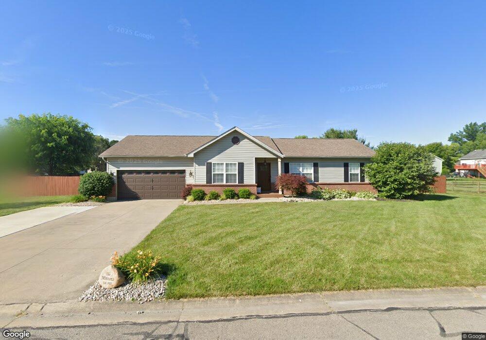
212 Robin Ave Mount Orab, OH 45154
Mount Orab AreaEstimated Value: $275,000 - $290,000
About This Home
This home is located at 212 Robin Ave, Mount Orab, OH 45154 and is currently estimated at $280,841, approximately $185 per square foot. 212 Robin Ave is a home located in Brown County with nearby schools including Western Brown High School.
Ownership History
We collect this data history from publicly available records. To have your information removed, we recommend requesting removal directly through your county’s website.
Purchase Details
Home Financials for this Owner
Home Financials are based on the most recent Mortgage that was taken out on this home.Purchase Details
Home Financials for this Owner
Home Financials are based on the most recent Mortgage that was taken out on this home.Purchase Details
Purchase Details
Home Values in the Area
Average Home Value in this Area
Purchase History
We collect this data history from publicly available records. To have your information removed, we recommend requesting removal directly through your county’s website.
| Date | Buyer | Sale Price | Title Company |
|---|---|---|---|
| $258,000 | None Listed On Document | ||
| $125,333 | Homestead Title Agency Ltd | ||
| $112,900 | -- | ||
| $13,000 | -- |
Mortgage History
We collect this data history from publicly available records. To have your information removed, we recommend requesting removal directly through your county’s website.
| Date | Status | Borrower | Loan Amount |
|---|---|---|---|
| Open | $260,606 | ||
| Previous Owner | $126,000 | ||
| Previous Owner | $111,000 | ||
| Previous Owner | $112,500 | ||
| Previous Owner | $123,830 |
Tax History
We collect this data history from publicly available records. To have your information removed, we recommend requesting removal directly through your county’s website.
| Year | Tax Paid | Tax Assessment Tax Assessment Total Assessment is a certain percentage of the fair market value that is determined by local assessors to be the total taxable value of land and additions on the property. | Land | Improvement |
|---|---|---|---|---|
| 2025 | $2,438 | $76,600 | $9,100 | $67,500 |
| 2024 | $2,438 | $76,600 | $9,100 | $67,500 |
| 2023 | $2,438 | $47,970 | $8,320 | $39,650 |
| 2022 | $1,612 | $47,970 | $8,320 | $39,650 |
| 2021 | $1,547 | $47,970 | $8,320 | $39,650 |
| 2020 | $1,359 | $39,970 | $6,930 | $33,040 |
| 2019 | $1,448 | $39,970 | $6,930 | $33,040 |
| 2018 | $1,431 | $39,970 | $6,930 | $33,040 |
| 2017 | $1,243 | $33,860 | $6,930 | $26,930 |
| 2016 | $1,244 | $33,860 | $6,930 | $26,930 |
| 2015 | $1,187 | $33,860 | $6,930 | $26,930 |
| 2014 | $1,191 | $33,230 | $6,300 | $26,930 |
| 2013 | $1,188 | $33,230 | $6,300 | $26,930 |
Map
- 433 Liming Farm Rd
- 104 N High St
- 0 State Route 32 Unit 1795308
- 333 E Main St
- 108 Keethler St
- 506 E Main St
- 506 E Main St
- 203 Bingaman Ln
- 206 Bingaman Ln
- 321 Pleasant St
- 3517 Bardwell Buford Rd
- 327 Glover Meadows Way
- 126 Lonny St
- 320 Glover Meadows Way
- 322 Glover Meadows Way
- 324 Glover Meadows Way
- 224 Gregory St
- 326 Glover Meadows Way
- 328 Glover Meadows Way
- 4464 Tri County Hwy
Ask me questions while you tour the home.