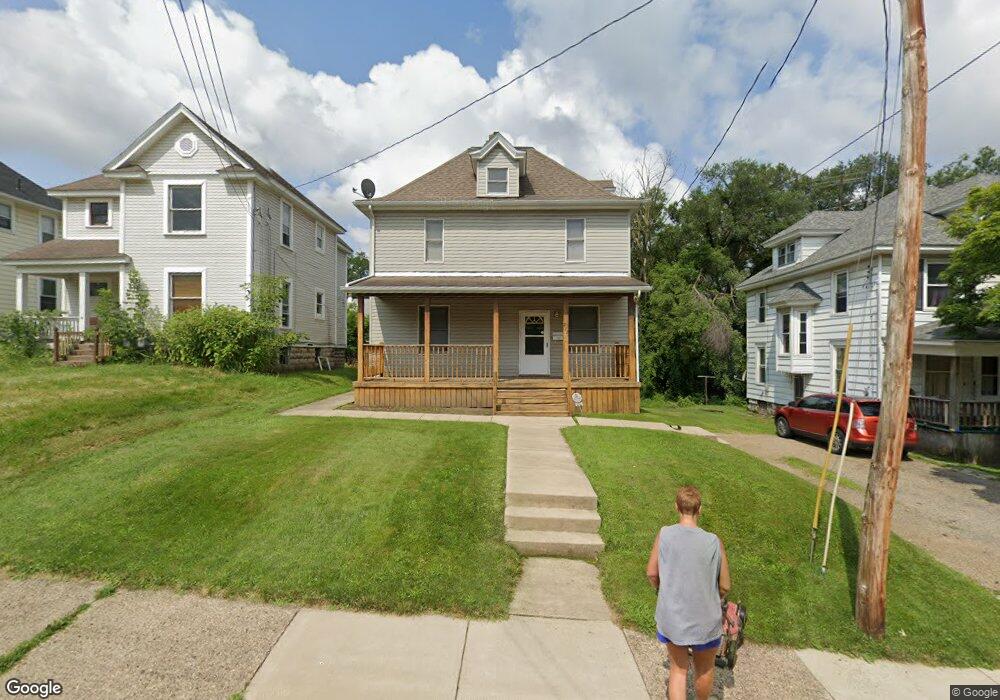
212 S Mulberry St Mansfield, OH 44903
Estimated Value: $100,000 - $180,000
4
Beds
2
Baths
1,836
Sq Ft
$66/Sq Ft
Est. Value
About This Home
This home is located at 212 S Mulberry St, Mansfield, OH 44903 and is currently estimated at $122,044, approximately $66 per square foot. 212 S Mulberry St is a home located in Richland County with nearby schools including St. Peter's Elementary/Montessori School, Discovery School, and St. Peter's Junior High / High School.
Ownership History
Date
Name
Owned For
Owner Type
Purchase Details
Closed on
Apr 5, 2019
Sold by
Gilbert Michelle D
Bought by
Gilbert Michelle D and Michelle D Gilbert Trust
Current Estimated Value
Purchase Details
Closed on
Oct 16, 2015
Sold by
Gilbert Stan L and Gilbert Michelle D
Bought by
Gilbert Michelle D
Purchase Details
Closed on
Apr 15, 2003
Sold by
Gilbert Stan L and Gilbert Michelle D
Bought by
Gilbert Stan L and Gilbert Michelle D
Purchase Details
Closed on
May 27, 1994
Sold by
Johnson Garland R
Bought by
Gilbert Stan L
Create a Home Valuation Report for This Property
The Home Valuation Report is an in-depth analysis detailing your home's value as well as a comparison with similar homes in the area
Home Values in the Area
Average Home Value in this Area
Purchase History
| Date | Buyer | Sale Price | Title Company |
|---|---|---|---|
| Gilbert Michelle D | -- | None Available | |
| Gilbert Michelle D | -- | Attorney | |
| Gilbert Stan L | -- | American Mid Ohio Title Agen | |
| Gilbert Stan L | $10,300 | -- |
Source: Public Records
Tax History
| Year | Tax Paid | Tax Assessment Tax Assessment Total Assessment is a certain percentage of the fair market value that is determined by local assessors to be the total taxable value of land and additions on the property. | Land | Improvement |
|---|---|---|---|---|
| 2025 | $1,096 | $22,890 | $2,710 | $20,180 |
| 2024 | $1,096 | $22,890 | $2,710 | $20,180 |
| 2023 | $1,096 | $22,890 | $2,710 | $20,180 |
| 2022 | $892 | $15,620 | $2,220 | $13,400 |
| 2021 | $899 | $15,620 | $2,220 | $13,400 |
| 2020 | $919 | $15,620 | $2,220 | $13,400 |
| 2019 | $1,019 | $15,620 | $2,220 | $13,400 |
| 2018 | $1,005 | $15,620 | $2,220 | $13,400 |
| 2017 | $1,144 | $15,620 | $2,220 | $13,400 |
| 2016 | $1,309 | $20,270 | $2,560 | $17,710 |
| 2015 | $1,309 | $20,270 | $2,560 | $17,710 |
| 2014 | $1,234 | $20,270 | $2,560 | $17,710 |
| 2012 | $473 | $20,270 | $2,690 | $17,580 |
Source: Public Records
Map
Nearby Homes
- 212 S Main St
- 74 & 78 Lexington Ave
- 286 S Main St
- 120 Distl Ave
- 273 Hammond Ave
- 219 Lexington Ave
- 167 S Adams St
- 394 S Main St
- 27 Dunbilt Ct
- 135 Wood St
- 0 Cline Ave Hedeen Abbeyfeale Unit 9066362
- 183 Carpenter Rd
- 146 E 1st St
- 223 Hedges St
- 195 Hedges St
- 157 Marion Ave
- 51 Lind Ave
- 245 W 4th St
- 507 Townview Cir E
- 30 Douglas Ave
- 216 S Mulberry St
- 206 S Mulberry St
- 220 S Mulberry St
- 202 S Mulberry St
- 88 Glenwood Heights
- 224 S Mulberry St
- 73 Ohio St
- 198 S Mulberry St
- 228 S Mulberry St
- 83 Ohio St
- 211 S Mulberry St
- 196 S Mulberry St
- 92 Glenwood Heights
- 97 Glenwood Heights
- 79 Glessner Ave
- 232 S Mulberry St
- 81 Ohio St
- 215 S Mulberry St
- 207 S Mulberry St
- 103 Glenwood Heights
Your Personal Tour Guide
Ask me questions while you tour the home.