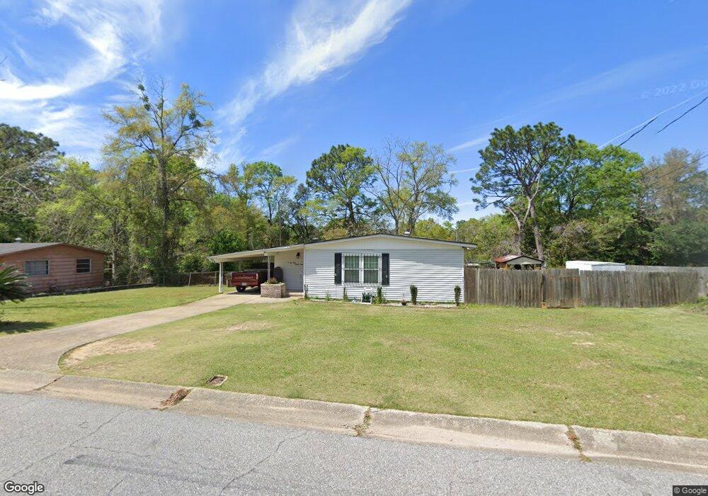
2121 Cornell Dr Mobile, AL 36618
Estimated Value: $63,000 - $153,000
3
Beds
2
Baths
1,696
Sq Ft
$71/Sq Ft
Est. Value
About This Home
This home is located at 2121 Cornell Dr, Mobile, AL 36618 and is currently estimated at $120,577, approximately $71 per square foot. 2121 Cornell Dr is a home located in Mobile County with nearby schools including Forest Hill Elementary School, CL Scarborough Middle School, and Mattie T Blount High School.
Ownership History
Date
Name
Owned For
Owner Type
Purchase Details
Closed on
Aug 12, 2011
Sold by
Secretary Of Housing & Urban Development
Bought by
Rankin Robert J
Current Estimated Value
Home Financials for this Owner
Home Financials are based on the most recent Mortgage that was taken out on this home.
Original Mortgage
$46,293
Outstanding Balance
$31,783
Interest Rate
4.62%
Mortgage Type
FHA
Estimated Equity
$88,794
Purchase Details
Closed on
Jun 11, 2010
Sold by
Cooper Ted W and Cooper Kimberly Y
Bought by
Midfirst Bank
Purchase Details
Closed on
May 11, 2010
Sold by
Midfirst Bank
Bought by
The Secretary Of Housing & Urban Develop
Purchase Details
Closed on
May 30, 2007
Sold by
Cooper Ted W
Bought by
Cooper Kimberly Y
Purchase Details
Closed on
Jun 29, 1999
Sold by
Davis Jackie R and Davis Lois M
Bought by
Cooper Ted W and Cooper Kimberly Y
Home Financials for this Owner
Home Financials are based on the most recent Mortgage that was taken out on this home.
Original Mortgage
$60,818
Interest Rate
7.27%
Mortgage Type
FHA
Create a Home Valuation Report for This Property
The Home Valuation Report is an in-depth analysis detailing your home's value as well as a comparison with similar homes in the area
Purchase History
We collect this data history from publicly available records. To have your information removed, we recommend requesting removal directly through your county’s website.
| Date | Buyer | Sale Price | Title Company |
|---|---|---|---|
| Rankin Robert J | -- | None Available | |
| Midfirst Bank | $89,883 | None Available | |
| The Secretary Of Housing & Urban Develop | -- | None Available | |
| Cooper Kimberly Y | -- | None Available | |
| Cooper Ted W | -- | -- |
Source: Public Records
Mortgage History
We collect this data history from publicly available records. To have your information removed, we recommend requesting removal directly through your county’s website.
| Date | Status | Borrower | Loan Amount |
|---|---|---|---|
| Open | Rankin Robert J | $46,293 | |
| Previous Owner | Cooper Ted W | $60,818 |
Source: Public Records
Tax History
| Year | Tax Paid | Tax Assessment Tax Assessment Total Assessment is a certain percentage of the fair market value that is determined by local assessors to be the total taxable value of land and additions on the property. | Land | Improvement |
|---|---|---|---|---|
| 2025 | -- | $7,210 | $1,000 | $6,210 |
| 2024 | -- | $6,560 | $1,000 | $5,560 |
| 2023 | $0 | $6,400 | $1,000 | $5,400 |
| 2022 | $0 | $6,110 | $1,000 | $5,110 |
| 2021 | $0 | $5,710 | $800 | $4,910 |
| 2020 | $384 | $5,530 | $600 | $4,930 |
| 2019 | $384 | $5,340 | $600 | $4,740 |
| 2018 | $0 | $5,360 | $0 | $0 |
| 2017 | $0 | $5,080 | $0 | $0 |
| 2016 | $384 | $7,100 | $0 | $0 |
| 2013 | $404 | $6,960 | $0 | $0 |
Source: Public Records
Map
Nearby Homes
- 2113 Cornell Dr
- 2205 Beau Terra Dr W
- 2004 Beau Terra Dr W
- 4060 Dickson Ln
- 1758 La Pine Dr
- 0 Wolfridge Rd
- 2210 Wolf Ridge Rd
- 0 Junius Ln
- 1510 Northview Dr
- 4148 Siesta Dr
- 6632 Monarch Cir
- 1716 Woodley Rd
- 4453 Myers Rd
- 3531 Anton St
- 3514 Anton St
- 3751 Superior Dr
- 1124 Forest Glen Dr N
- 3927 Moffett Rd
- 4708 Belle Wood Dr S
- 3728 Vinewood Dr
- 2117 Cornell Dr
- 2125 Cornell Dr
- 2150 Beau Terra Dr W
- 2124 Beau Terra Dr W
- 2118 Cornell Dr
- 4157 Stanford Dr
- 2122 Cornell Dr
- 2114 Cornell Dr
- 2129 Cornell Dr
- 2120 Beau Terra Dr W
- 2110 Cornell Dr
- 2126 Cornell Dr
- 0 Stanford Rd
- 2116 Beau Terra Dr W
- 2109 Cornell Dr
- 2151 Beau Terra Dr W
- 2121 Beau Terra Dr W
- 2130 Cornell Dr
- 2155 Beau Terra Dr W
- 4158 Stanford Dr
Your Personal Tour Guide
Ask me questions while you tour the home.